

The Sentinels are a fleet of European Space Agency (ESA) satellites designed to acquire measurements from multiple sensor types that will provide information necessary to meet Europe’s Copernicus program objectives.
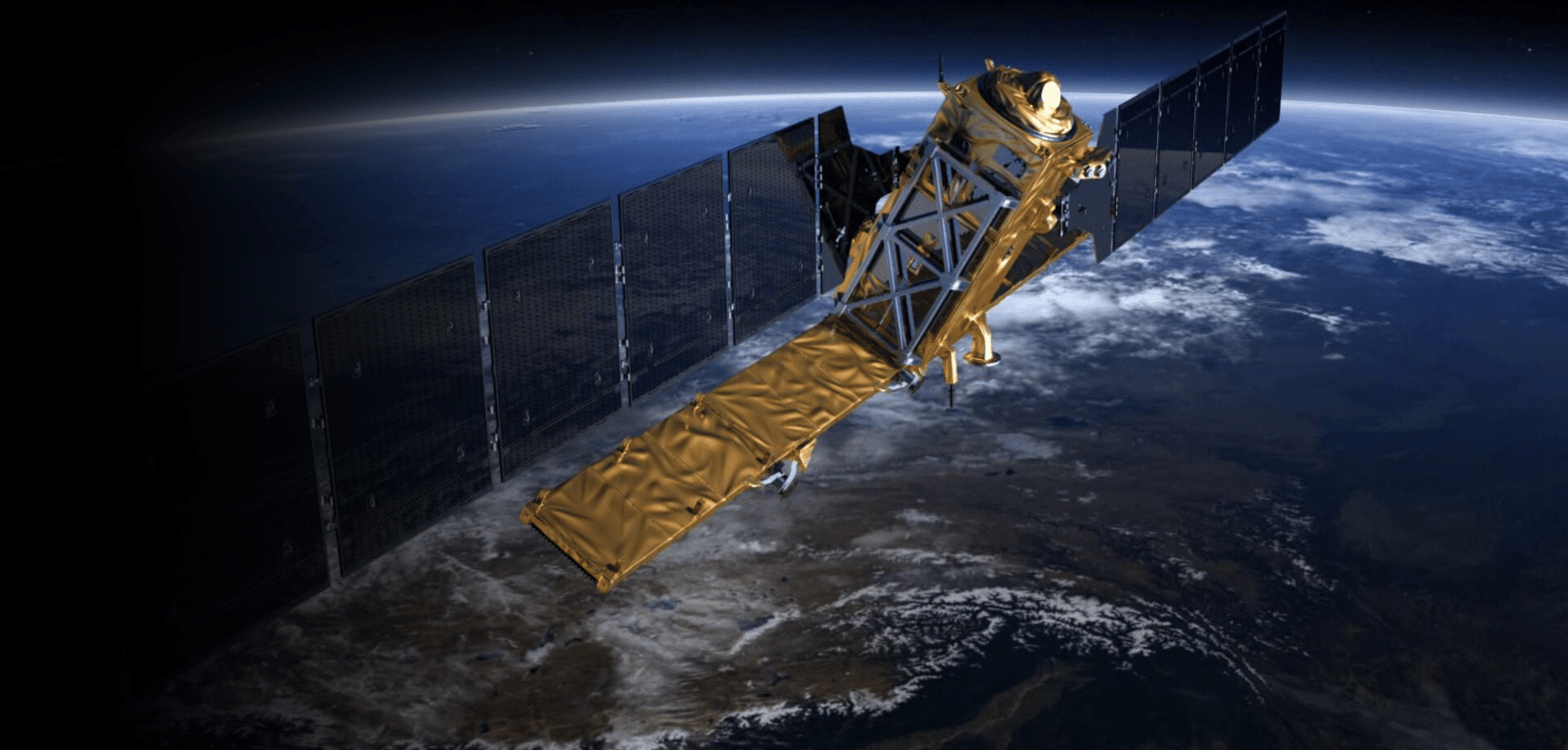
The first mission in the series, the Sentinel-1 constellation, includes twin satellites that each carry C-band synthetic aperture radar (SAR) and together provide all-weather, day-and-night imagery of Earth’s surface.
Sentinel-1A was launched on 3 April 2014, and Sentinel-1B on 25 April 2016. They orbit 180° apart, together imaging the Earth every six days.
- In December 2021, an anomaly in the power supply of Sentinel-1B caused the SAR sensor to stop working. Attempts to restore power to the sensor failed, and the mission officially ended on August 3, 2022.
| Dataset Property | Strip Map (SM) mode | Interferometric Wide (IW) mode | Extra Wide (EW) mode | Wave (WV) mode |
|---|---|---|---|---|
| Temporal Coverage | 12 Days | 12 Days | 12 Days | 12 Days |
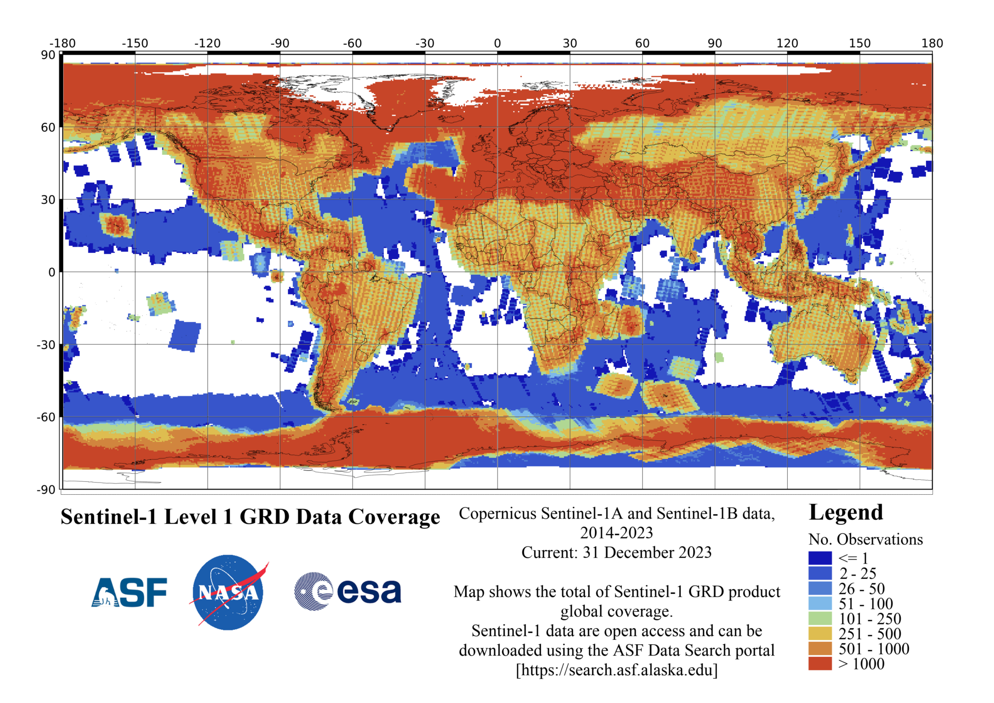
| Spatial Coverage | Global | Global | Global | Global |
| Center Frequency | C-band at 5.405 GHz | C-band at 5.405 GHz | C-band at 5.405 GHz | C-band at 5.405 GHz |
| Polarization | Single Polarization (HH or VV) Dual Polarization (HH+HV or VV+VH) | Single Polarization (HH or VV) Dual Polarization (HH+HV or VV+VH) | Single Polarization (HH or VV) Dual Polarization (HH+HV or VV+VH) | Single Polarization (HH or VV) Dual Polarization (HH+HV or VV+VH) |
| Spatial Resolution | 5 x 5 m | 5 x 20 m | 20 x 40 m | 5 x 5 m |
| Swath Width | 80 km | 250 km | 410 km | 100 km |
| Off-Nadir Angle | 18.3° to 46.8° | 29.1° to 46.0° | 18.9° to 47.0° | 21.6° to 45.1° and 34.8° to 38.0° |
| Download info | Data Discovery | Data Discovery | Data Discovery | Data Discovery |
| File format | SAFE | SAFE | SAFE | SAFE |
| Provider | European Space Agency | European Space Agency | European Space Agency | European Space Agency |
| Date published: | 2014 | 2014 | 2014 | 2014 |
The loss of one of the Sentinel-1 satellites means that the frequency of observations and global coverage will be significantly reduced until the launch and commissioning of Sentinel-1C. This is predicted to be completed in the third quarter of 2023. Sentinel-1B will be deorbited at this time.
The Sentinel-1 constellation benefits numerous services, such as monitoring of Arctic sea-ice extent, routine sea-ice mapping, and surveillance of the marine environment. Applications include oil-spill monitoring and ship detection for maritime security; monitoring land-surface for motion risks; mapping for forest, water, and soil management; and mapping to support humanitarian aid and crisis situations.
Updated August 22, 2022
International Collaboration
Sentinel-1 is the result of close collaboration among ESA, the European Commission, industry, service providers, and data users.
NASA’s provision of the complete ESA Sentinel-1 SAR data archive through the ASF DAAC is by agreement between the U.S. State Department and the European Commission (EC). As part of the Earth-observation Copernicus program, the Sentinel mission will provide scientists with accurate, timely, and easily accessible information to help shape the future of our planet.
Content on ASF’s Sentinel web pages is adapted from ESA’s Sentinel website.
FAQ
| Question | Answer |
|---|---|
| What are the Sentinel-1 product types, and how are the data processed? | Sentinel-1 data products acquired in Stripmap, Interferometric Wide Swath, and Extra Wide Swath modes, generated by the Payload Data Ground Station, are distributed at three levels of processing: Level-0 (called RAW) , Level-1, and Level-2 Level-1 products can be one of two product types — either Single Look Complex (SLC) or Ground Range Detected (GRD). Level-2 Ocean (OCN) products can have different components available depending on the acquisition mode. Products are designated based on their acquisition mode, product type and, in the case of Level-1 GRD, resolution. All products are processed directly from the Level-0 product. Each mode can potentially generate Level-1 SLC, Level-1 GRD and Level-2 Ocean products. For Wave (WV) mode, the Level-0 and Level-1 products are not distributed. Level-2 Ocean Swell Spectra (OSW) component is not available from the TOPSAR modes. Learn about TOPSAR in the “Instrument” section under the “User Guide/Technical Information” tab. |
| What are the different Sentinel-1 beam modes? | Sentinel-1 satellites carry a C-band SAR instrument to provide a combined all-weather, day-and-night supply of imagery of Earth’s surface every six days. The four SAR modes — described in more detail in the “Image Quality” section under the “User Guide Technical Information” tab — are Extra Wide Swath, Interferometric Wide Swath, Stripmap, and Wave. |
| What is the naming convention for Sentinel-1 data? | The naming convention is explained in the graphic below.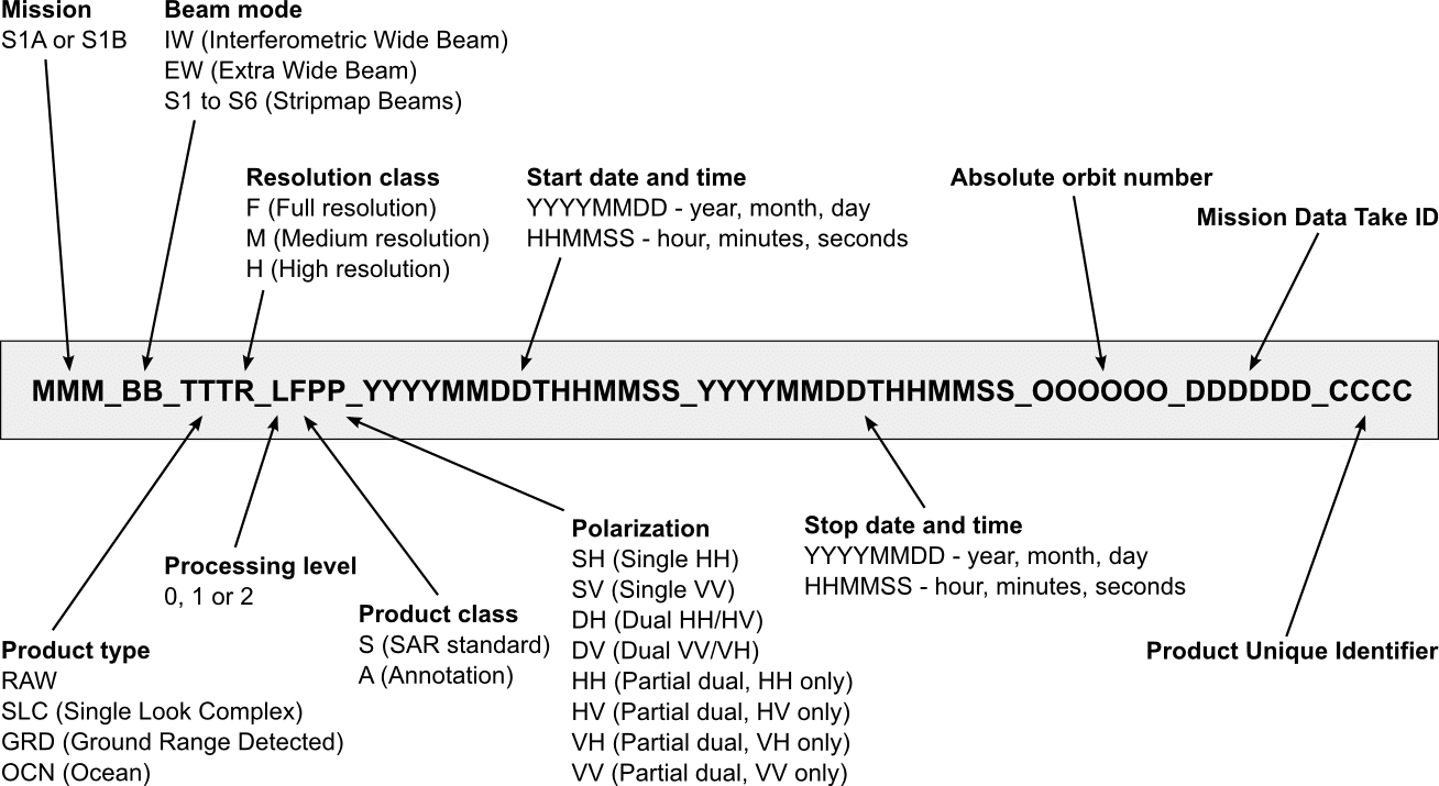 |
| I managed to get some Sentinel-1 files in the download queue, and I downloaded the .metalink, but I wasn’t able to download anything after opening the free download manager. Please advise. | You must be logged in to Vertex in order to download Sentinel-1 data from ASF. If you don’t already have a user account at ASF, please create one on Earthdata. |
| Is there a way to sort Sentinel-1 data in Vertex based on polarization, data type, etc.? | To filter by data product, use the drop-down menu titled at the bottom of the results column. Use the menu to select only those products you want added to your download queue. The bar, at the top of the results column, lets you filter your results by typing in keywords displayed in the granule description, such as path or flight direction. For more detailed sorting, use the and features, and add the results to your download queue. Click the button, and import the resulting file into a spreadsheet. Use the tools in your spreadsheet to sort the metadata — for example, by polarization. Copy and paste the resulting granule names into the window to the left of the map and click. Find additional Vertex help through the tab at the top left of the page. |
| Can I search for Sentinel-1 data over specific areas? | Use the geographic search option in the Vertex Data Portal to identify your area of interest and download Sentinel-1 products available from ASF DAAC. |
| How are Sentinel-1 data formatted? | Sentinel-1 data products are distributed using a Sentinel-specific variation of the Standard Archive Format for Europe (SAFE) format specification. The SAFE format has been designed to act as a common format for archiving and conveying data within ESA Earth Observation archiving facilities. The format wraps a folder containing image data in a binary data format and product metadata in XML. This flexibility allows the format to be scalable enough to represent all levels of Sentinel-1 products. A Sentinel-1 product refers to a directory folder that contains a collection of information. It includes:
|
| Why is the Sentinel-1 file I downloaded failing with a “path too long” error? | The default Windows file extraction utility will often fail because of long Sentinel-1 filenames. The open-source utility 7-Zip can be used to extract the .zip files downloaded from ASF and ESA. |
| Why are there stripes running across my Sentinel-1 EW and IW images? | These beam modes incorporate an acquisition technique (TOPSAR) that produces wide swaths from multiple sub-swaths, or bands, acquired in the direction the satellite is moving. This can create “seams” that are more noticeable in cross-polarized images (HV and VH). IW is acquired using three sub-swaths and EW five sub-swaths. Find more information in the “Instrument” and “Image Quality” sections under the “User Guide/Technical Information” tab. |
| Why do some Sentinel-1 images have stepped ends? | 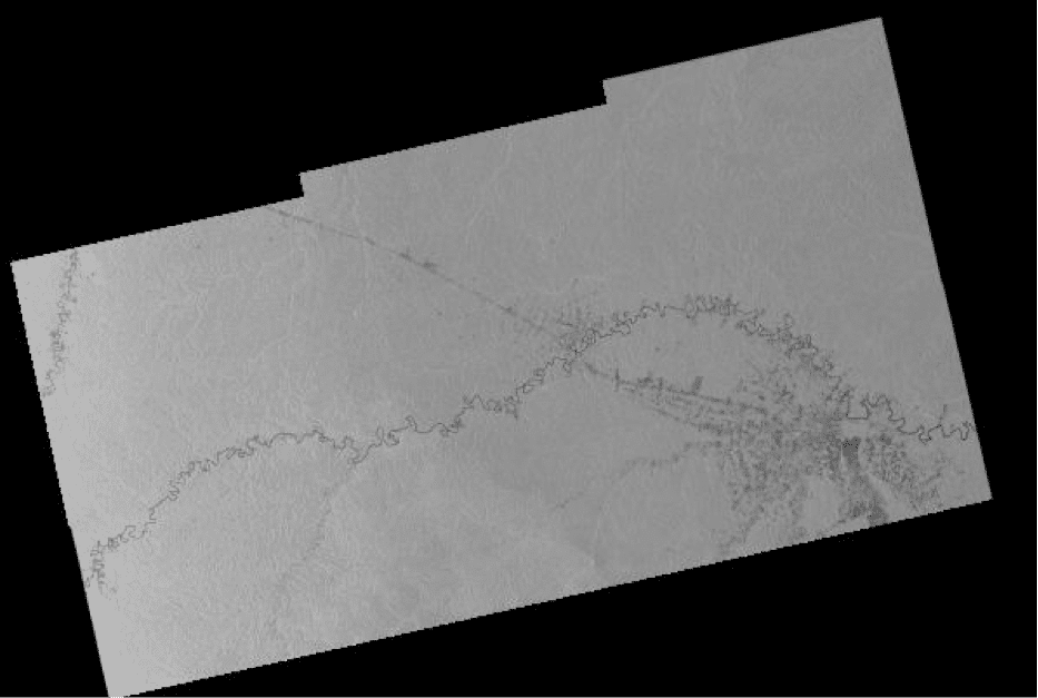 Stepped ends, as in the image to the right, are an artifact of the multi-beam scanning technology of TOPSAR and the way that ESA “slices” a data take into discrete, manageable units. See the “Image Quality” section under the “User Guide Technical Information” tab. |
| Why are some thumbnails and browse images in color and some in grayscale? | Single polarization (HH, VV) images are in grayscale, while dual polarization (HH/HV, VV/VH) images have had color assigned to each polarization channel. |
| Why doesn’t the Sentinel-1 browse image always orient the same direction as the granule outline rendered on the Vertex map? | The Sentinel-1A browse is a geocoded jpeg image displayed in a polar stereo map projection at latitudes above 65° north and south. The Vertex map always displays a granule in a Mercator projection. The browse image below is also an example of stepping (question #10). For more information on image artifacts and anomalies see the “Image Quality” section under the “User Guide/Technical Information” tab.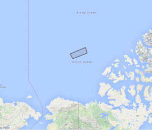 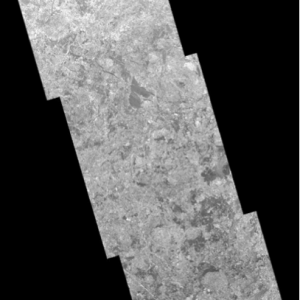 |
| Why are there differences in Sentinel-1 image size between granules in the same beam mode, same swath? | The European Space Agency (ESA) uses slices instead of frames to divide a Sentinel-1 datatake into more manageable units, without any overlap or duplicated lines between slices. Stripmap and Interferometric Wide Swath slices consist of approximately 25 seconds of acquisition, and Extra Wide Swath slices consist of approximately 60 seconds. Each band within a product slice is kept to under 2 GB in size. Depending on the terrain being imaged, slices in the same datatake can have different dimensions in the azimuth direction. Find more information in the “Image Quality” section under the “User Guide/Technical Information” tab. |
| Why does the Alaska Satellite Facility (ASF) use frames for Sentinel-1 data when the European Space Agency (ESA) does not? | ASF DAAC assigns frames to Sentinel-1 product slices that refer to the same point temporally and geographically. In Vertex, search results then display all the products available over a point and time instead of listing the products for the same point individually. For example, a single Sentinel-1 slice can produce RAW, SLC, GRD and OCN products. ASF DAAC uses the internally generated frame number to group these products into a single Vertex search result and to create InSAR stacks or stacks used to color code Vertex results on the map to indicate approximate quantity of repeating observations with the same relative orbit and frame number. |
| Why does ESA have some Sentinel-1 data products that are missing from ASF? | This situation can happen when ESA just released new data and ASF DAAC is still waiting to get the product, or when ESA has processed a scene multiple times. In the latter case, ASF DAAC only keeps the most recent copy of each product type, but ESA may keep older copies available for distribution. If you have a specific product that does not seem to fit either of these two possibilities, please contact ASF DAAC through [email protected]. |
| Why do some of the Sentinel-1 granules in my Vertex search results have no thumbnail and browse images? | ASF DAAC generates thumbnail and browse images from the geocoded GRD product produced by the European Space Agency (ESA). If a granule in Vertex is missing a thumbnail and browse image, ASF has not received the GRD product yet, and only RAW, SLC or OCN products are currently available to download. Note: OCN (Wave mode) products never have browse or thumbnail images available. |
| Can I request Sentinel-1 data acquisitions from the European Space Agency (ESA)? | This ability is currently not available to individual researchers. Acquisition requests are determined by the requirements of the Copernicus program and ESA/EU member states. ESA does make upcoming acquisition planning available to download and view in Google Earth. More information about ESA’s background planning strategy is available on the ESA Sentinel-1 Observation Scenario web page. |
Instrument information
Launches:
- Sentinel-1B: Soyuz rocket, launched 25 April 2016, from Kourou, French Guiana
- Sentinel-1A: Soyuz rocket, launched 3 April 2014, from Kourou, French Guiana
Orbit: Polar, sun-synchronous at an altitude of 693 km
Revisit time: Six days with two-satellite constellation of Sentinel-1A and 1B. Before 1B launched, revisit time for Sentinel-1A alone was 12 days.
Instrument: C-band synthetic aperture radar (SAR) at 5.405 GHz
- Interferometric wide-swath (IW) at 250 km and 5×20 m resolution, using TOPSAR
- Wave (WV) images of 20×20 km and 5×5 m resolution (at 100 km intervals)
- Stripmap (SM) at 80 km swath and 5×5 m resolution
- Extra wide swath (EW) of 400 km and 20×40 m resolution, using TOPSAR
- Supports operation in single polarization (HH or VV) and dual polarization (HH+HV or VV+VH)
- Polarization implemented through one transmit chain (switchable to H or V) and two parallel receive chains for H and V polarization
- SM, IW and EW are available in single (HH or VV) or dual polarization (HH+HV or VV+VH)
- WV is single polarization only (HH or VV)
Receiving stations: SAR data: Svalbard, Norway; Matera, Italy; Maspalomas, Spain; and via laser link through EDRS (European Data Relay System)
Telemetry, tracking and command: via Kiruna, Sweden
Main applications: Monitoring sea ice, oil spills, marine winds and waves, land-use change, land deformation, and to respond to emergencies such as floods and earthquakes
Mission: Developed, operated, and managed by various ESA establishments
Life: Minimum of seven years
Satellites: 2.8 m long, 2.5 m wide, 4 m high with 2×10 m-long solar arrays and a 12 m-long radar antenna
Mass: 2300 kg (including 130 kg fuel)
Funding: ESA Member States and the European Union Prime contractors: Thales Alenia Space, Italy, for the satellite; Airbus Defence and Space, Germany, for the SAR instrument
Content on ASF’s Sentinel web pages is adapted from the European Space Agency (ESA) Sentinel website.
What is TOPSAR?
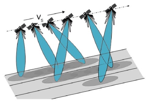
Sentinel-1 uses a cutting-edge SAR technique known as Terrain Observation with Progressive Scans SAR (TOPSAR).
TOPSAR enables the Extra Wide Swath (EW) and Interferometric Wide Swath (IW) modes and facilitates interferometric SAR. In these modes, bursts are synchronised from pass to pass to ensure the alignment of interferometric pairs. Interferometry uses more than one image of the same location to detect motion such as land deformation. Examples include studies of volcanoes, earthquakes, and sinkholes.
Intended to replace ScanSAR
TOPSAR mode is intended to replace the conventional ScanSAR mode, achieving the same coverage and resolution as ScanSAR, but with a nearly uniform Signal-to-Noise Ratio (SNR) and Distributed Target Ambiguity Ratio (DTAR).
Azimuth resolution is reduced compared to ScanSAR mode due to the shorter target illumination time of the burst. Using the sweeping azimuth pattern, each target is seen under the same antenna pattern, independently from its azimuth position in the burst image. By shrinking the azimuth antenna pattern, as seen by a target on the ground, scalloping effects on the image can be reduced. Bursts are synchronized from pass to pass to ensure the alignment of interferometric pairs.
For TOPSAR, the processing must handle the antenna steering rate and the DC rate due to the steering. The azimuth pre- and post-processing of the data must include deramping of the data prior to base-band DC estimation, azimuth ambiguity estimation, and GRD azimuth processing. Please see the technical note COPE-GSEG-EOPG-TN-14-0025 for details on how deramping is performed by the IPF.
TOPSAR azimuth antenna sweeping causes Doppler centroid variations of approximately 5.5 kHz introducing an azimuth phase ramp (azimuth fringes) for small co-registration errors. To correct this, azimuth co-registration is required to be better than 0.001 samples (pixels) in order to obtain phase error less than 3°.
To be useful for generating interferograms, TOPSAR bursts are synchronized between repeat-pass data takes. A burst synchronization of <5 ms is required.
Content on ASF’s Sentinel web pages is adapted from the European Space Agency (ESA) Sentinel Website.
Links in the table below open to ESA’s website for more information.
| SAR Mode | Interferometric Wide Swath (IW) | Extra Wide Swath (EW) |
|---|---|---|
| Details | Acquired with TOPSAR. Default mode over land; 250km swath width; 5m-x-20m ground resolution. | Acquired with TOPSAR using 5 sub-swaths instead of 3, resulting in lower resolution (20m-x-40m). Intended for maritime, ice, and polar-zone services requiring wide coverage and short revisit times. |
Image Quality
Users of Sentinel data may see quality issues similar to those below. Users are encouraged to submit examples of image-quality issues to [email protected].
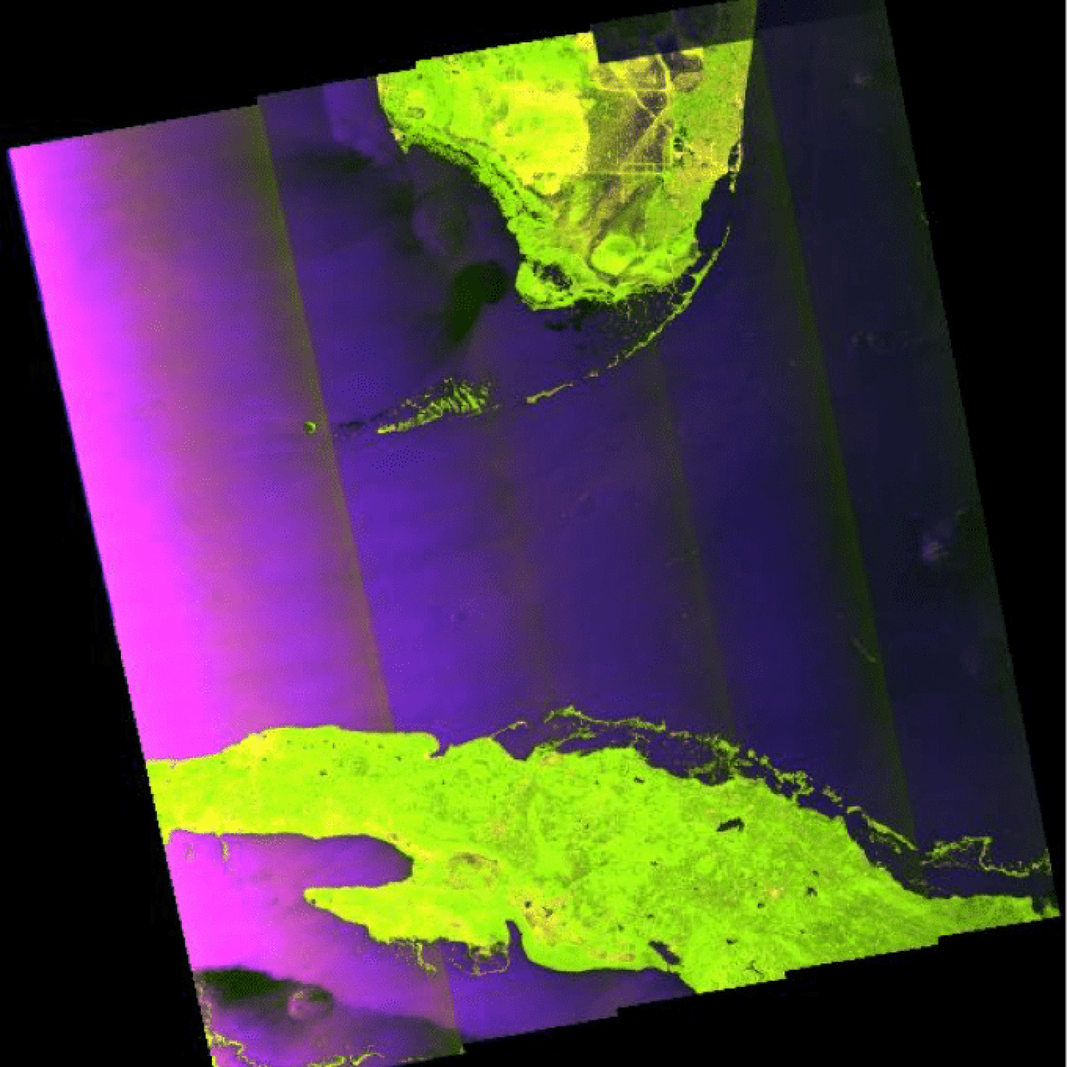
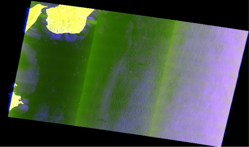
Browse images affected by map projection
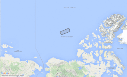
When an image granule is located above 65° latitude, the browse image can appear to be oriented and shaped differently than its outline in Vertex. The browse image is a geocoded JPEG displayed in a polar stereo map projection at latitudes above 65° in either hemisphere. The Vertex map always displays a granule in a Mercator projection. The examples show a Vertex map outline of a granule in the Arctic Ocean and an associated browse image. The browse image also is an example of stepped ends.
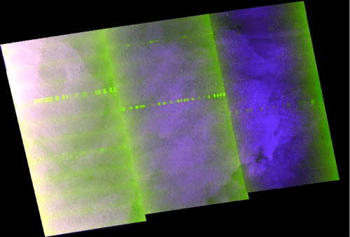
Images from data close to the noise floor
Images that contain a great deal of noise have often been processed close to the noise floor (the data closest to the point where it is too noisy to be useful). The noise can look like repeating lines across an image, something like horizontal window blinds, as in the left image below. Those repeating lines are not the same as the bright spots in these images, which appear in the image below and to the right as a line of repeated bright spots or bursts. Those bright bursts are image anomalies that are not yet well understood. Also visible in these images are beam seams (see the next section).
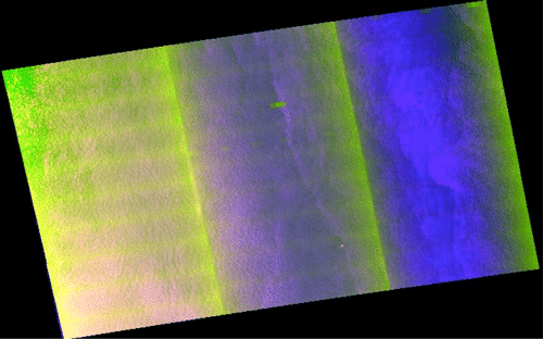
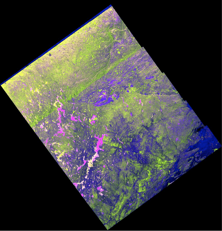
Beam seams
When one image is made up of several beams, the seams can show, particularly in dark data. Beam seams are visible in many of the images on this page, including the one to the right.
Offsets between channels
Beams that seem to have noisy or missing data at one end, such as the dark blue edge at the top of the image, have been processed in one channel more than another (such as the HV or VH channels).
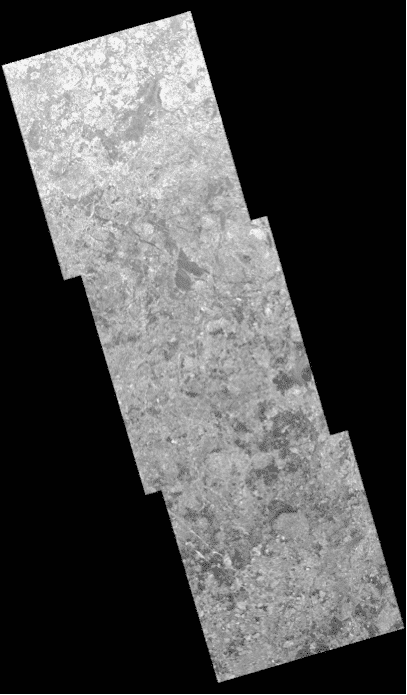
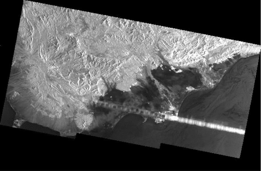
Stepped edges

Stepped ends, as in this image, are an artifact of the multi-beam scanning technology of TOPSAR and the way that ESA “slices” a data take into discrete, manageable units.
Bright burst
Bright bursts are processing anomalies that are not well understood. Bright bursts are in the upper left corner of the image below at left and in the light stripe across the image below right. Also visible in the image on the left are noise (window-blind effect), beam seams, and a bit of blue on the far left that may indicate an offset between channels.
Sentinel-1 Documents
| Name | Description |
|---|---|
| Product Specification Document, ASF | Defines the ISO-compliant XML metadata for ESA’s Sentinel-1A data. |
| Sentinel-1 SAR User Guide Introduction | High-level description of instrument modes and products. Also introduction to relevant application areas, information on data distribution, product formatting, and software tools available from ESA. |
| Sentinel-1 Technical Guide | Covers an in-depth description of the mission’s products and algorithms as well as details of the SAR instrument and its performance. |
| Sentinel High Level Observation Plan, Issue 2, Revision 1 | Provides the top-level operations plan of the Sentinel missions, including space and ground segments. |
| Sentinels POD Service File Format Specifications | Useful for InSAR. Users who consult this document may also want Precision State Vectors, available from ASF from 3 September 2015. The product handbook describes the products generated as part of the provisioning of the Copernicus POD Service. |
| Sentinel Document Library | The full document library is available on the ESA website. |
Sentinel-1 Tools
| Name | Description |
|---|---|
| ESA Sentinel App, for iOS and Android | Powerful visualization of Sentinel product availability. Track the satellites in real time over a 3D globe, see the last and next time they have been and will be over the user’s location, and more. |
| HyP3-ISCE2 | HyP3-ISCE2 is a burst-based Python package for creating burst InSAR products using ASF’s burst SLC products. This Python package can be installed and run locally, or burst InSAR products can be requested through HyP3, ASF’s on-demand processing tool. |
Sentinel-1 – Tutorials
- SAR Basics with the Sentinel-1 Toolbox
- Sentinel-1 Stripmap Interferometry
- Sentinel-1 TOPSAR Interferometry
- Radarsat-2 Interferometry
- SAR Polarimetry
- ALOS Orthorectification
Videos
- Sentinel-1 Toolbox Introduction
- Graph Building and Applying Radiometric Terrain-Flattening
- Stripmap Interferometry
Tutorials from the ESA Sentinel-1 Toolbox
Note: Tutorial materials that are about sensors other than Sentinel contain material relevant to Sentinel.
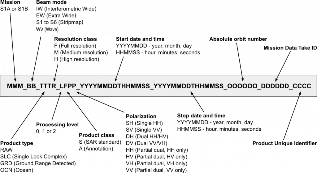
Naming Convention
The figure below illustrates the Sentinel-1 granule naming convention. For more information, see the Sentinel-1 Technical Guide.
Orbit Files and Auxilliary Data Files
The Precise Orbit Determination (POD) service for Sentinel-1 provides orbit ephemerides files in the form of Precise Orbit Ephemerides files (available 20 days after data acquisition) and Restituted Orbit files (available a few hours after data acquisition). Flight Operation Segment (FOS) Predicted Orbit files (available seven days before data acquisition), Instrument Processing Facility (IPF) auxiliary files, L1 Processor Parameters, L2 Processor Parameters, Instrument, Calibration, and Simulated Cross Spectra Auxiliary Data are also available.
Access to Sentinel-1 ephemeris files and documentation:
- Sentinel-1 Orbit Files are available from ASF
- Sentinel-1 Orbit Files are available from ESA
- ESA Sentinel-1 Quality Control document links
- COPERNICUS POD SERVICE FILE FORMAT SPECIFICATION
Guide to File Names
| IPF Auxiliary Data Files | Name |
|---|---|
| L1 Processor Parameters | aux_pp1 |
| Calibration Auxiliary Data | aux_cal |
| Instrument Auxiliary Data | aux_ins |
| L2 Processor Parameters | aux_pp2 |
| Orbit Files | Name |
|---|---|
| FOS Predicted Orbit | mpl_orbpre |
| POD Precise Orbit Ephemerides | aux_poeorb |
| POD Restituted Orbit | aux_resorb |
| POD Restitude Attitude | aux_resatt |
Content on ASF’s Sentinel web pages is adapted from the European Space Agency (ESA) Sentinel website.