

Observing Our Dynamic Planet
Tools to understanding local and global change

Welcome to the Dynamic Planet exhibition
The Alaska Satellite Facility (ASF) operates a satellite data-acquisition ground station and is the NASA Distributed Active Archive Center of synthetic aperture radar (SAR). The data are critical for the research of earth dynamics. These data provide a unique and striking way to view the earth and the earth’s features as they undergo change. Floods, earthquakes, and volcanic effects, sea ice fluctuation, coastline erosion, agriculture and forestry expansion and contraction: all these changes to the earth’s surface are either influenced by human activity and/or directly affect the lives of people living across the globe.
The core of the exhibit is a selection of more than 50 satellite and airborne data-derived images depicting landforms undergoing change over both short time periods (forests, agriculture, coastlines) and even shorter time periods (earthquakes, volcanoes, floods). The exhibit fosters an appreciation of the beauty of the earth, while celebrating the technology that allows us to have this 21st century view of the planet and how it is changing in ways both within and outside of our control. The exhibit topics allow for a range of hands-on and digital interactive possibilities from operating a model of a satellite ground station, to moving through image time series highlighting particular locations around the globe.
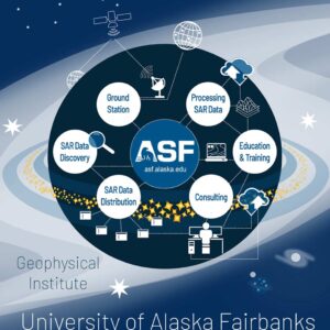
ASF Overview
The Alaska Satellite Facility (ASF), a component of the Geophysical Institute at the University of Alaska Fairbanks, manages NASA’s archive of Synthetic Aperture Radar (SAR) data in support of the Earth Science Data and Information System (ESDIS) project.
ASF is responsible for the downlinking, processing, archiving, and global distribution of remote-sensing data to the scientific community. The facility actively promotes and advances the use of remote sensing to support Earth science research, field operations, and commercial applications at both national and international levels. Dedicated to excellence, ASF is committed to delivering high-quality data and responsive services to researchers and users worldwide.
What is SAR
Synthetic Aperture Radar (SAR) and Interferometric Synthetic Aperture Radar (InSAR) are advanced remote sensing technologies that have revolutionized our ability to observe and analyze the Earth’s surface with unprecedented precision and detail. These technologies utilize radar signals to create high-resolution images and generate topographic information, offering researchers, scientists, and various industries invaluable insights into a wide range of natural and anthropogenic phenomena.
How SAR works
SAR works by transmitting microwave pulses towards the Earth’s surface and measuring the echoes that bounce back. Unlike optical sensors, SAR is not reliant on sunlight, which means it can operate effectively regardless of weather conditions or time of day. This makes it a powerful tool for continuous monitoring and data acquisition in various environments, from urban landscapes to dense forests and even polar regions.


Benefits of SAR
The benefits of using SAR and InSAR in research are multifaceted and profound. These technologies offer a synoptic view of Earth’s surface changes, enabling comprehensive assessments of large areas that would be impractical to cover using traditional ground-based methods. This capacity is particularly useful for monitoring regions prone to environmental degradation, urban expansion, and ecosystem alterations.
SAR and InSAR provide researchers with temporal data, allowing them to track changes over time and uncover trends that might otherwise go unnoticed. For instance, by analyzing long-term deformation patterns, scientists can gain insights into the behavior of fault lines or anticipate the development of geological hazards, contributing to enhanced disaster preparedness and mitigation.
The role of SAR and INSAR
SAR and InSAR play a crucial role in addressing global challenges like climate change. They aid in monitoring glacier movements, ice sheet dynamics, and sea level rise, providing valuable data for understanding the impact of temperature changes on polar regions and contributing to more accurate climate models.
In research domains such as agriculture, forestry, and hydrology, these technologies facilitate precision monitoring of crop health, deforestation rates, and changes in water bodies. This information can guide sustainable resource management practices and support informed decision-making.


New frontiers
In conclusion, SAR and InSAR technologies have opened new frontiers in Earth observation and scientific research. Their ability to capture detailed, near-real-time data over large areas, coupled with their applications across various disciplines, offers a powerful means to study and address complex challenges facing our planet. As these technologies continue to evolve, their impact on advancing our understanding of natural processes and human activities is likely to grow, paving the way for more informed and effective strategies for environmental stewardship and sustainable development.
Earthquake
SAR data is pivotal in earthquake monitoring due to its ability to detect ground displacement. By comparing pre- and post-earthquake SAR images, even subtle surface shifts can be identified. InSAR techniques precisely measure these changes, creating “interferograms” that highlight deformation patterns. This data aids in mapping fault lines, identifying areas of potential seismic activity, and assessing earthquake impacts on infrastructure. SAR’s all-weather and day-night capabilities provide continuous monitoring, crucial for disaster response and mitigation efforts. In essence, SAR offers a high-resolution, timely, and comprehensive perspective on seismic events, empowering experts to make informed decisions.
Coastline
SAR data is instrumental in monitoring coastal erosion due to its ability to capture large-scale changes over time. By comparing SAR images acquired at different periods, experts can detect shifts in shoreline position and track the rate of erosion. This data aids in assessing vulnerability and formulating strategies for coastal protection. SAR’s consistent imaging, regardless of weather or light conditions, provides reliable insights into erosion patterns and impacts. In essence, SAR enables timely and accurate assessment of coastal dynamics, facilitating effective management and mitigation of erosion-related challenges.
Time Series
A SAR time series is an invaluable resource for a wide range of applications. By capturing high-resolution images of the Earth’s surface at different time points, SAR time series enable us to monitor and analyze dynamic processes and changes over time. This technology is particularly useful for tasks like land cover change detection, deformation monitoring (such as subsidence or landslides), and crop growth analysis. SAR’s ability to penetrate cloud cover and provide consistent data regardless of weather conditions makes it a reliable tool for monitoring environmental changes, urban development, infrastructure integrity, and natural disasters. Moreover, SAR time series can assist in disaster management, offering critical insights for early warning systems and post-disaster assessment. Its applications span multiple sectors, including agriculture, forestry, geology, and urban planning, making it an indispensable resource for understanding and addressing various Earth-related challenges.