Sentinel-1 Bursts

ASF offers derived burst-based products for Sentinel-1 single look complex (SLC) data collected via the Interferometric Wide (IW) mode and Extra-Wide Swath (EW) modes*. These products are particularly useful for scientists interested in obtaining data for small geographic areas and workflows requiring precise alignment of co-geolocated SLC data through time (i.e., time series analyses). For more information on the Sentinel-1 mission, see ASF’s Sentinel-1 dataset page. Content on the ASF web page is adapted from the ESA Sentinel-1 website. Sentinel-1 data, including burst data, are provided under NASA’s provision of the ESA Sentinel-1 data archive through ASF.
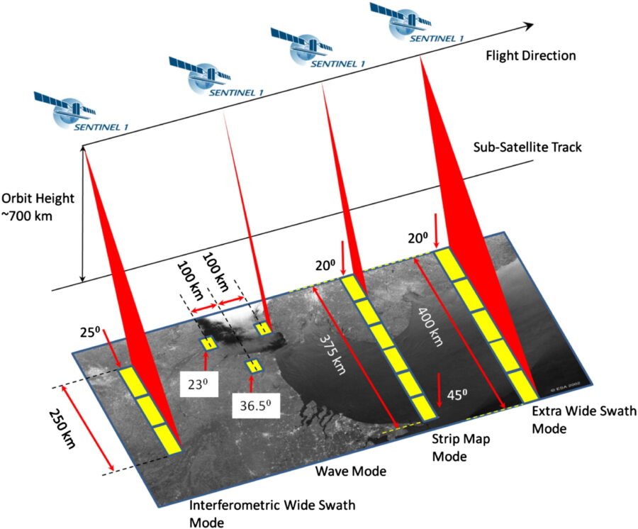
Illustration from Sentinel Online, European Space Agency (ESA)


Overview
Sentinel-1 Interferometric Wide (IW) mode and Extra-Wide Swath (EW) mode single look complex (SLC) data are collected using a form of ScanSAR imaging called Terrain Observation with Progressive Scans SAR (TOPSAR). In these modes, data is collected by cyclically observing, then switching the antenna beam between multiple adjacent sub-swaths. Within each observation of a sub-swath, a short sequence of radar pulses are transmitted in rapid succession, imaging a contiguous portion of the target surface. These short sequences of radar pulses are called “bursts”, and are the fundamental unit of SLC data collected using the TOPSAR technique.
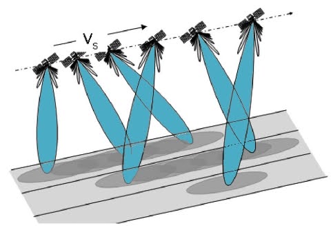
Illustration from Sentinel Online, ESA
Data from many bursts are packaged together to create the standard Sentinel-1 IW and EW SLC products. These products are produced by creating sub-swath images that contain a series of overlapping bursts, where each burst has been processed as a separate SLC image. Sub-swath images from all available swaths (three swaths for IW mode and five swaths for EW mode) are packaged together to create the final SLC products. While data from many bursts are packaged together in the standard SLC products, SLC data from a single burst can be utilized independently.
To enable single-burst applications, ASF has developed an extraction service that allows users to download single-burst IW and EW SLC products. The burst SLC data are available as a GeoTIFF and supplemental metadata files from the parent SLC product are available as a single XML file.
| Dataset Property | Interferometric Wide Beam Mode | Extra-Wide Beam Mode |
|---|---|---|
| Temporal Coverage | 12 Days | 12 Days |
| Spatial Coverage | Global | Global |
| Center Frequency | C-band at 5.405 GHz | C-band at 5.405 GHz |
| Polarization | Single Polarization (HH or VV) Dual Polarization (HH+HV or VV+VH) | Single Polarization (HH or VV) Dual Polarization (HH+HV or VV+VH) |
| Spatial Resolution | 5 x 20 m | 20 x 40 m |
| Swath Width | 85 km | 85 km |
| Off-Nadir Angle | 29.1° to 46.0° | 18.9° to 47.0° |
| Download info | Data Discovery | Data Discovery |
| File format | GeoTIFF | GeoTIFF |
| Provider | European Space Agency | European Space Agency |
| Date published: | June 2023 | June 2023 |
Expand the sections below to view content. Access the full content on a single page by clicking the button.
User Guides/Technical Information
Instrument information
Launches:
- Sentinel-1B: Soyuz rocket, launched 25 April 2016, from Kourou, French Guiana
- Sentinel-1A: Soyuz rocket, launched 3 April 2014, from Kourou, French Guiana
Orbit: Polar, sun-synchronous at an altitude of 693 km
Revisit time: Six days with two-satellite constellation of Sentinel-1A and 1B. Before 1B launched, revisit time for Sentinel-1A alone was 12 days.
Instrument: C-band synthetic aperture radar (SAR) at 5.405 GHz
- Interferometric wide-swath (IW) at 250 km and 5×20 m resolution, using TOPSAR
- Wave (WV) images of 20×20 km and 5×5 m resolution (at 100 km intervals)
- Stripmap (SM) at 80 km swath and 5×5 m resolution
- Extra wide swath (EW) of 400 km and 20×40 m resolution, using TOPSAR
- Supports operation in single polarization (HH or VV) and dual polarization (HH+HV or VV+VH)
- Polarization implemented through one transmit chain (switchable to H or V) and two parallel receive chains for H and V polarization
- SM, IW and EW are available in single (HH or VV) or dual polarization (HH+HV or VV+VH)
- WV is single polarization only (HH or VV)
Receiving stations: SAR data: Svalbard, Norway; Matera, Italy; Maspalomas, Spain; and via laser link through EDRS (European Data Relay System)
Telemetry, tracking and command: via Kiruna, Sweden
Main applications: Monitoring sea ice, oil spills, marine winds and waves, land-use change, land deformation, and to respond to emergencies such as floods and earthquakes
Mission: Developed, operated, and managed by various ESA establishments
Life: Minimum of seven years
Satellites: 2.8 m long, 2.5 m wide, 4 m high with 2×10 m-long solar arrays and a 12 m-long radar antenna
Mass: 2300 kg (including 130 kg fuel)
Funding: ESA Member States and the European Union Prime contractors: Thales Alenia Space, Italy, for the satellite; Airbus Defence and Space, Germany, for the SAR instrument
Content on ASF’s Sentinel web pages is adapted from the European Space Agency (ESA) Sentinel website.
Links in the table below open to ESA’s website for more information.
| SAR Mode | Interferometric Wide Swath (IW) | Extra Wide Swath (EW) |
|---|---|---|
| Details | Acquired with TOPSAR. Default mode over land; 250km swath width; 5m-x-20m ground resolution. | Acquired with TOPSAR using 5 sub-swaths instead of 3, resulting in lower resolution (20m-x-40m). Intended for maritime, ice, and polar-zone services requiring wide coverage and short revisit times. |
Single-burst SLC datasets are virtual datasets, meaning that they are not extracted until a user requests them. For developers wishing to interact directly with the extractor application program interface (API) that is responsible for creating these datasets, documentation on the extractor API can be found at https://sentinel1-burst-documentation.asf.alaska.edu.
Image Quality
Users of Sentinel data may see quality issues similar to those below. Users are encouraged to submit examples of image-quality issues to [email protected].
Images from data close to the noise floor
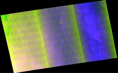
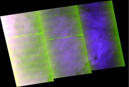
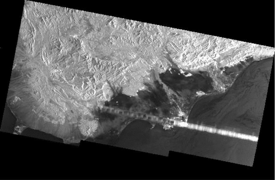
Images that contain a great deal of noise have often been processed close to the noise floor (the data closest to the point where it is too noisy to be useful). The noise can look like repeating lines across an image, something like horizontal window blinds, as in the left image below. Those repeating lines are not the same as the bright spots in these images, which appear in the image below and to the right as a line of repeated bright spots or bursts. Those bright bursts are image anomalies that are not yet well understood. Also visible in these images are beam seams (see the next section).
Empty heading
Beam seams
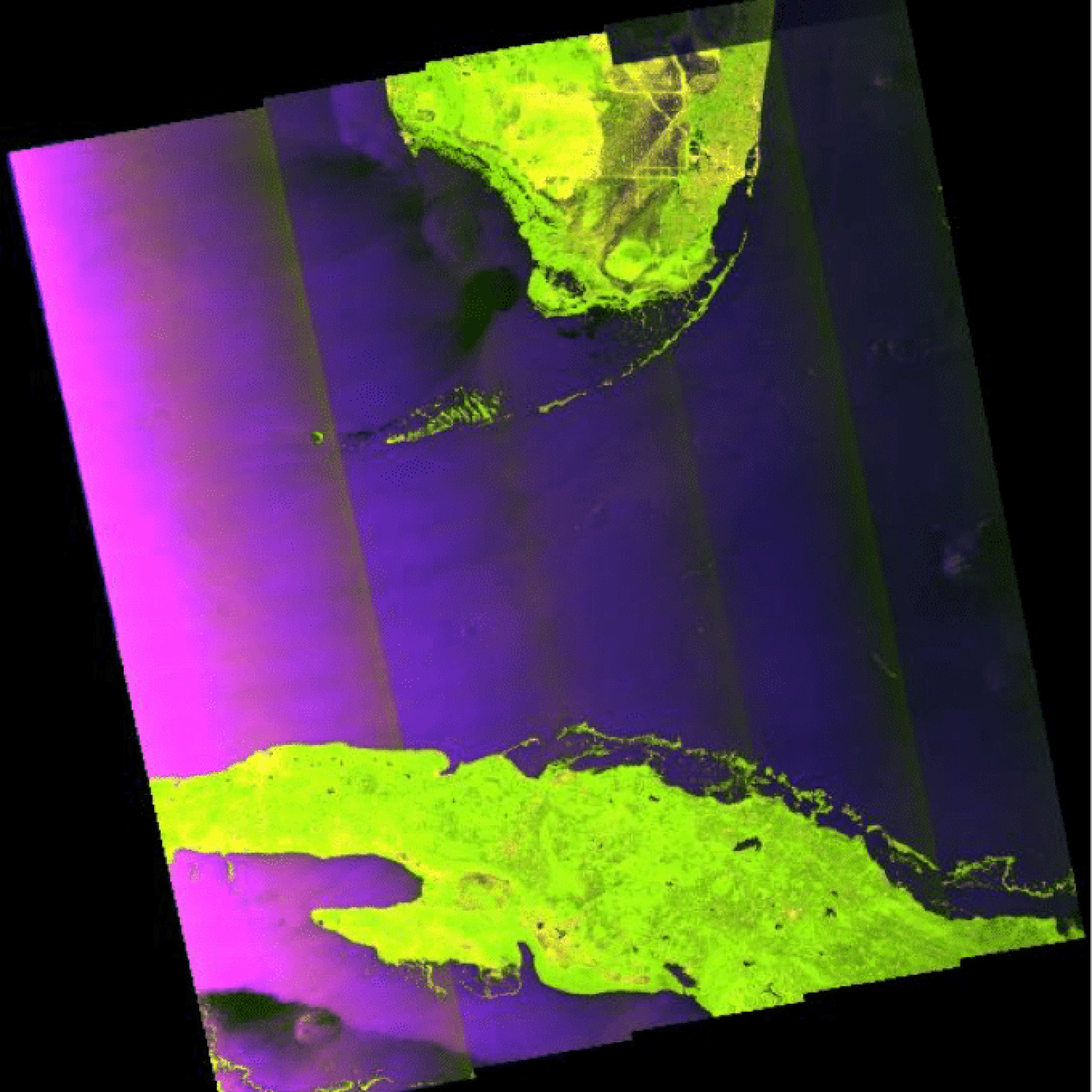
When one image is made up of several beams, the seams can show, particularly in dark data. Beam seams are visible in many of the images on this page, including the one to the right.
Empty heading
Offsets between channels
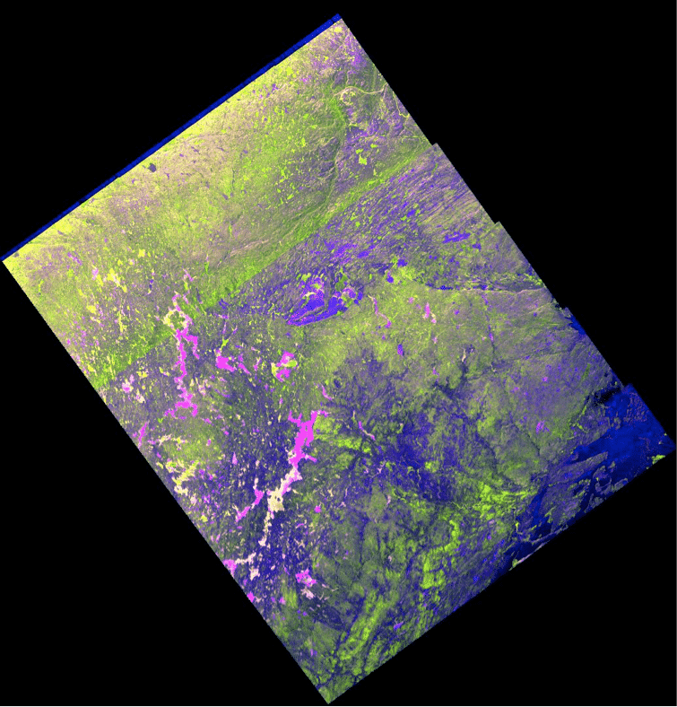
Beams that seem to have noisy or missing data at one end, such as the dark blue edge at the top of the image, have been processed in one channel more than another (such as the HV or VH channels).
Stepped edges
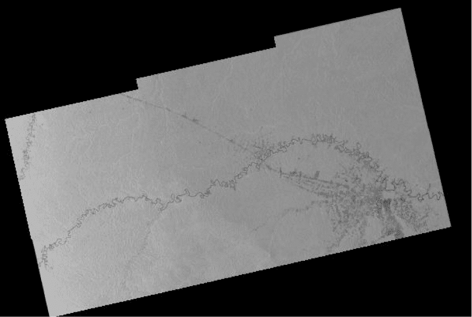
Stepped ends, as in this image, are an artifact of the multi-beam scanning technology of TOPSAR and the way that ESA “slices” a data take into discrete, manageable units.
Bright burst
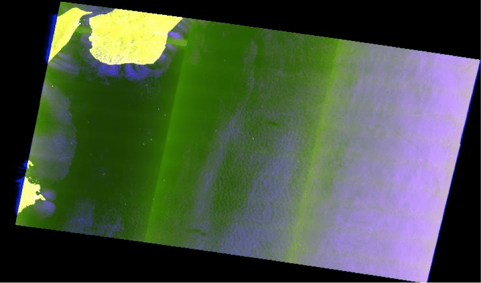
Bright bursts are processing anomalies that are not well understood. Bright bursts are in the upper left corner of the image below at left and in the light stripe across the image below right. Also visible in the image on the left are noise (window-blind effect), beam seams, and a bit of blue on the far left that may indicate an offset between channels.
Sentinel-1-Documents
Links and descriptions for key Sentinel-1 documents| Name | Description |
|---|---|
| Product Specification Document, ASF | Defines the ISO-compliant XML metadata for ESA’s Sentinel-1A data. |
| Sentinel-1 SAR User Guide Introduction | High-level description of instrument modes and products. Also introduction to relevant application areas, information on data distribution, product formatting, and software tools available from ESA. |
| Sentinel-1 Technical Guide | Covers an in-depth description of the mission’s products and algorithms as well as details of the SAR instrument and its performance. |
| Sentinel High Level Observation Plan, Issue 2, Revision 1 | Provides the top-level operations plan of the Sentinel missions, including space and ground segments. |
| Sentinels POD Service File Format Specifications | Useful for InSAR. Users who consult this document may also want Precision State Vectors, available from ASF from 3 September 2015. The product handbook describes the products generated as part of the provisioning of the Copernicus POD Service. |
| Sentinel Document Library | The full document library is available on the ESA website. |
Sentinel-1-Tools
links and descriptions for key Sentinel-1 tools| Name | Description |
|---|---|
| ESA Sentinel App, for iOS and Android | Powerful visualization of Sentinel product availability. Track the satellites in real time over a 3D globe, see the last and next time they have been and will be over the user’s location, and more. |
| HyP3-ISCE2 | HyP3-ISCE2 is a burst-based Python package for creating burst InSAR products using ASF’s burst SLC products. This Python package can be installed and run locally, or burst InSAR products can be requested through HyP3, ASF’s on-demand processing tool. |
Burst SLC products
Burst SLC products are virtual i.e., they are created on-demand whenever a user makes a download request for a given product. The burst SLC data products are created by extracting the portion of SLC data corresponding to a given burst from the parent swath SLC file in the SLC SAFE archive. Information on where each burst is located within the parent swath SLC file is obtained from the annotation metadata files that are also found within the SLC SAFE archive. The data undergoes only one alteration post-extraction: setting burst data to zero (the data’s NoData value) in regions marked as invalid. The invalid region is defined using the firstValidSample, and lastValidSample fields found within the burst sections of the annotation metadata files. For more information on these fields, we refer you to the Sentinel-1 Product Specification Document. This operation is performed to ensure compatibility with existing SAR processors that expect invalid regions to already be removed when ingesting burst SLC data. Once this operation is complete, the burst SLC data is written to a GeoTIFF file and is distributed to the user.
Burst Metadata Files
The burst metadata files were constructed by combining all of the metadata xml files found in the burst’s parent SAFE file that share a polarization with the burst. This includes the annotation, noise, rfi, and calibration metadata files for all swaths. We made the decision to include metadata for all swaths, because we are aware of some workflows that require metadata from neighboring bursts. We made an effort to modify the original metadata files as little as possible, and instead chose to combine the original metadata file contents in a single file.
The XML structure combines separate manifest, product, noise, rfi, and calibration files into a single format. The root element, “burst,” includes a “manifest” element that contains the parent SAFE manifest file. The “metadata” section contains “product”, “noise”, “rfi”, and “calibration” elements, each encapsulating content from the respective original XML files. For example, the “product” sections include the annotation xml file contents from the parent SAFE. As noted above, this metadata file contains data from one polarization and one swath so there will be three “product” elements for IW bursts, and five for EW bursts. This consolidation simplifies data retrieval, providing an organized and unified representation of information that was previously distributed across individual XML files.
burst
    manifest: ORIGINAL_XML
    metadata
        product
            swath
            polarisation
            content: ORIGINAL_XML
        noise
            swath
            polarisation
            content: ORIGINAL_XML
        rfi
            swath
            polarisation
            content: ORIGINAL_XML
        calibration
            swath
            polarisation
            content: ORIGINAL_XML
        {STRUCTURE ABOVE REPEATED FOR EACH SWATH}
Sentinel-1 Bursts Data
Cite datasets in publications such as journal papers, articles, presentations, posters, and websites. For more information, see Terms and Conditions. Please send copies of, or links to, published works citing data, imagery, or tools accessed through ASF to [email protected] with “New Publication” on subject line.
| Type | Format | Example |
|---|---|---|
| Primary Data | Copernicus Sentinel data [year of data acquisition]. Retrieved from ASF DAAC [day month year of data access], processed by ESA. | Copernicus Sentinel data [year of data acquisition]. Retrieved from ASF DAAC [day month year of data access], processed by ESA. |
| Modified Data | [creator credit, year created], contains modified Copernicus Sentinel data [year of data acquisition], processed by ESA. | ASF DAAC 2015, contains modified Copernicus Sentinel data 2015, processed by ESA. |
Sentinel-1 Imagery
Include appropriate credit with each image shown in publications such as journal papers, articles, presentations, posters, and websites.
| Type | Format | Example |
|---|---|---|
| Primary Data | Copernicus Sentinel data [year of data acquisition], processed by ESA. | Copernicus Sentinel data 2015, processed by ESA. |
| Modified Data | [creator credit, year created], contains modified Copernicus Sentinel data [year of data acquisition], processed by ESA. | ASF DAAC 2015, contains modified Copernicus Sentinel data 2015, processed by ESA. |
Sentinel legal notice with Terms and Conditions
European Space Agency Legal Notice on the Use of Copernicus Sentinel Data and Service Information
The access and use of Copernicus Sentinel Data and Service Information is regulated under EU law.1 In particular, the law provides that users shall have a free, full and open access to Copernicus Sentinel Data2 and Service Information without any express or implied warranty, including as regards quality and suitability for any purpose.3
EU law grants free access to Copernicus Sentinel Data and Service Information for the purpose of the following use in so far as it is lawful4 :
(a) reproduction;
(b) distribution;
(c) communication to the public;
(d) adaptation, modification and combination with other data and information;
(e) any combination of points (a) to (d).
EU law allows for specific limitations of access and use in the rare cases of security concerns, protection of third party rights or risk of service disruption.
By using Sentinel Data or Service Information the user acknowledges that these conditions are applicable to him/her and that the user renounces to any claims for damages against the European Union and the providers of the said Data and Information. The scope of this waiver encompasses any dispute, including contracts and torts claims, that might be filed in court, in arbitration or in any other form of dispute settlement.
Where the user communicates to the public or distributes Copernicus Sentinel Data and Service Information, he/she shall inform the recipients of the source of that Data and Information by using the following notice5 :
- ‘Copernicus Sentinel data [Year]’ for Sentinel data; and/or
- ‘Copernicus Service information [Year]’ for Copernicus Service Information.
Where the Copernicus Sentinel Data and Service Information have been adapted or modified, the user shall provide the following notice:
- ‘Contains modified Copernicus Sentinel data [Year]’ for Sentinel data; and/or
- ‘Contains modified Copernicus Service information [Year]’ for Copernicus Service Information.
The users’ rights on their personal data are protected under European law6. Such data will only be used by the European Commission and the providers of the said Data and Information for providing services to the user and for statistical as well as evaluation purposes.
1 Regulation (EU) No 377/2014 and Commission Delegated Regulation (EU) No 1159/2013.
2 In agreement with the Copernicus Sentinel Data Policy, ESA/PB-EO(2013)30, rev. 1.
3 See in particular Art. 3 and 9 of Regulation 1159/2013.
4 See in particular Art. 7 of Regulation 1159/2013.
5 See in particular Art. 8 of Regulation 1159/2013.
6 Directive 95/46/EC of the European Parliament and of the Council of 24 October 1995 on the protection of individuals with regard to the processing of personal data and on the free movement of such data; Regulation (EC) No 45/2001 (EC) No 45/2001 of the European Parliament and of the Council of 18 December 2000 on the protection of individuals with regard to the processing of personal data by the Community institutions and bodies and on the free movement of such data.
Data Discovery
Users can download Sentinel-1 Burst data from the NASA-sponsored ASF DAAC.
Data Discovery Tools
| Data Discovery Tool | Link |
|---|---|
| ASF Vertex Data Search | Vertex |
| Python Search Module | asf_search |
| ASF Search API | ASF Search API |
| NASA Earthdata Search | Earthdata Search |


