

UAVSAR
Uninhabited Aerial Vehicle Synthetic Aperture Radar (UAVSAR), a Jet Propulsion Laboratory (JPL)-built reconfigurable, polarimetric L-band synthetic aperture radar (SAR), is specifically designed to acquire airborne repeat-track SAR data for differential interferometric measurements.
The radar is designed to be operable on a UAV (Uninhabited Aerial Vehicle) but will initially be demonstrated on a NASA Gulfstream III. The radar is fully polarimetric, with a range bandwidth of 80 MHz (2-m range resolution) and a range swath greater than 16 km.
The data are open access — no proposal is required.
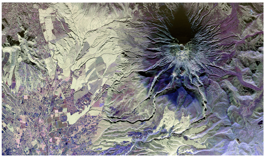
Image: UAVSAR Pauli decomposition of Cotopaxi volcano, Ecuador. Image by NASA /JPL
Overview
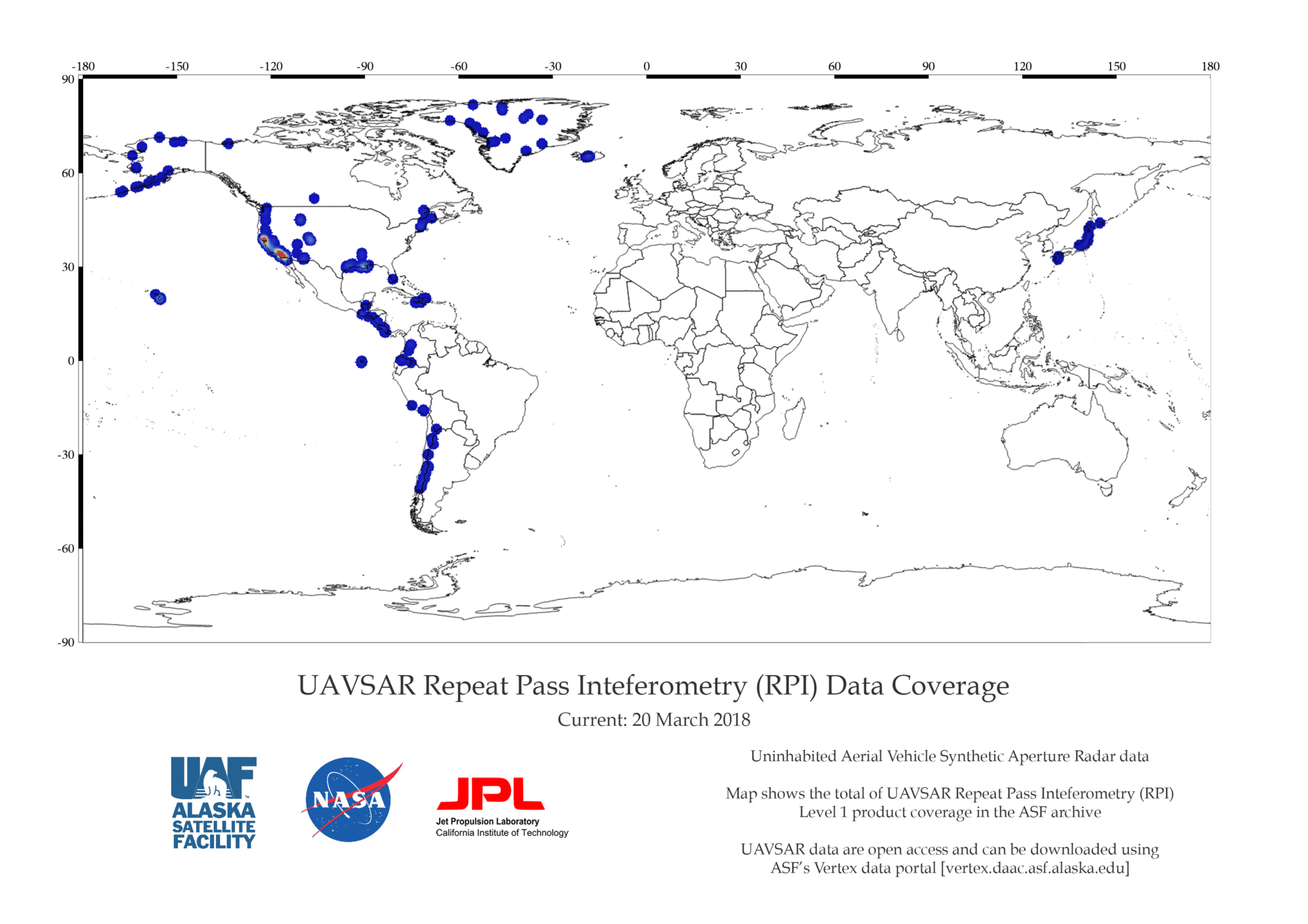
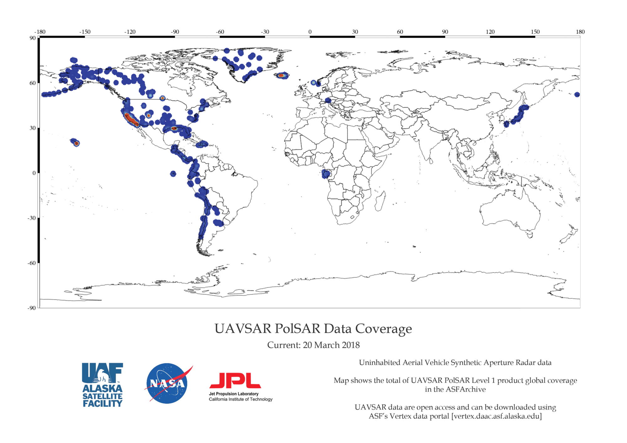
Airborne SAR — synthetic aperture radar 2008-present Locations: portions of North America; Greenland; Iceland; and North, Central, and South America Polarimetric L-band and interferometric products Downloadable Products: PolSAR — polarimetric SAR MLC, Compressed Stokes Matrix, Ground Projected Complex, Pauli Decomposition RPI — repeat pass interferometry Interferogram, Ground Projected Interferogram, Amplitude, Ground Projected Amplitude More information is available at the JPL UAVSAR website.
| Dataset Property | Value |
|---|---|
| Temporal Coverage | 2008-present |
| Spatial Coverage | Portions of North America; Greenland; Iceland; and North, Central, and South America |
| Polarization | Full |
| Frequency | L-band |
| Spatial Resolution | 1.8 m |
| Swath Width | 16 km |
| Download info | Data Discovery |
| Provider | Jet Propulsion Laboratory |
| Date published: | 2008-present |
Expand the sections below to view content. Access the full content on a single page by clicking the button.
User Guide and Technical Information

Read more on the JPL UAVSAR Website
UAVSAR Products
Downloadable Products:
- PolSAR — polarimetric SAR
- MLC, Compressed Stokes Matrix, Ground Projected Complex, Pauli Decomposition
- RPI — repeat pass interferometry
- Interferogram, Ground Projected Interferogram, Amplitude, Ground Projected Amplitude
More information is available at the JPL UAVSAR website.
How to Cite UAVSAR Data and Imagery
Cite data in publications such as journal papers, articles, presentations, posters, and websites. Please send copies of, or links to, published works citing data, imagery, or tools accessed through ASF to [email protected] with “New Publication” on subject line.
Include credit with each image shown in publications such as journal papers, articles, presentations, posters, and websites. (NASA does not copyright imagery.)
| Type of Dataset | Format | Example |
|---|---|---|
| UAVSAR Data | Dataset: UAVSAR, NASA [year of data acquisition]. Retrieved from ASF DAAC [day month year of data access]. | Dataset: UAVSAR, NASA 2011. Retrieved from ASF DAAC 7 June 2015. |
| UAVSAR Imagery | NASA [year of data acquisition] | NASA 2008 |
UAVSAR DOIs
| Dataset | DOI |
|---|---|
| UAVSAR_POLSAR | 10.5067/7PEQV8SVR4DM |
| UAVSAR_RPI | 10.5067/R0ARICRBAKYE |
Discover UAVSAR products
UAVSAR products can be accessed at ASF DAAC:
Data Discovery Tools
| Data Discovery Tool | Link |
|---|---|
| ASF Vertex Data Search | Vertex |
| Python Search Module | asf_search |
| ASF Search API | ASF Search API |
| NASA Earthdata Search | Earthdata Search |
Learn more about ASF Data Discovery Services