

The radiometric terrain correction (RTC) stack processor tool facilitates time-series analysis of such phenomena as flooding events, deforestation, or glacier retreat.
This tool creates a stack from a set of Sentinel-1 RTC products produced on the ASF HyP3 system. It also works for a co-registered set of PALSAR RTC products. In fact, the tool can accept any UTM-projected co-registered set of images.
The stacking tool allows the user to perform sub-setting, resampling, grouping, filtering and culling on the stack. The final products are a stack of processed GeoTIFF and an animated GIF of the stack.
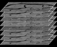
A stack of Sentinel-1 RTC scenes over the Yukon river flats region near Beaver, Alaska. Contains modified Copernicus Sentinel data 2017-2018, processed by ESA
Stack Processor Instructions Overview
Input Options
- Download input files from a HyP3 subscription (if not already downloaded), unzipping files as necessary.
- Process cloud-optimized images directly from an AWS bucket
- Read unzipped HyP3 directories or custom files from the command line
Processing Options
- Group files by timestamp
- Ascending or descending only
- Subset images by clipping to:
- Common overlap
- Bounding box
- Shapefile
- Cull images based on the amount of ‘no data.’
- Filter images using the Enhanced Lee filter
- Resample image to the desired resolution
Post Processing
- Animation creation
- Results are scaled to byte using a set dB range
- Results converted to PNG files
- HyP3 files annotated with the date
- Create an animated GIF from PNG files
- Output frames
- Clipped groups of processed images are converted to one of these:
- dB byte
- dB float
- Floating point amplitude
- Floating point power
- Clipped groups of processed images are converted to one of these: