

ASF’s Radiometric Terrain Correction Project
The creation of radiometric terrain corrected (RTC) products was a project of the Alaska Satellite Facility to make SAR data accessible to a broader community of users. RTC removes the geometric and radiometric distortions inherent in synthetic aperture radar (SAR) and the corrected PALSAR data are provided in a GIS-compatible GeoTIFF format.
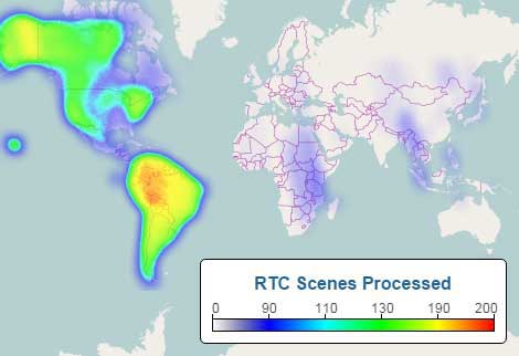
The release of ALOS PALSAR RTC products commenced in October 2014 and was completed a year later. Data used in the RTC project were Fine Beam (FBS, FBD) and Polarimetric (PLR) scenes over all global land areas except Antarctica, Greenland, Iceland, and northern Eurasia.
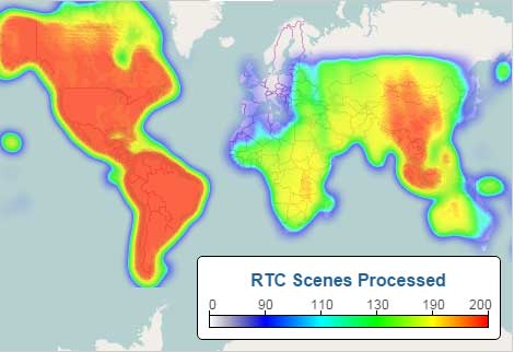
Extent and concentration of processed RTC scenes by beam mode| Total | FBS | FBD | PLR |
|---|---|---|---|
 |  |  |  |
ALOS PALSAR RTC Documentation
| Name | Description |
|---|---|
| RTC Product Guide (2015) | Guide for radiometrically terrain-corrected products. |
| RTC Product Specification (2014) | This product format specification defines standard terrain-corrected products generated at ASF. It contains the definition for the ISO-compliant XML metadata. |
| RTC ATBD (2015) | Algorithm Theoretical Basis Document: Provides the theoretical background of the algorithms and processing flows used for the generation of terrain-corrected products processed by ASF. |
Radiometric Correction
Radiometric correction involves removing the influence of topography on radar backscatter values. For example, radiometric correction removes the exaggerated brightness caused by radar reflection from steep ground surfaces facing the satellite or aircraft.
Terrain Correction
Terrain correction is correcting geometric distortions introduced by side-looking radar imaging that lead to geolocation errors. These distortions are compounded by rugged terrain. Terrain correction moves image pixels into the proper spatial relationship with each other and the ground. Mountains that look like they have fallen toward the sensor are repositioned to their correct shape and geolocation.
Correction of geometric distortion is sometimes called orthorectification, most commonly used when referring to optical imagery.
Radiometric Terrain Correction
Radiometric terrain correction combines both corrections to produce a superior product for science applications.
PALSAR RTC DEM Information and Disclaimer
The Digital Elevation Model (DEM) file in the ALOS PALSAR Terrain Corrected product package is not generated from the PALSAR data. It is a copy of an existing DEM modified and used for the radiometric terrain correction process. The pixel spacing of the source DEM was adjusted to match that of the Terrain Corrected image it is packaged with and does not indicate the DEM’s resolution.
The source DEMs used for the ALOS PALSAR Terrain Corrected products are from either the Shuttle Radar Topography Mission (SRTM) or the National Elevation Dataset (NED). Refer to the table and map in the section About the source DEMs used for ALOS PALSAR RTC processing to determine the native resolution and spatial coverage of the source DEMs used for the project.
The source-DEM tiles needed to cover the spatial extents of an uncorrected PALSAR scene were downloaded and mosaicked into a single DEM raster. This mosaicked DEM was processed to apply a geoid correction (see Fig. 1) and then resampled to match the output pixel spacing of the PALSAR scene.
The DEM files packaged with the RTC products are only intended to be used as a reference for evaluating the radiometric terrain correction process. They should not be used in place of a regular DEM, as the geoid correction in preparation for RTC processing alters the elevation values.
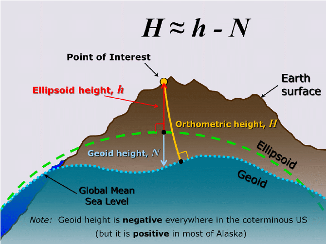 Figure 1. Most DEMs are geoid-based and require a conversion before they can be used for terrain correction. The DEM included with an ASF RTC product was converted from the orthometric height of the source DEM to ellipsoid height using the ASF MapReady geoid_adjust tool. This tool applies a geoid correction so that the resulting DEM relates to the ellipsoid.
The GeoidEval Utility is a free online tool that computes the height of the geoid above the WGS84 ellipsoid at a specific location and will show the correction applied to the source DEM used in creating an RTC product.
About the source DEMs used for ALOS PALSAR RTC processing
The quality of an ALOS PALSAR RTC product is directly related to the quality of the digital elevation model (DEM) used in the radiometric terrain correction (RTC) process. The map indicates which DEM was used in a given location, and the table below summarizes the various DEM sources.
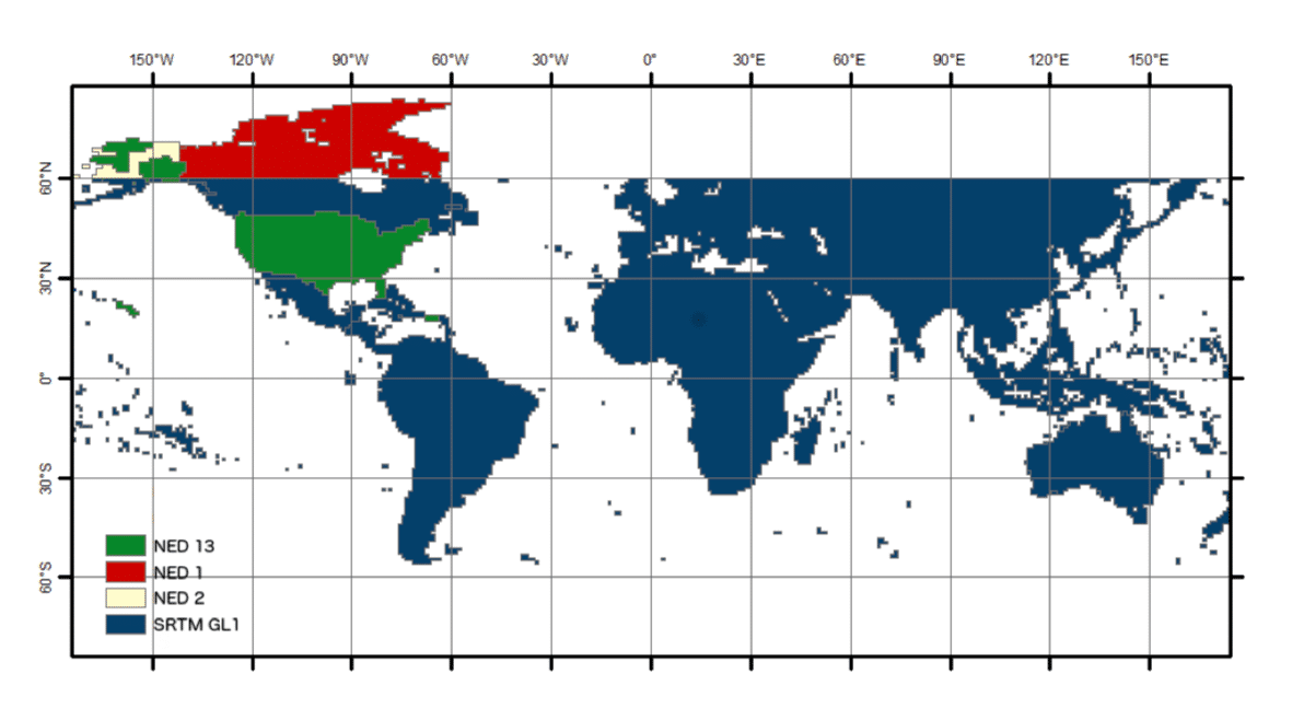
The continental U.S. (CONUS), Hawaii, and parts of Alaska are covered with a 1⁄3 arc-second National Elevation Dataset (NED) at a 10 m resolution. The rest of Alaska above 60 degrees north latitude was only available at 60 m resolution with two arc-second NED data. One arc-second NED provided the best resolution for Canada and Mexico at 30 m. The Shuttle Radar Topography Mission (SRTM) GL1 data at one arc-second (30 m) resolution was used for the remaining globe. Greenland and Antarctica, mostly covered by ice and glaciers, were not terrain or radiometrically corrected. No suitable DEMs were available for areas in Eurasia above 60 degrees north latitude.
ASF pre-processed the DEMs to a consistent raster format (GeoTIFF) from the source formats: height (*.hgt), ESRI ArcGrid (*.adf), etc. Many NASA-provided DEMs were provided as orthometric heights with EGM96 vertical datum. These were converted to ellipsoid heights using the ASF MapReady tool named geoid_adjust. The pixel reference varied from the center (pixel as point) to a corner (pixel as area). The GAMMA software, used to generate the terrain-corrected products, uses pixels as area and adjusts DEM coordinates as needed. Where more than one DEM was available, the best-resolution DEM was processed. Complete DEM coverage from a single DEM source was a requirement for processing to proceed.
DEMs used for ALOS PALSAR RTC processing
| Name | Datum | Spatial Coverage | DEM Resolution |
|---|---|---|---|
| NED13 | NAVD88 | CONUS, Hawaii, parts of Alaska | ~10m (1/3 arc sec) |
| SRTMGL1 | EGM96 | Latitudes between 60 N and 57 S degrees | ~30 m (1 arc sec) |
| SRTMUS1 | EGM96 | CONUS, Hawaii, parts of Alaska | ~30 m (1 arc sec) |
| NED1 | NAVD88 | CONUS, Hawaii, parts of Alaska, Canada, Mexico | ~30 m (1 arc sec) |
| NED2 | NAVD88 | Alaska | ~60 m (2 arc sec) |
PALSAR RTC and Landsat 8 Fusion
PALSAR RTC and Landsat products can be used as complementary or fusion products for biomass estimation, biodiversity assessment, and forest mapping and monitoring. The ASF RTC product provides researchers with an off-the-shelf match to Landsat 8, an orthorectified optical product.
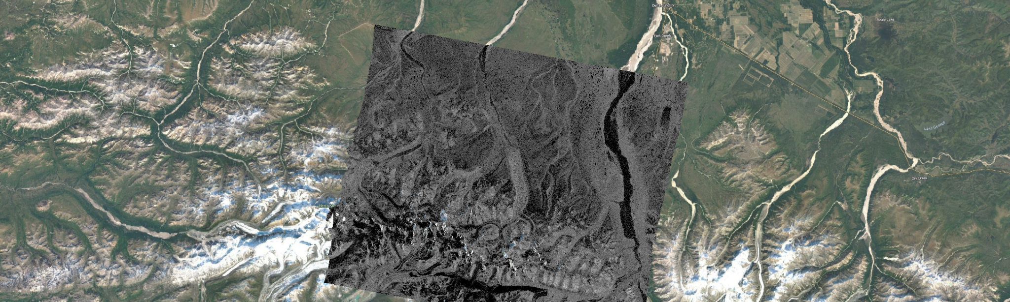
The images below demonstrate the compatibility between PALSAR RTC and Landsat 8. The first image shows the lack of feature alignment in an uncorrected PALSAR L1.5 image combined with a Landsat 8 image. The second image, a fusion of RTC and Landsat 8, shows an excellent match.
| Uncorrected PALSAR and Landsat 8 | PALSAR RTC and Landsat 8 |
|---|---|
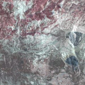 | 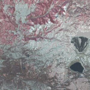 |
| Note the lack of image coherence | Images now align closely |