ALOS PALSAR
ALOS Phased Array type L-band Synthetic Aperture Radar
From 2006 to 2011, PALSAR’s L-band synthetic aperture radar (SAR) yielded detailed, all-weather, day-and-night observation, as well as repeat-pass interferometry. PALSAR data are from multiple observation modes with variable polarization, resolution, swath width, and off-nadir angle.
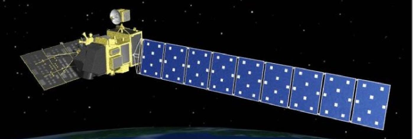
PALSAR was one of three instruments on the Advanced Land Observing Satellite (ALOS), also known as DAICHI, developed to contribute to the fields of mapping, precise regional land-coverage observation, disaster monitoring, and resource surveying. ALOS was a mission of the Japan Aerospace Exploration Agency (JAXA).


Overview
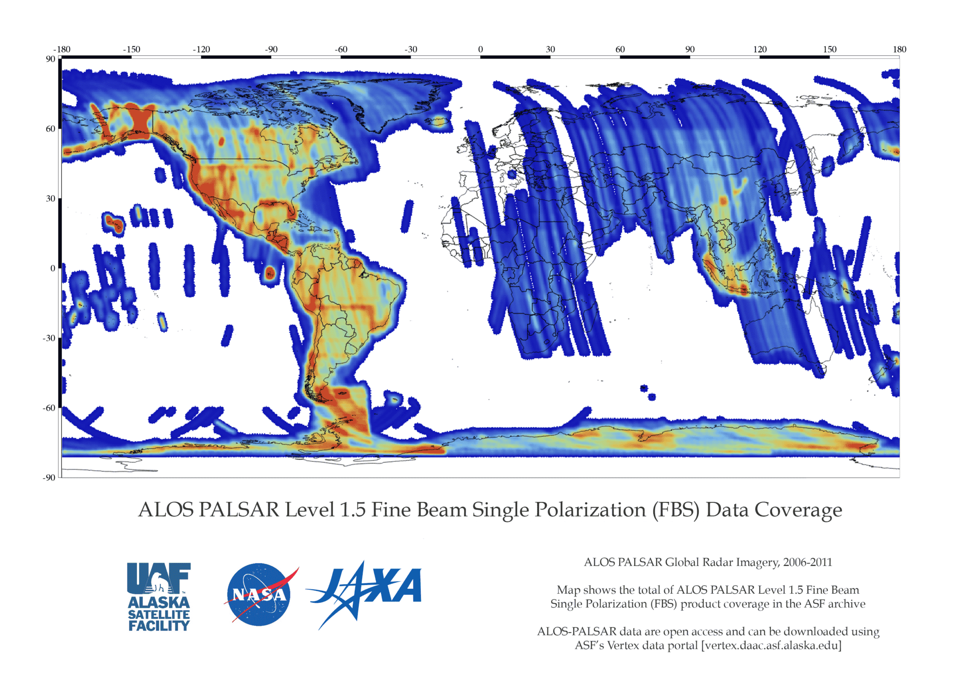
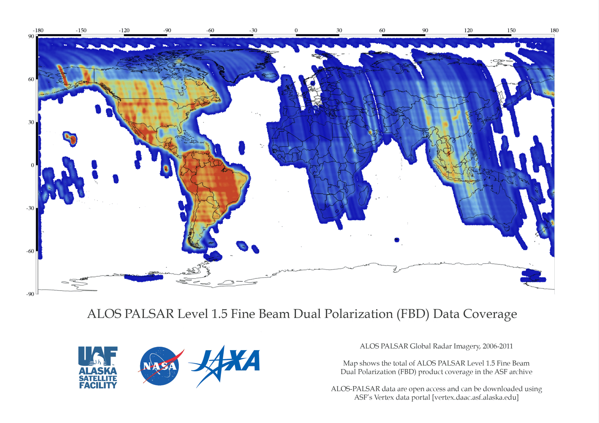
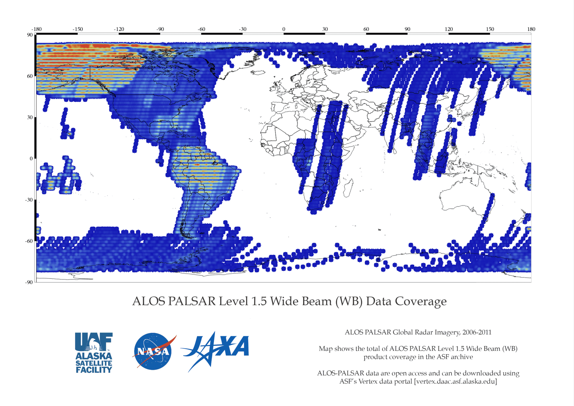
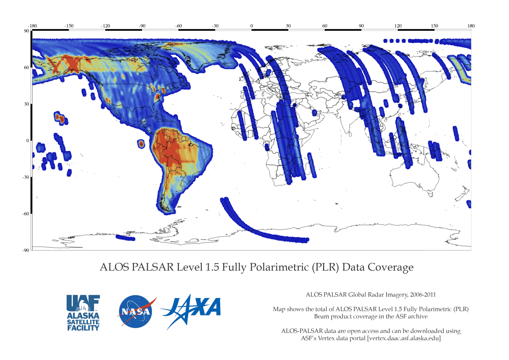
PALSAR has two fine beam modes: single polarization (FBS) and dual polarization (FBD), as well as quad polarization, also known as polarimetric mode (PLR). ScanSAR wide beam (WB1, WB2) operates with a considerable loss of resolution. See table below.
Read More on the JAXA website.
Overview
| Dataset Property | Fine Resolution | Fine Resolution, additional | ScanSAR | Polarimetric |
|---|---|---|---|---|
| Temporal Coverage | 2006-2011 | 2006-2011 | 2006-2011 | 2006-2011 |
| Repeat Cycle | 46 days | 46 days | 46 days | 46 days |
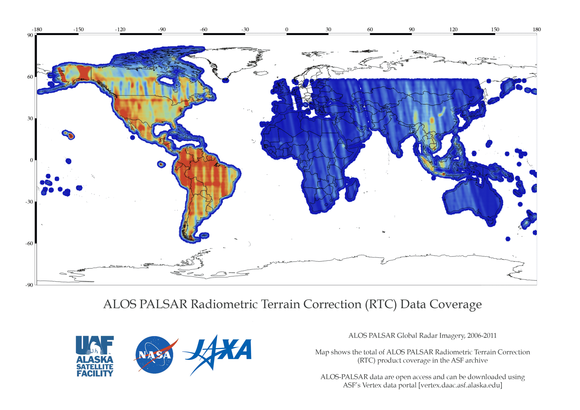
| Spatial Coverage | North, Central, and South America - Complete Outside the Americas - Partial | North, Central, and South America - Complete Outside the Americas - Partial | North, Central, and South America - Complete Outside the Americas - Partial | North, Central, and South America - Complete Outside the Americas - Partial |
| Beam Mode | FBS, DSN | FBD | WB1, WB2 | PLR |
| Center Frequency | L-Band (1.27 GHz) | L-Band (1.27 GHz) | L-Band (1.27 GHz) | L-Band (1.27 GHz) |
| Polarization | HH or VV | HH+HV or VV+VH | HH or VV | HH+HV or VV+VH |
| Spatial Resolution | 10 m | 20 m | 100 m | 30 m |
| Swath Width | 70 km | 70 km | 250-350 km | 30 km |
| Off-Nadir Angle | 34.3° (default) | 34.3° (default) | 27.1° (default) | 21.5° (default) |
| License | See License and Data Citation tab | See License and Data Citation tab | See License and Data Citation tab | See License and Data Citation tab |
| Download info | Data Discovery | Data Discovery | Data Discovery | Data Discovery |
| File format | L1.0,L1.1,L1.5,L2.2, RTC_LOW_RES, RTC_HI_RES,KMZ | L1.0,L1.1,L1.5,L2.2, RTC_LOW_RES, RTC_HI_RES,KMZ | L1.0,L1.1,L1.5,L2.2, RTC_LOW_RES, RTC_HI_RES,KMZ | L1.0,L1.1,L1.5,L2.2, RTC_LOW_RES, RTC_HI_RES,KMZ |
| Provider | Japan Aerospace Exploration Agency (JAXA). | Japan Aerospace Exploration Agency (JAXA). | Japan Aerospace Exploration Agency (JAXA). | Japan Aerospace Exploration Agency (JAXA). |
| Date published: | 2006-2011 | 2006-2011 | 2006-2011 | 2006-2011 |
PALSAR cannot observe the areas beyond 87.8 degrees north latitude and 75.9 degrees south latitude when the off-nadir angle is 41.5 degrees. Read more on the JAXA website.
Coverage Maps
Expand the sections below to view content. Access the full content on a single page by clicking the button.
User Guide/Technical Information
PALSAR Documentation
| Name | Description |
|---|---|
| ALOS Data Users Handbook, 2008ALOS Data Users Handbook, 2008 | Overview of the ALOS Project and related technical information on satellites and land systems |
| ALOS User Guide | Overview, products, product format, operations |
| PALSAR Product Format | Detailed L1.1 and L1.5 product format description |
| Detailed L1.0 product format description |
For information and documentation regarding the ALOS PALSAR radiometric terrain corrected (RTC) products available from ASF, please go to:
Software Tools
| Name | Description |
|---|---|
| MapReady, ASF | Terrain correct, geocode, and apply polarimetric decompositions to multi-pol SAR data |
| Convert to Vector, ASF | Transform point or scene information to formats compatible with Google Earth, GIS, and more |
| Other Software Tools | Access a variety of tools for viewing, analyzing, and processing radar data |
GIS Platforms
| Name | Description |
|---|---|
| QGIS: open source | Windows, Mac, Linux, BSD |
| ArcGIS: commercial software | Windows, Linux |
RTC GeoTIFF products are readily visualized in GIS programs such as ArcGIS or QGIS.
Processors – PALSAR
PALSAR Processor versions used to process data at ASF
| Processing Dates | Processor Version | JAXA Calibration Result as of (MM-DD-YYYY) |
|---|---|---|
| April 18, 2007- April 26, 2007 | 3.00 | 10-23-2006 3-29-2007 |
| April 27, 2007- March 17, 2008 | 4.00 | 3-29-2007 9-28-2007 |
| March 18, 2008 – June 12, 2008 | 4.03 | 9-28-2007 |
| June 13, 2008 – February 3, 2009 | 5.00 | 9-28-2007 |
| February 4, 2008 – ? | 5.04 | 9-28-2007 7-1-2009 |
| September, 2013 | 6.07 | 9-6-2011 |
Processors – Optical
Optical Processor versions used to process data at ASF
| Processing Dates | Processor Version | JAXA Calibration Result as of (MM-DD-YYYY) |
|---|---|---|
| April 18, 2007- April 26, 2007 | 3.00 | 10-23-2006 3-29-2007 |
| April 27, 2007- March 30, 2009 | 4.01 | 3-29-2007 9-28-2007 |
| March 31, 2009 – February 3, 2010 | 5.02 | 9-28-07 7-1-2009 |
| February 4, 2010 – January 18, 2011 | 5.09 | 7-1-2009 |
| January 18, 2011 – Present | 6.03 | 7-1-2009 |
ASF PALSAR Products
ALOS PALSAR Dataset Processing Levels
| Product | Type | Format | Open Access |
|---|---|---|---|
| L1.0 | Unprocessed/raw | n/a | Find Data |
| L1.5 | Georeferenced amplitude image | CEOS | Find Data |
| RTC | Radiometrically and terrain-corrected geocoded GeoTIFF image | GeoTIFF | Find Data |
ALOS PALSAR DOIs
| Dataset | DOI |
|---|---|
| L1.0_PALSAR | 10.5067/J4JVCFDDPEW1 |
| L1.1_PALSAR | 10.5067/PAFUZQHBZF3A |
| L1.5_PALSAR | 10.5067/NXY378J3DFZQ |
License and Data Citation
ALOS PALSAR Standard Product License Agreement
The Alaska Satellite Facility (ASF) grants the End User use of Advanced Land Observing Satellite (ALOS) PALSAR data if the End User accepts and agrees to the following ALOS PALSAR Standard Product End User License Agreement. The End User will be deemed to have accepted and agreed to the terms and conditions if the End User starts using ALOS PALSAR data including but not limited to downloading, installing, manipulation or other action.
Section 1 Definitions
1. “End User” means the person, legal business entity, public entity or any other legal entity who obtains the Product and is considered to have accepted this End User License Agreement. In the case of a public entity, the End User is deemed to be only the part, division, etc. of the public entity located at the address to which the Product is supplied, unless otherwise agreed upon by ASF in writing and in advance.
Standard Product – Level 1 Data (CEOS format) PALSAR Level 1.0, 1.1, 1.5
Derivative Work Product – A processed product using the Standard Product which retains the original pixel structure and can be converted back to the original data or a processed product that does not retain the original pixel structure and cannot be converted back to the original data , with the exception of value-added products
Value Added Product (VAP) – A modified Standard or Derivative Work Product with high-level processing that cannot be converted back to the original product. The high-level processing includes data analysis or combining multiple-satellite data, image processing based on external information, and physical quantity conversion.
2. “Product” means any ALOS satellite data product supplied by ASF. Product is classified as standard product, Derivative-work Product and Value Added Product (VAP). Definition of the three product types is shown below.
3. “JAXA” means the Japan Aerospace Exploration Agency.
4. “METI” means the Japanese Ministry of Economy, Trade, and Industry.
5. “Related Parties” means the parties that have been involved in the creation, production, distribution or delivery of the Product.
Section 2 Permitted Uses
1. The End User shall utilize the Product for peaceful purposes only.
2. The End User may redistribute the Product provided the data source is attributed to JAXA/METI.
Section 3 Prohibited Uses
1. The End User shall not use the Product other than for peaceful purposes.
2. The End User shall not delete, obscure, remove or alter any copyright notice that is contained in or appears on the Product.
Section 4 Intellectual Property Right and Copyright Notice
1. The End User confirms that JAXA and METI own all intellectual property rights, including copyrights, for ALOS PALSAR Standard and Derivative-work products.
2. The End User owns all intellectual property rights, including copyrights, which result from the End User’s act of interpretation, adaptation, authorship or any other work on the Standard Product resulting in the creation of a VAP. All VAP products must be accompanied with the copyright notice.
3. The End User agrees that any embodiment of the Product permitted under this agreement shall contain the following copyright notice. The copyright notice shall be prominently displayed and the [Year] field correctly filled with a numerical value corresponding to the year of raw data acquisition.
Copyright Notice
Standard Product – ©JAXA,METI [Year]
Derivative Work Product – ©JAXA,METI [Year]
Value Added Product – Includes Material ©JAXA,METI [Year]
Section 5 Limited Warranty – Disclaimer
1. Neither ASF nor the Related Parties, if any, warrants that the Product is free of bugs, errors, defects or omissions.
2. The Product is provided as is with no warranty of merchantability or fitness for a particular purpose.
3. ASF and the Related Parties shall have no liability to the End User for any damage suffered by the End User or any third party, as a result of using ALOS PALSAR products. This damage is including but not limited to consequential loss and lost earnings.
Section 6 Modification of this Agreement
ASF reserves the right to modify this agreement if necessary and the modified agreement will govern. In the case of modification ASF will announce on ASF internet site.
Section 7 Governing Law and Jurisdiction
This End User License Agreement shall be governed by the laws of the United States of America.
Citing ALOS PALSAR Data or Imagery
Cite datasets in publications such as journal papers, articles, presentations, posters, and websites. Include the DOI when available (each RTC ALOS PALSAR dataset processed by ASF has an assigned DOI). Please send copies of, or links to, published works citing data, imagery, or tools accessed through ASF to [email protected] with “New Publication” on the subject line.
| Type of Dataset | Format | Example |
|---|---|---|
| ALOS PALSAR L1.0 or L1.5 | Dataset: ©JAXA/METI ALOS PALSAR [dataset name] [year of data acquisition]. Accessed through ASF DAAC, [link to website or insert comma and spell out in print: https://asf.alaska.edu] [day/month/year of data access] | Dataset: © JAXA/METI ALOS PALSAR L1.0 2007. Accessed through ASF DAAC 11 June 2015. |
Crediting ALOS PALSAR Imagery
Include appropriate credit with each image shown in publications such as journal papers, articles, presentations, posters, and websites.
| Type | Format | Example |
|---|---|---|
| Primary or Derived Imagery | ©JAXA/METI [year of data acquisition]. | © JAXA/METI 2007. |
| Value Added Imagery | [creator credit, year created]; Includes Material © JAXA/METI [year of data acquisition]. | ASF DAAC 2014; Includes Material © JAXA/METI 2007. |
ALOS PALSAR Dataset DOIs
| Dataset | DOI |
|---|---|
| L1.0_PALSAR | 10.5067/J4JVCFDDPEW1 |
| L1.1_PALSAR | 10.5067/PAFUZQHBZF3A |
| L1.5_PALSAR | 10.5067/NXY378J3DFZQ |
Discover ALOS PALSAR data
ALOS PALSAR RTC data are open data and may be downloaded using these ASF and NASA Discovery services:
| Data Discovery Tool | Link |
|---|---|
| ASF Vertex Data Search | Vertex |
| Python Search Module | asf_search |
| ASF Search API | ASF Search API |
| NASA Earthdata Search | Earthdata Search |
NOTE: L1.0 and L1.5 products may have originated from older JAXA processor versions.


