

SAR data play a pivotal role in volcano monitoring by detecting ground deformation.
InSAR (Interferometric SAR) techniques create precise deformation maps, highlighting areas of uplift or subsidence, indicators of magma movement.These data aid in tracking volcanic activity, predicting eruptions, and assessing potential hazards. Continuous monitoring enables early warnings and informed decision-making for evacuation and disaster management.
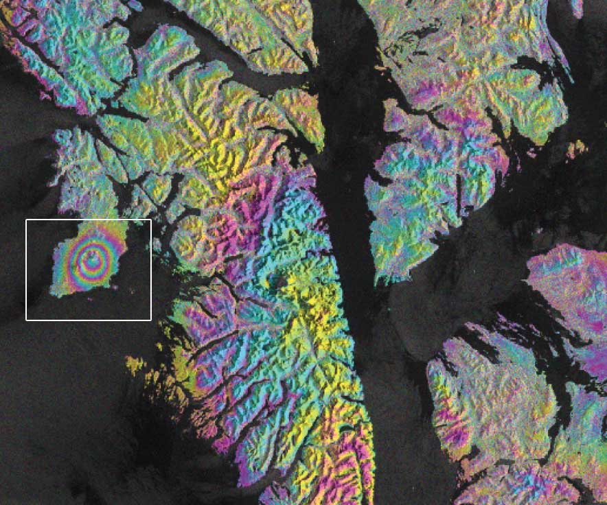
Seismic Swarm
Location: Alaska, USA
Date(s): 2022
Spacecraft/Agency: Sentinel-1 / European Space Agency (ESA).
Credit: Copernicus Sentinel-1 data 2019, processed by ESA; courtesy R. Grapenthin, Y. Cheng, M. Angarita, AVO; photo courtesy Max Kaufman, AVO
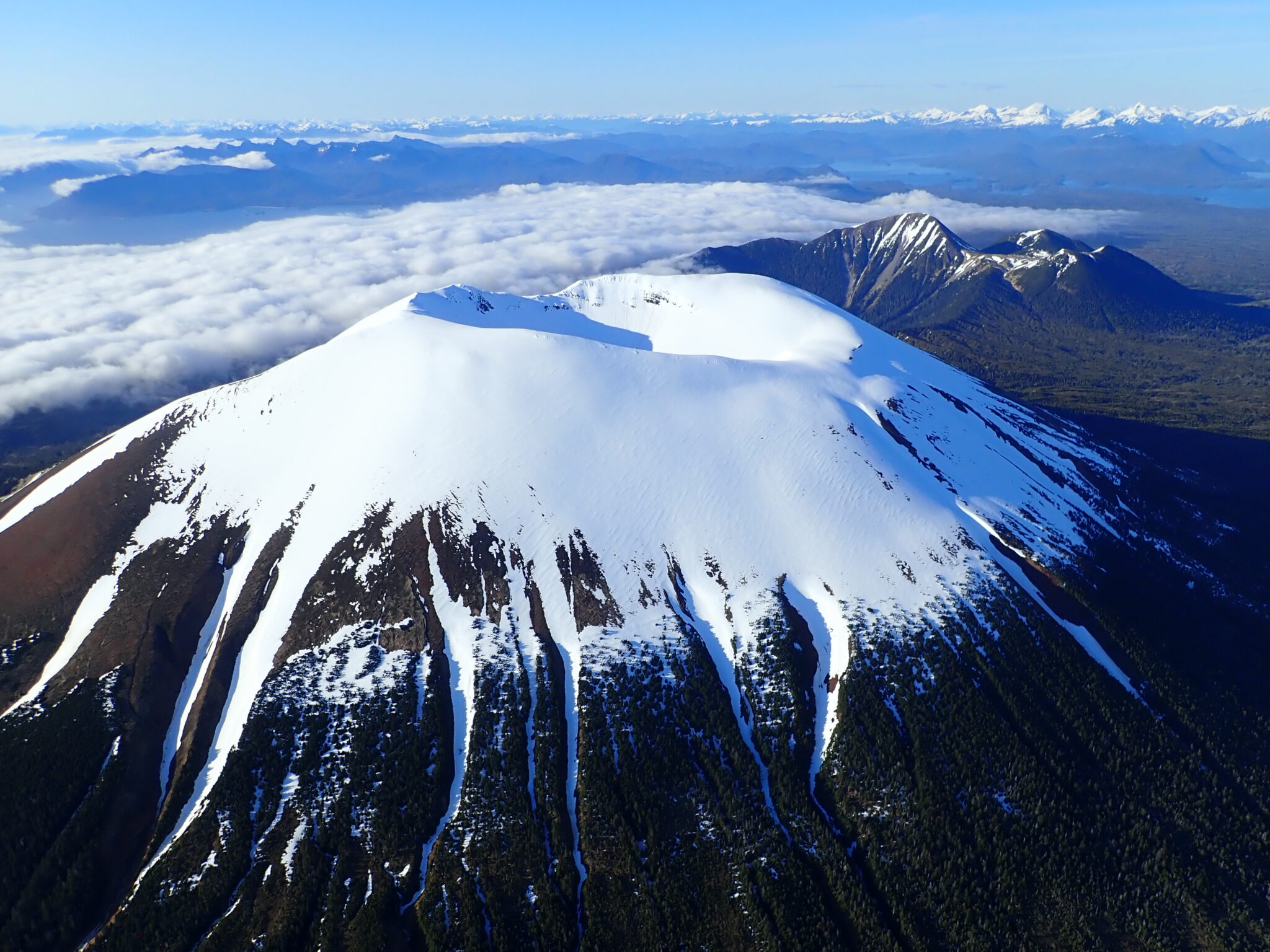
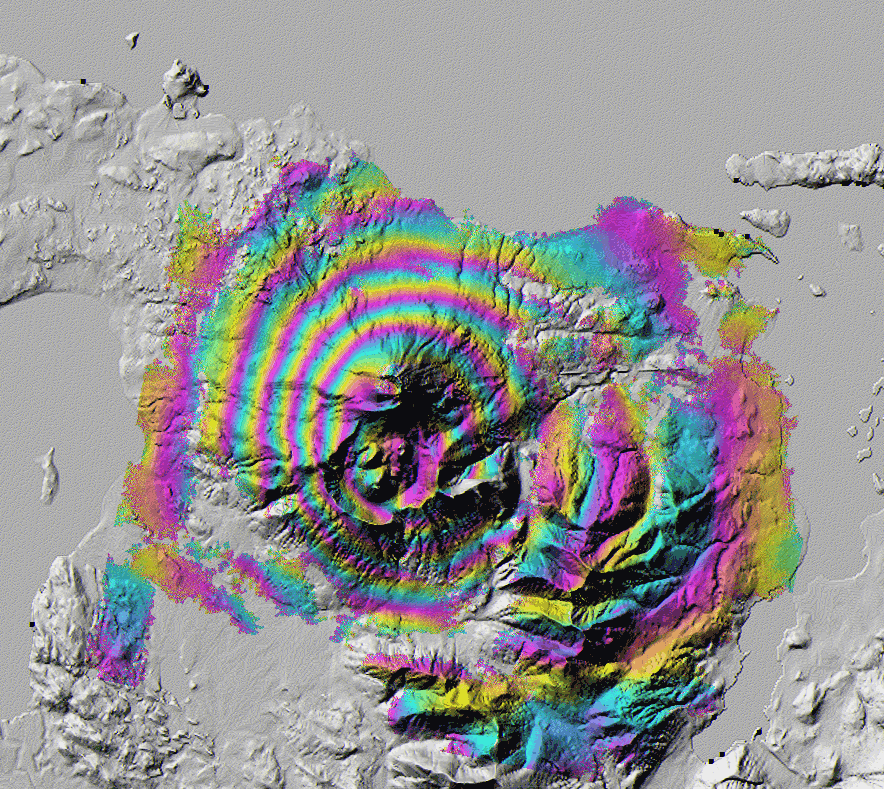
In April 2022 a seismic swarm near Mt. Edgecumbe in southeast Alaska suggested renewed activity at this unmonitored, dormant volcano. Sentinel-1 data obtained from ASF were analyzed to assess volcanic activity by the Alaska Volcano Observatory. Beginning in 2018, surface inflation observed through ASF HyP3-produced interferometry suggests magma movement within the mountain. Analysis of seismicity recorded 25 km away confirms increased activity. The concentric colored circles in this Sentinel-1 interferogram represent this surface distention.
SAR time series sequence
About SAR time series
A SAR time series is an invaluable resource for a wide range of applications. By capturing high-resolution images of the Earth’s surface at different time points, SAR time series enable us to monitor and analyze dynamic processes and changes over time. This technology is particularly useful for tasks like land cover change detection, deformation monitoring (such as subsidence or landslides), and crop growth analysis. SAR’s ability to penetrate cloud cover and provide consistent data regardless of weather conditions makes it a reliable tool for monitoring environmental changes, urban development, infrastructure integrity, and natural disasters. Moreover, SAR time series can assist in disaster management, offering critical insights for early warning systems and post-disaster assessment. Its applications span multiple sectors, including agriculture, forestry, geology, and urban planning, making it an indispensable resource for understanding and addressing various Earth-related challenges.
Aseismic Inflation
Location: Alaska, USA
Date(s): 1996-1998
Spacecraft/Agency: ERS-1/ERS-2 / European Space Agency (ESA).
Credit: © ESA 1996-1998; courtesy Z. Lu et al., Journal of Geophysical Research, 107, B7, 2002.Sentinel-1 / European Space Agency (ESA).
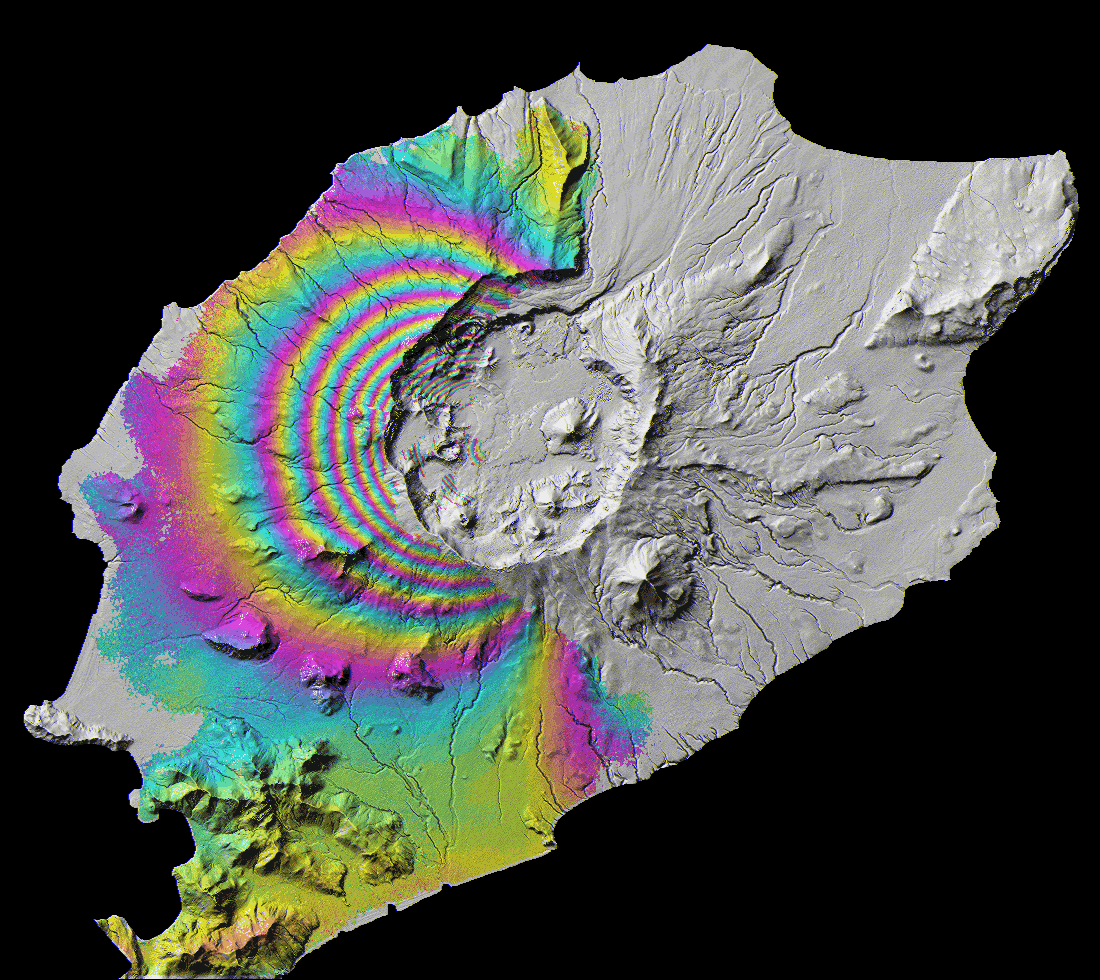
This ERS-1/ERS-2 InSAR image shows about 17 cm (6.7 in.) of volcanic uplift centered on the southwest flank of Mt. Peulik, Alaska, which occurred during an aseismic inflation episode from October 1996 to September 1998. Each fringe corresponds to 2.8 cm (1.1 in.) of vertical change.
Deflation
Location: Alaska, USA
Date: 2008
Spacecraft/Agency: ERS-2 / European Space Agency (ESA).
Credit: © ESA 2008; courtesy Z. Lu.
Okmok Volcano, in the Aleutian Islands, experienced deflation of over 50 cm (19.7 in.) during the fist 13 hours of a 2008 eruption. Each fringe, or color cycle shown here represents approximately 2.8 cm (1.1 in.) of ground movement.

Roughness
Location: Aleutian Islands
Date(s): 2016
Spacecraft/Agency: Sentinel-1 / European Space Agency (ESA).
Credit: Copernicus Sentinel data 2016.
Umnak Island on the left and Unalaska Island on the right are part of the Aleutian Islands archipelago, a chain of volcanic islands that extend from the Alaska Peninsula to the Kamchatka Peninsula in the Russian Far East. In this Sentinel-1 image, the Okmok Volcano caldera is the prominent feature of Umnak Island. Makushin Volcano on the triangular northwest extension of Unalaska Island is less prominent, but is one of the most active volcanoes in the Aleutians. Atmospheric disturbances and currents cause roughness on the ocean surface and produce radar backscatter, also very evident in this image.

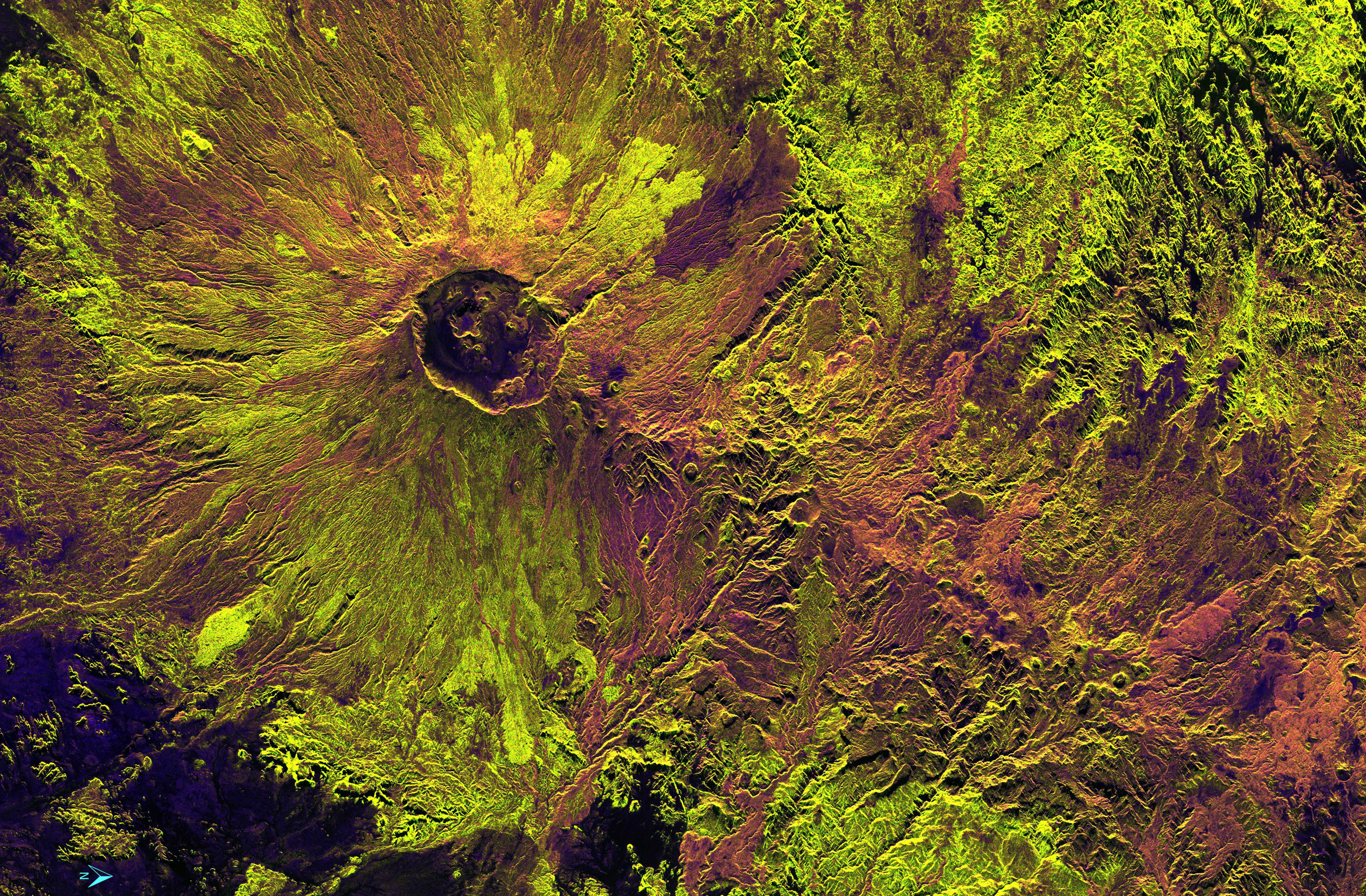
Stratovolcano
Location: Ecuador
Date(s): 2015
Spacecraft/Agency: UAVSAR / NASA.
Credit: NASA JPL 2015.
Cotopaxi is a stratovolcano located 50 km (31 miles) south of Quito, Ecuador. It last erupted in 2015, and with an elevation of 5,897 m (19,347 ft) it is one of the highest active volcanoes in the world. This UAVSAR Pauli decomposition reveals the volcano’s deeply scarred slopes and surrounding valleys, carved out by destructive lahars (debris flows) created by melted ice and snow during eruptions. Eruptions and the resulting lahars pose a constant risk to the nearby city of Latacunga (lower left).


Ancient Lava Flows
Location: Africa
Date(s): 2018
Spacecraft/Agency: Sentinel-1 / European Space Agency (ESA).
Credit: Contains modified Copernicus Sentinel data; courtesy R. Biessel.