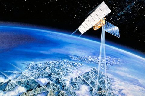
Artist’s view of JERS-1 (image credit: JAXA)
by Kyle C. McDonald and Bruce Chapman
The Japanese Aerospace Exploration Agency (JAXA; formerly known as NASDA) successfully launched the Japanese Earth Resources Satellite (JERS-1, nicknamed FUYO) in late 1992 into a polar sun-synchronous, 44-day, repeat orbit that allowed image coverage of most of the Earth. The JERS-1 instrument package included an L-band, HH-polarized SAR, along with two optical instruments. A primary element of the JERS-1 mission was to acquire imagery of ocean, land, and ice-covered regions with the purpose of demonstrating the technological applications of L-band SAR. Because of some difficulties after launch, the JERS-1 SAR operated at less-than-planned power, yet still was able to complete most of its mission objectives. In spite of its reduced performance, the sensor was well suited for forest studies, and in mid-1993 began a global initiative of systematic image acquisition of tropical forests. Subsequent to the tropical forest data acquisitions, a similar systematic acquisition of boreal forest imagery was undertaken. An important element of this initiative was acquisition of multiple temporally contiguous data sets to allow characterization of the SAR’s ability to discern crucial seasonal processes across broad tropical and boreal landscapes. For some regions, two or more coverages at different seasons (i.e. boreal winter and summer seasons or tropical high-flood and low-flood seasons) were acquired.
The initiative consisted of two projects: the Global Rain Forest Mapping (GRFM) project, and the Global Boreal Forest Mapping (GBFM) project. The initiative was lead by the NASDA Earth Observation Research Center (EORC), with participation by ASF, the Jet Propulsion Laboratory (JPL), the European Commissions Joint Research Centre, and others. The GRFM and GBFM goals were to acquire spatially and temporally contiguous JERS-1 SAR data sets over Earth’s tropical and boreal regions, and to generate continental scale, 100-m resolution image mosaics to be provided for research and educational purposes world wide. Project efforts were focused on several geographical regions, including Boreal North America, Boreal Eurasia, South and Central America, Equatorial Africa, and Southeast Asia, including northern Australia. Each region was mapped at least once between September 1995 and September 1998. In total, more than 25,000 JERS-1 SAR scenes were acquired and assembled into continental-scale products. The SAR data processing of this large undertaking was shared by ASF and NASDA. ASF processed the data from the Americas, while NASDA was responsible for the remaining collections. The related science activities, which are still ongoing, have been conducted by agencies around the world, and thus far have resulted in more than 50 publications. The mosaic products were published on CD ROMs and DVDs and made available to the scientific community at no cost.
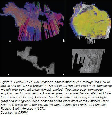
ASF contributed substantially to the GRFM and GBFM through acquisition and processing of substantial amounts of JERS-1 imagery covering the Americas (Figure 1). The entire Amazon Basin, from the Atlantic to the Pacific, was acquired in a single acquisition period during the generally low-flood time of the Amazon River in September-December 1995. This portion of the data set covers an area of about 8 million km2 comprising some 1500 ASF-processed scenes. The same area was covered again in May-August 1996, during a high-flood period of the Amazon River. Imagery of Central America, from Panama to Mexico’s Yucatan Peninsula, was acquired in July-August 1996, complemented by the Pantanal wetland regions in central Brazil in February 1997. Wetland regions in Bolivia, adjacent to the Pantanal were also covered. Boreal North America, extending from Alaska to the Northeastern U.S., was covered during two acquisition campaigns from 1997 and 1998. Summer 1998 and winter 1997/1998 imagery capture these seasons at the continental scale. In addition, more frequent coverage was obtained for the areas
surrounding the ASF station mask. Project team members at JPL assembled these data into continental scale mosaics. SAR image mosaics covering these and the other regions mapped by GRFM/GBFM partners are featured on CD-ROM and DVD media available through ASF. Mosaic products include tiles of 100-m and 2-km resolution backscatter and image texture. As of this writing, the final mosaic products of Northern Eurasia are still under development and have not yet been published for distribution.
Landscape Mapping with GRFM/GBFM Products
Results of the GRFM and GBFM projects have demonstrated the crucial need for consistent, systematic, continental-to-global scale observations of these important biomes. Regional landscape mapping with SAR is important for the information it provides about distribution and characterization of vegetation and wetland ecosystems, including estimation of forest carbon pools, assessment of disturbance and associated changes in biome extent and state, characterization of treeline position, and mapping of river typology. Rapid changes, including those driven by deforestation, fire, permafrost heat balance, flooding, and insect outbreaks can dominate portions of these ecosystems. Landscape features are expected to change as climate and land use patterns change, with significant consequences for global biogeochemical cycles. Forest extent and distribution is changing with human-induced deforestation, with changing frequency and severity of natural fires, and with climate-induced changes in distribution of forest species.
The mapping of wetland regions contributes to studies of intra-annual and inter-annual change. Inundation is an important predictor of methane flux in tropical and boreal wetlands. Inundation may be caused by changes in surface runoff, groundwater, and permafrost heat balance. Thermokarst activity, caused by melting processes in permafrost, has major effects on landforms in both arctic and boreal ecosystems, affecting the distribution of wetlands and tundra ecosystems in arctic regions, the expansion of wetland complexes, and forest succession across the biome. As most of Alaska is underlain by continuous or discontinuous permafrost, changes in thermokarst activity can alter carbon flux significantly.
GRFM and GBFM products have provided for establishment of baseline information, setting the stage for longer-term change detection. JERS-1 mosaic products have been demonstrated to be very useful for wetland delineation, inundation mapping, and discrimination between woody and non-woody vegetation. The availability of subsequent data sets, such as those expected from the ALOS PALSAR, will allow for comparisons of derived products across several years, providing additional information about short-term landscape change.
Landscape Mapping: Tropical Rain Forest Regions
Tropical rain forests straddle the Earth’s equatorial regions, covering an area of roughly 10-million-square kilometers. These regions serve as a major pumping mechanism for the cycling of water, energy and carbon. The health of these forests is of global importance, particularly since continued development and deforestation from logging and agriculture threaten these regions. Seasonally inundated forests, woodlands, and grasslands are widespread in tropical rainforest basins. The duration and extent of wetland inundation are critical for the ecological, biogeochemical, and hydrological functioning of these ecosystems, as they impact carbon storage, trace gas fluxes, and the prospect of sustainable land use in these areas. Tropical wetland ecosystems are experiencing increasing threat, including clearance and conversion, rising sea levels, extreme climate events, and sediment deposition. These degrade erosion control, fisheries conservation, and wildlife habitat.

The capabilities of JERS-1 SAR for tropical wetlands mapping were clearly demonstrated by several GRFM studies. Time series imagery has been used to map inundation periodicity in major portions of the Amazon basin and wetland extent for the lowland Amazon. Results were employed to estimate methane emissions from wetland regions as well as to estimate carbon dioxide release from Amazonian rivers.
Landscape Mapping: Tropical Rain Forest Regions
The boreal forest consists of a circumpolar band of predominantly evergreen coniferous trees interspersed with a smaller component of hardy deciduous species. Conifers include spruce, pine and fir, while deciduous species include larch, birch, aspen, and poplar. Seasons cycle between dark cold winters and brief warm summers. The presence of permafrost leads to shallow rooting depths and pooling of surface water. The timing of spring thaw and length of the growing season govern annual cycles of forest growth, fire and other successional processes. Fire is an integral component of the boreal landscape, unlocking nutrients from vegetation and cold soils, releasing them for new plant growth. Animal and insect life cycles are also controlled by the seasons. Variations in seasonal freeze/thaw processes can be spatially and temporally complex. Landscape complexity can affect the timing of seasonal freeze/thaw transitions as a result of local-scale variations in land cover, snow cover, or topography, including elevation, and slope aspect. JERS-1 SAR imagery collected under the GBFM project has been used to characterize this heterogeneity in focused study regions of the North American high latitudes. Observed variations in freeze/thaw transition have been delineated by landcover, slope aspect, and elevation. These considerations underscore the importance of a combined temporal and spatial accuracy particularly for complex landscapes.
References
Podest, Erika V., 2005. Monitoring Boreal Landscape Freeze/Thaw Transitions with Spaceborne Microwave Remote Sensing, Ph.D. Dissertation, University of Dundee, Scotland, UK.
Siqueira, Paul, Chapman, Bruce, and McGarragh, Greg. 2003. The coregistration, calibration, and interpretation of multiseason JERS-1 SAR data over South America. Remote Sensing of the Environment, 87(15 November 2003), pp 389-403.
This work was carried out at the Jet Propulsion Laboratory, California Institute of Technology, under contract with the National Aeronautics and Space Administration.


