

“A rare characteristic of the SMAP Project is its emphasis on serving both basic Earth System science as well as applications in operational and practice-oriented communities.”
Contents of Full Handbook
1. Introduction and Background
2. Mission Overview
3. Instrument Design and L1 Data Products
4. Soil Moisture Data Products
5. Value-Added L4_SM Soil Moisture Product
6. Carbon Cycle Data Products
7. Science Data Calibration and Validation
8. NASA SMAP Applications Program
9. SMAP Project Bibliography
SMAP Handbook Excerpts on ASF’s Roles
The Alaska Satellite Facility (ASF) is one of four ground stations that support the SMAP mission and one of two NASA DAACs that distribute SMAP data. The SMAP baseline science data products will be generated within the project’s Science Data System and made available publicly through the two NASA-designated Earth-science data centers. The ASF Synthetic Aperture Radar (SAR) Distributed Active Archive Center (DAAC) will provide Level 1 radar products, and the National Snow and Ice Data Center (NSIDC) DAAC will provide all other products. The excerpts below from the SMAP Handbook focus on ASF’s roles. Read more about ASF
Ground Data System (GDS)
The primary path for commanding the SMAP observatory and returning science and engineering data is through three northern-hemisphere tracking stations and one southern-hemisphere station in Antarctica. Data return at the northern-hemisphere stations is via 11.3-m antennas located at Wallops, Virginia (WGS), Fairbanks, Alaska (ASF), and Svalbard Island, Norway (SGS). Data return at the southern-hemisphere station is via the 10-m antenna at McMurdo Station, Antarctica (MGS). The table below gives characteristics of the four stations and average contact statistics from the science orbit. Because SMAP is in a near-polar orbit, the higher latitude stations have more frequent contact opportunities.
| Ground Station | Antenna | Latitude | Average # of Contacts per day* | Average Coverage Minutes/day* |
|---|---|---|---|---|
| Svalbard (SGS) Norway | 11.3 m | 78.2ºN | 10.3 | 88.3 |
| Fairbanks (ASF) Alaska | 11.3 m | 64.9ºN | 6.8 | 53.7 |
| Wallops (WGS) Virginia | 11.3 m | 37.9ºN | 3.3 | 25.8 |
| McMurdo (MGS) Antarctica | 10.0 m | 77.8ºS | 10.4 | 90.7 |
ASF DAAC Support of NASA Missions
The ASF DAAC provides support for NASA and NASA-partner missions assigned to it by the Earth Science Data and Information System (ESDIS) Project. The ASF DAAC has extensive experience managing diverse airborne and spaceborne mission data, working with various file formats, and assisting user communities to further the use of SAR data.
These efforts are facilitated, in part, by ASF Scientists and Data Managers, who interact with mission teams, provide subject matter expertise, inform data and metadata formats, evaluate data structure and quality, and address data support needs. A key project component at ASF is the core product team, which provides integration of new datasets into the ASF data system and ensures efficient coordination and support of each mission. The team members have mission-specific expertise and consist of the following personnel:
- The Project Manager is the team leader who oversees mission activities at ASF and coordinates with external groups.
- The Product Owner is a primary product stakeholder and oversees ingest, archive, documentation, and distribution of data products as well as managing interactions with mission and ASF scientists and other stakeholders.
- The User Services Representative ([email protected]) supports data users with products and software tools and communicates user feedback or suggestions for improvement to the Project Manager and Product Owner.
- Software Engineers design, develop, and maintain software for the acquisition, processing, archiving, and distribution of satellite and aerial remote sensing data.
- Software Quality Assurance Technicians provide software and web-based-application testing prior to delivery to the production data system to ensure integrity, quality, and overall proper functionality through testing methods to uncover program defects, which in turn are reported to software engineers.
- The Technical Science Writer composes and edits a variety of ASF materials, from newsletter articles to technical documentation.
The core product team’s responsibilities for data management include:
- Ingesting, cataloging, archiving, and distributing data
- Providing guidance on file formats and integration of new file formats into the ASF data system
- Describing data products and producing user manuals and guide documents
- Creating metadata and exporting it to CMR and GCMD (Global Change Master Directory)
- Ensuring accurate metrics are reported to EMS (ESDIS Metrics System)
- Designing, developing, and deploying specialized data portals that allow online access to data products and information
- Creating software tools for data interpretation and analysis
- Assisting users with the selection and usage of data
ASF also supports NASA and partner missions through the operation of a ground station with two 11-m antennas, providing complete services, including data downlinking, commanding, and range/Doppler tracking. ASF is part of the NASA Near Earth Network (NEN) supporting a variety of low-Earth-orbit spacecraft.
ASF DAAC Data Systems
The ASF DAAC operates a custom data system designed, implemented, and supported by DAAC personnel. During its evolution, the ASF data system has moved from using primarily custom software on capital equipment to commodity hardware and commercial off-the-shelf (COTS) software and hardware solutions. This has greatly lowered development and maintenance costs for the data system, while simultaneously providing a higher level of performance. The ASF DAAC data system provides the following capabilities:
Data Ingest
- Automated data ingest occurs from the ASF ground station as well as external data providers in a variety of media and formats.
- Ingested data are pre-processed when necessary, providing browse or derivative products.
Data Archive
- The central ASF data system archive is provided by a Data Direct Networks gridscaler storage system.
- This system provides direct access to over 1 PB of processed data as well as the capability for automated backups to an offsite location.
- Raw data are held in a robotic silo for access by the processing system. ASF maintains a backup in an external location in case of silo failure.
Data Distribution
- ASF provides direct http access to DAAC data products and utilizes NASA’s User Registration System (URS) for user authentication.
- NASA data are provided to public users with no restrictions. Partner data are provided to NASA-approved users through URS for authentication and ASF’s internal database for access control.
- The data system provides web-based access to the archive through Vertex. Vertex supports the data pool with direct download of processed data.
- Through custom portals and applications, the DAAC provides additional services such as mosaic subsetting, mosaicking, and time-series analysis.
Data Support
- ASF DAAC exports relevant metadata to NASA’s ECHO system.
- ASF DAAC exports ingest, archive, and download metrics to NASA’s EMS system.
- ASF DAAC assists users with data discovery and usage, maintains product documentation and use guides, and supports feedback between the ASF user community and the core product teams.
SMAP at ASF DAAC
ASF provides a variety of services, software tools, and user support to address the needs of the SMAP user community. The ASF core project team will leverage on-going collaborations with the SMAP Project to identify and prioritize SMAP user community needs, which in turn will inform development and implementation of data support and value-adding services for the mission. The SMAP website at ASF will serve as an interactive data portal, providing users with relevant documentation, custom tools and services, and ancillary data and resources.
Post-Launch SMAP Data
ASF will ingest, distribute, archive, and support postlaunch Level 1 radar products for the SMAP mission. ASF will receive the Level 1 radar products from the SMAP Science Data System at the Jet Propulsion Laboratory (JPL) in Pasadena, California.
Non-SMAP Data of Interest to SMAP
ASF will cross-link from the SMAP website to data collections that complement SMAP data and are of interest to the user community. Some of these collections are distributed by ASF, including the following:
- Airborne Microwave Observatory of Subcanopy and Subsurface (AirMOSS) data products
- Jet Propulsion Laboratory Uninhabited Aerial Vehicle SAR (UAVSAR) data products
- Making Earth System Data Records for Use in Research Environments Inundated Wetlands (MEaSUREs) data products
- Advanced Land Observing Satellite-Phased Array L-band SAR (ALOS PALSAR)
- Japanese Earth Resources Satellite-1 (JERS-1) image data and mosaics
Acronyms
| Acronym | Definition |
|---|---|
| ASF | Alaska Satellite Facility |
| ATBDs | Algorithm Theoretical Basis Documents |
| Cal/Val | Calibration and Validation |
| DAAC | Distributed Active Archive Center |
| HDF5 | Hierarchical Data Format |
| JPL | Jet Propulsion Laboratory |
| NASA | National Aeronautics and Space Administration |
| NSIDC | National Snow and Ice Data Center |
| ROP | Routine Observations Phase |
| SMAP | Soil Moisture Active Passive |
| SAR | Synthetic Aperture Radar |
| SDS | Science Data System |
| SOP | Science Operations Phase |
| UTC | Coordinated Universal Time |
SMAP’s spaceborne Earth-observation mission will enable global mapping of soil-moisture and freeze-thaw state with unprecedented accuracy, resolution, and coverage. SMAP science objectives are to acquire space-based, hydrosphere-state measurements over a three-year period to:
- Understand processes that link the terrestrial water, energy, and carbon cycles
- Estimate global water and energy fluxes at the land surface
- Quantify net carbon flux in boreal landscapes
- Enhance weather-forecast and climate-forecast skills
- Develop improved flood-prediction and drought-monitoring capabilities
Water and Energy Cycles, Weather, and Climate
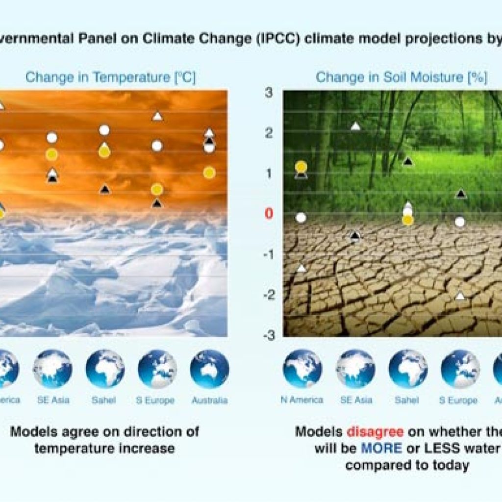
Recent model simulations of the effects of greenhouse gases on climate show that current models agree quite well in predicting temperature change but disagree significantly in predicting surface-moisture change and water-resource availability. Accurate soil-moisture information, such as data from SMAP, will improve the performance and enhance the predictive ability of numerical weather-prediction models and seasonal climate models. Soil moisture is a key control on evaporation and transpiration at the land-atmosphere boundary. Because vaporizing water requires large amounts of energy, soil-moisture control also has a significant impact on the surface energy flux. Soil-moisture variations affect the evolution of weather and climate, particularly over continental regions.
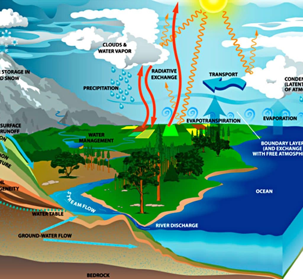
Earth’s water cycle involves the transfer and storage of water in the atmosphere, on the planet’s surface, underground, and by life in its many forms.
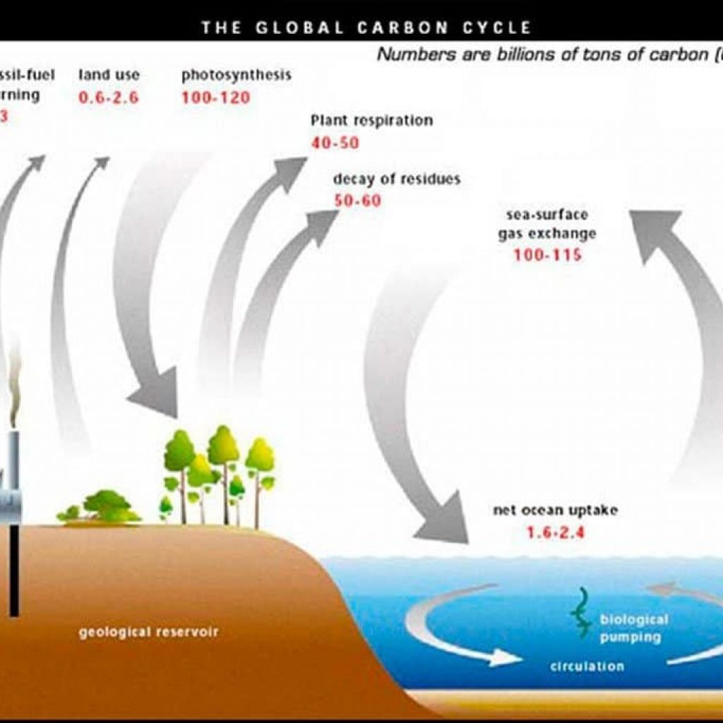
Carbon Cycle and Ecosystems
Soil moisture and its freeze-thaw state are also key determinants of the global carbon cycle. Carbon uptake and release in boreal landscapes is one of the major sources of uncertainty in assessing the carbon budget of the Earth system (the so-called missing carbon sink). The SMAP mission will quantify the nature, extent, timing, and duration of landscape seasonal freeze-thaw state transitions that are key to the estimation of terrestrial carbon sources and sinks. SMAP freeze-thaw state measurements will also contribute to understanding how ecosystems respond to and affect global environmental change, improving regional mapping and prediction of boreal-Arctic ecosystem processes.
SMAP Goals
The SMAP Project is designed to collect measurements of surface soil moisture and freeze-thaw state, together termed the hydrosphere state. Soil moisture is defined in terms of volume of water per unit volume of soil. Freeze-thaw state is defined as the phase of the water contained within the landscape including soil and vegetation. To meet the goals of science and applications users, SMAP must:
- Resolve hydrometeorological water and energy flux processes and extend weather and flood forecast skill, spatial resolution of 10 km and temporal resolution of 3 days are required.
- Resolve hydroclimatological water and energy flux processes and extend climate and drought forecast capability, spatial resolution of 40 km and temporal resolution of 3 days are required.
- Quantify net carbon flux in boreal landscapes, spatial resolution of 3 km and temporal resolution of 2 days are required. In addition, the SMAP mission will validate a space-based measurement approach that could be used for future systematic hydrosphere state monitoring missions.
SMAP News
NASA Soil Moisture Radar Ends Operations; Mission Science Continues
NASA Focused on Sentinel as Replacement for SMAP Radar
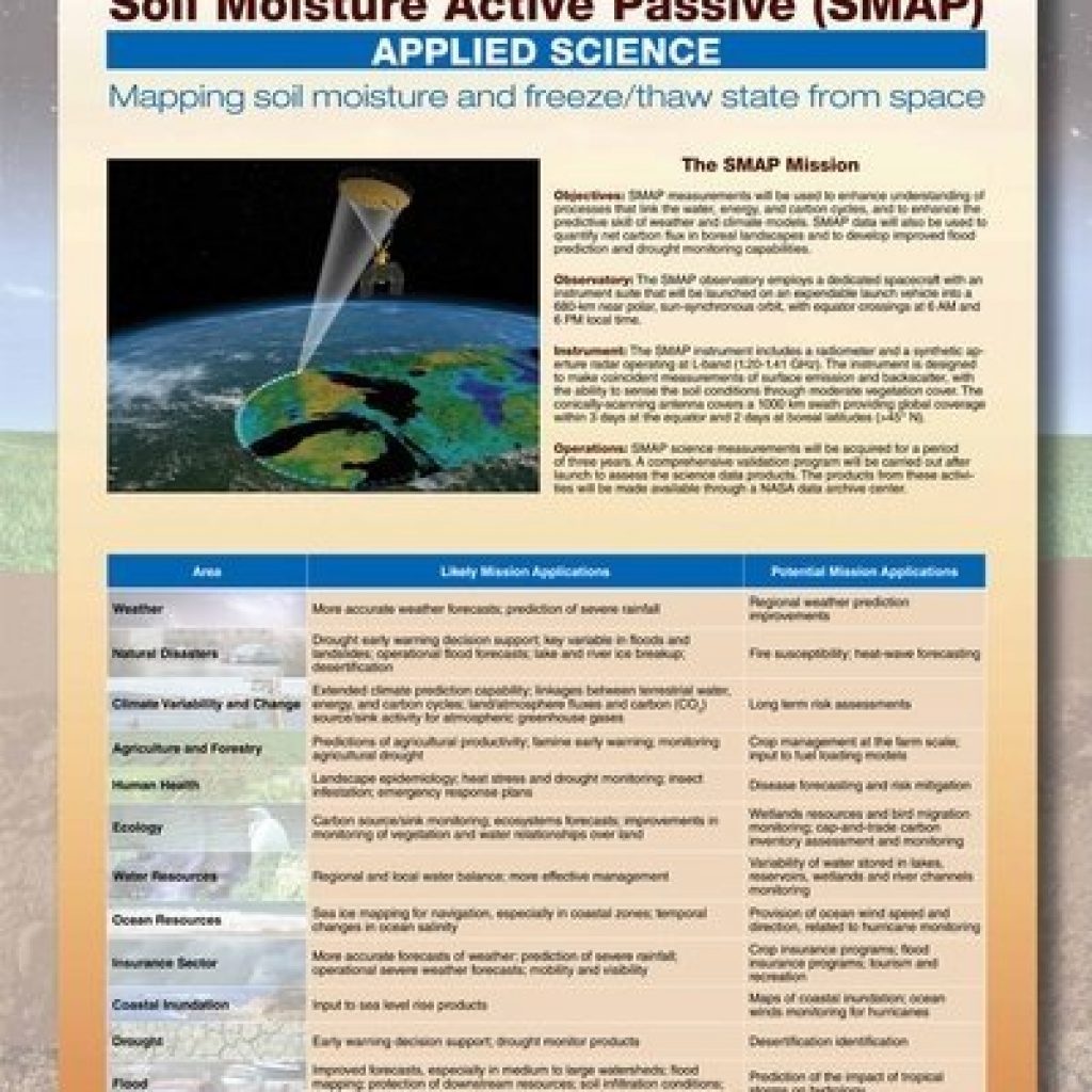
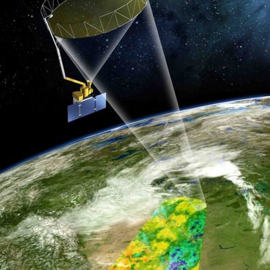
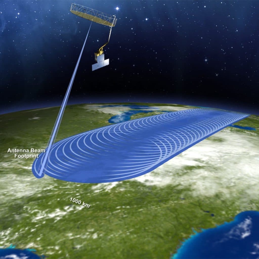

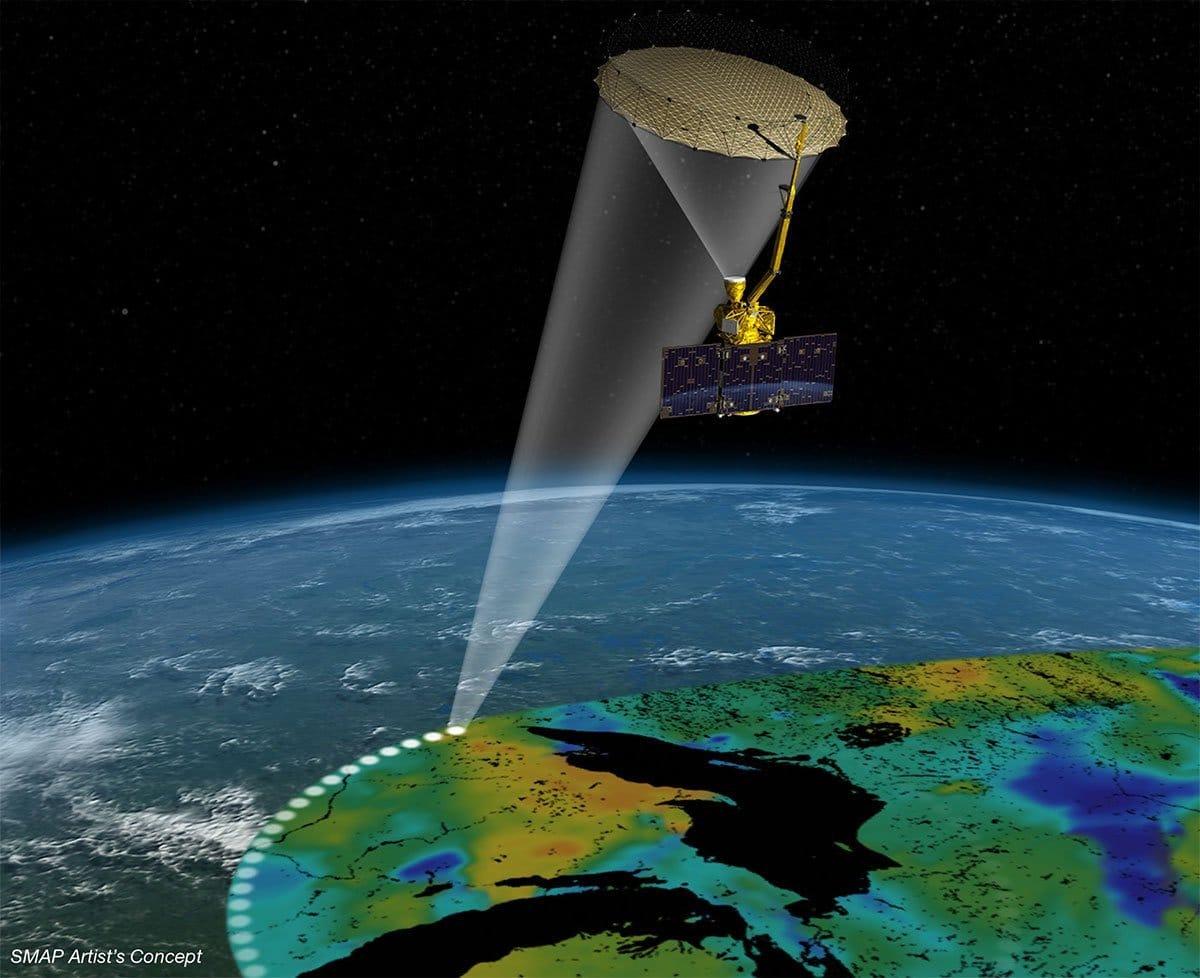
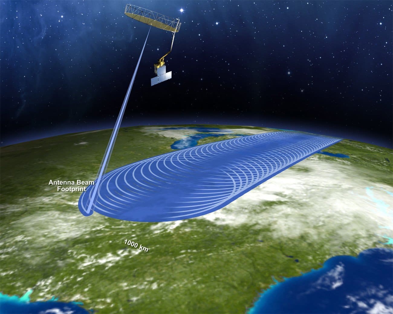
Soil Moisture Passive Active (SMAP) is a remote-sensing observatory with two instruments — a synthetic aperture radar (SAR) and a radiometer — that map soil moisture and determine the freeze or thaw state of the area being mapped. Both instruments help map soil-moisture content, and unique properties of SAR enable the freeze-thaw mapping. Externally, the instruments share a common, 20-foot mesh antenna and a feed assembly. Inside the spacecraft, their electronics differ. When combined, the SMAP radar and radiometer deliver high-accuracy, high-resolution global maps of the Earth’s soil moisture and freeze-thaw state.
The radar actively sends pulses of radio waves down to a spot on Earth and measures the echo that returns microseconds later. The strength and “shape” of the echoes can be interpreted to indicate the moisture level of the soil, even through moderate levels of vegetation. The radiometer passively detects radio waves emitted by the ground from the same small area. The strength of the emission indicates temperatures.
News: NASA Soil Moisture Radar Ends Operations; Mission Science Continues
News: NASA Focused on Sentinel as Replacement for SMAP Radar
 |  | 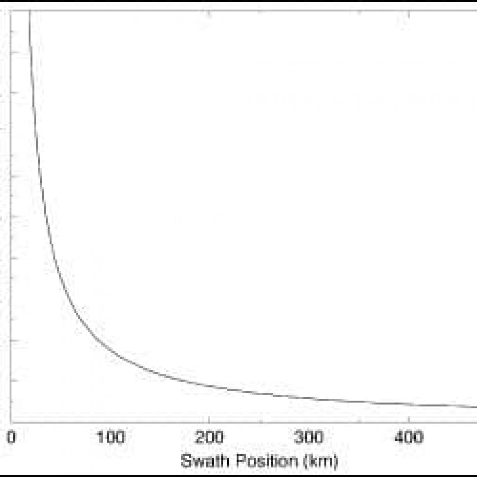 |
|---|---|---|
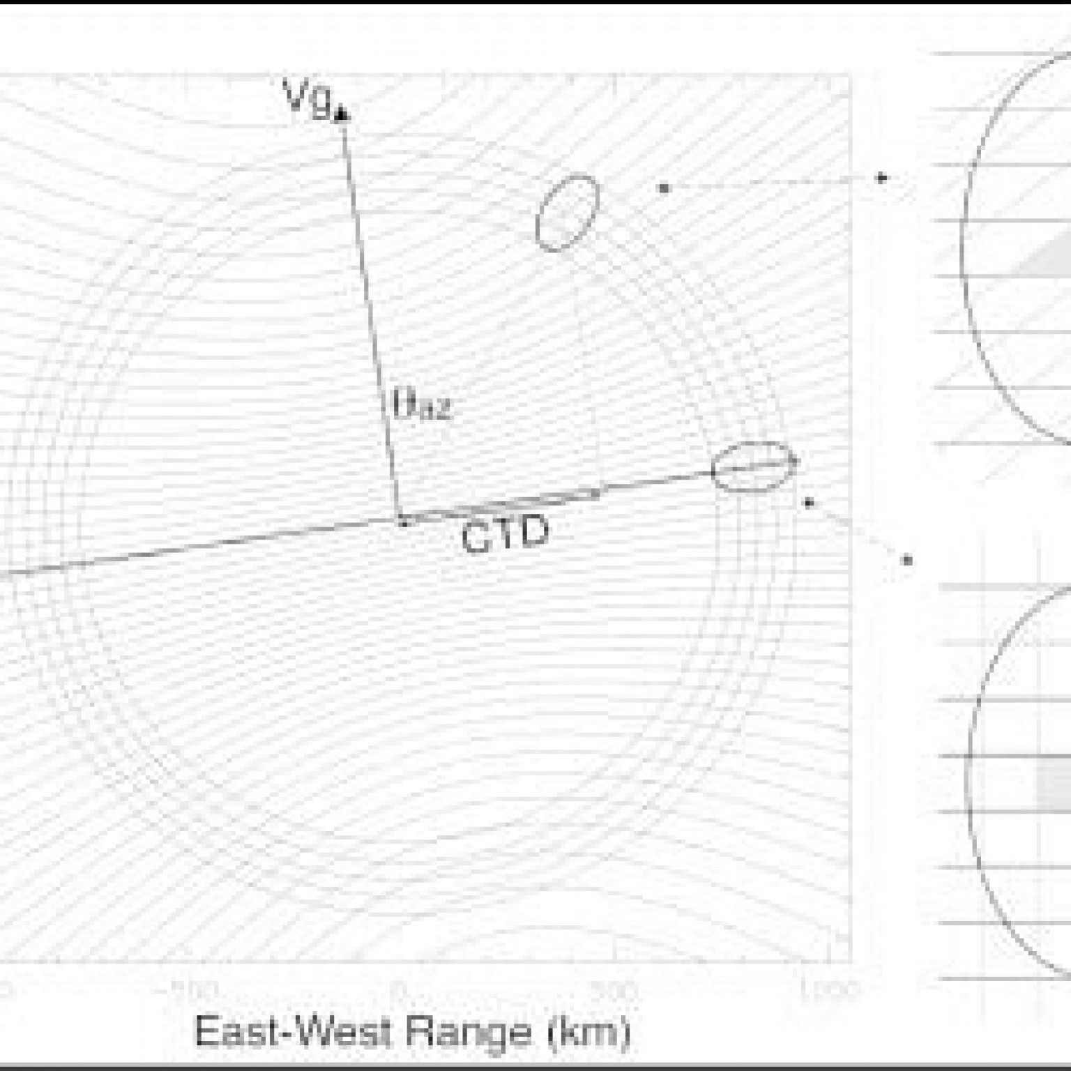
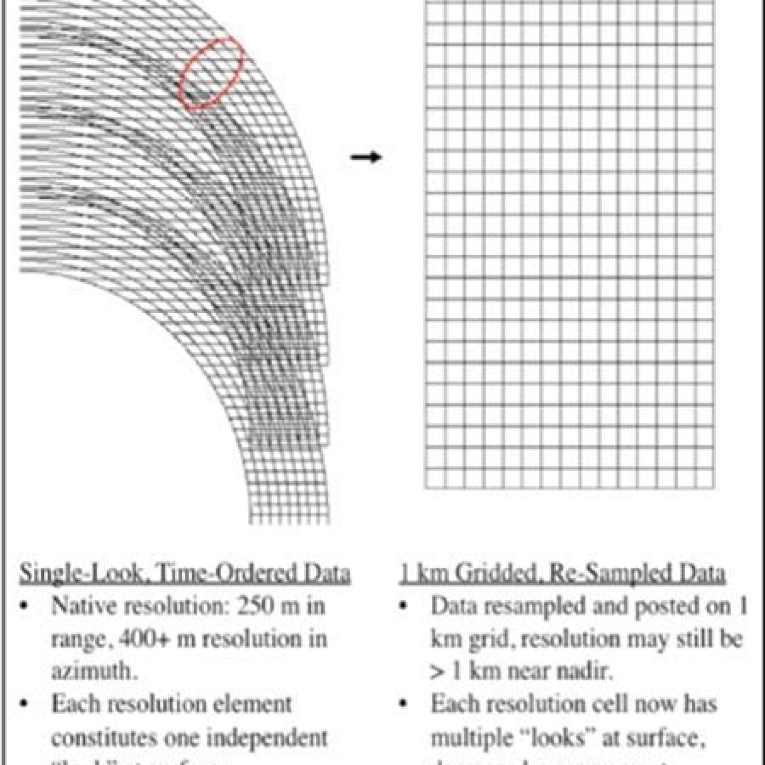
| This panel illustrates the radar-measurement geometry showing the range and Doppler contours. The real aperture radar footprint ellipse is shown at two representative azimuth-scan angles. The radar 1-MHz bandwidth yields a ground-range resolution of ~250 m. The doppler diversity is maximum at a scan angle perpendicular to the satellite velocity (swath edge), leading to an azimuth single-look resolution of ~450 m. The single-look resolution degrades as the scan angles approach the satellite velocity vector. Image Credit: NASA/JPL. | This schematic, which is not drawn to scale, illustrates how the single-look data samples from successive fore-look scans are oriented and overlap relative to the 1-km gred. Image Credit: NASA/JPL. | This panel illustrates the variation as a function of swath position (distance from center track). Image Credit: NASA/JPL. |