






Synthetic Aperture Radar (SAR) and Interferometric Synthetic Aperture Radar (InSAR) are advanced remote sensing technologies.
SAR and InSAR have revolutionized our ability to observe and analyze the Earth’s surface with unprecedented precision and detail. These technologies utilize radar signals to create high-resolution images and generate topographic information, offering researchers, scientists, and various industries invaluable insights into a wide range of natural and anthropogenic phenomena.
How SAR works
The Synthetic Aperture is the distance a satellite or aircraft travels over a target while that target is illuminated by the radar. This allows the “antenna” to be miles larger than any physical antenna and results in much higher image resolutions.

| Band | L-Band | S-Band | C-Band | X-Band | Ka-Band |
|---|---|---|---|---|---|
Description | (1-2 GHz) (30-15 cm)
Lower resolution SAR than S, C, or X bands, but more coherent in heavily vegetated regions. Used for geophysical monitoring,
biomass and vegetation mapping, and high penetration and interferometric SAR. | (2-4 GHz) (15-7.5 cm)
Increasingly used for SAR-based Earth observation and agriculture monitoring and by expanding C-band applications to higher vegetation density. | (4-8 GHz) (7.5-3.75 cm)
A popular SAR workhorse for global mapping, change
detection, and monitoring areas with low to moderate
penetration, as well as ice, and ocean navigation. Also
used for 5G networks, satellite TV, broadcasting, and two-way radio. | (8-12 GHz) (3.75-2.4 cm)
High resolution SAR with little vegetation penetration. Particularly useful for urban, ice, and snow monitoring. Also used for imaging
radar and satellite communications. | (27 to 40 GHz) (11.3mm – 5mm)
The Ka-band represents a significant technology change for the industry in regard to communications with satellites. |

Microwave echoes
SAR works by transmitting microwave pulses from a satellite or airplane toward the Earth’s surface and measuring the signals that bounce back. Unlike optical sensors, SAR is not reliant on sunlight to illuminate the Earth’s surface and can penetrate through clouds, which means it can operate regardless of weather conditions or time of day, or season. This makes it a powerful tool for continuous monitoring in a variety of environments, from urban landscapes to dense forests, during rainy seasons and long polar nights.
What is InSAR
InSAR (Interferometric Synthetic Aperture Radar) takes SAR technology a step further by enabling the creation of highly accurate deformation maps. It achieves this by analyzing the phase differences between two or more SAR images taken at different times. This technique allows researchers to detect even subtle ground movements, such as subsidence, uplift, or tectonic plate shifts, with millimeter-level precision.
InSAR can also provide digital elevation models, using SAR images taken from slightly different positions. InSAR has applications in geology, environmental science, and civil engineering, providing critical information for understanding natural hazards like earthquakes, landslides, and volcanic activity.
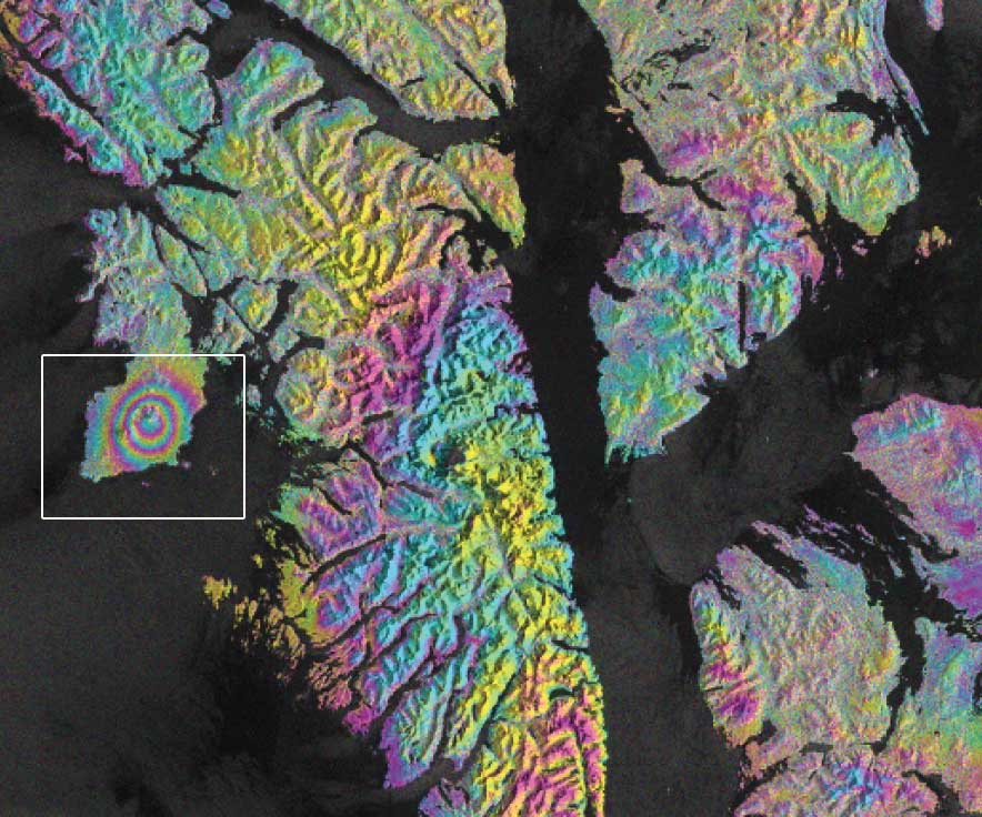
Mt. Edgecumbe, Credit: Copernicus Sentinel-1 data 2019, processed by ESA; courtesy R. Grapenthin, Y. Cheng, M. Angarita, AVO; photo courtesy Max Kaufman, AVO
RGB image decompositon
The colors in a SAR image are chosen by the researcher so that the image best reveals the features of interest. A major reason we do this is because human visual processing is extremely fast and powerful. By creating false color images, it allows those of us with the privilege of sight to leverage that incredibly useful built-in piece of natural equipment to quickly understand what is happening in a scene.

This Advanced Land Observation Satellite (ALOS) AVNIR-2 near-infrared image shows the stark contrast between the productive agricultural region of the Imperial Valley (red-colored fields) and the Sonoran Desert of southern California and northern Mexico.
Red channel

A Double bounce can be caused by buildings, trees, trucks, ships; where a vertical surface intersects a horizontal surface. These signals are common in urban areas. Commonly shown using the RED channel
Green channel

Volume scatter can be caused by a forest canopy or other vegetation; multiple flat surfaces at different angles that scatter with high cross-polarity signal returns. Glacial ice also causes a large volume to surface scattering ratio. Commonly shown using the GREEN channel
Blue channel

Surface bounce can be caused by calm water, roads; horizontal surfaces that reflect the signal away from its source. In this use, blue can also represent very dry, porous surfaces, such as desert landscapes, that absorb the signal. Commonly shown using the BLUE channel
Subdued colors

Surface scattering can be caused by a rough surface or vegetation that bounces much of the signal away from the satellite, resulting in much weaker returns. This can be shown through weaker, more subdued colors in an image.
SAR time series sequence
About SAR time series
A SAR time series is an invaluable resource for a wide range of applications. By capturing high-resolution images of the Earth’s surface at different time points, SAR time series enable us to monitor and analyze dynamic processes and changes over time. This technology is particularly useful for tasks like land cover change detection, deformation monitoring (such as subsidence or landslides), and crop growth analysis. SAR’s ability to penetrate cloud cover and provide consistent data regardless of weather conditions makes it a reliable tool for monitoring environmental changes, urban development, infrastructure integrity, and natural disasters. Moreover, SAR time series can assist in disaster management, offering critical insights for early warning systems and post-disaster assessment. Its applications span multiple sectors, including agriculture, forestry, geology, and urban planning, making it an indispensable resource for understanding and addressing various Earth-related challenges.
Evolving technologies
The use of spaceborne and airborne SAR and InSAR (Interferometric Synthetic Aperture Radar) technologies has opened new frontiers in Earth observation and scientific research. Their ability to capture detailed, near-real-time data over large areas at any time of day or night and through clouds and fog, coupled with their applications across various disciplines, offers a powerful means to study and address complex challenges facing our planet. As these technologies continue to evolve, their impact on advancing our understanding of natural processes and human activities is likely to grow, paving the way for more informed and effective strategies for environmental stewardship and sustainable development.
Covering ground
These technologies offer a synoptic view of Earth’s surface changes, enabling comprehensive assessments of large areas that would be impractical to cover using traditional ground-based methods. This capability is particularly useful for monitoring regions prone to environmental degradation, urban expansion, and ecosystem alterations. SAR and InSAR provide researchers with temporal data, allowing them to track changes over time and uncover trends that might otherwise go unnoticed. By analyzing long-term deformation patterns, scientists can gain insights into the behavior of fault lines or anticipate the development of geological hazards, contributing to enhanced disaster preparedness and mitigation.
Global challenges
SAR and InSAR play a crucial role in addressing global challenges such as climate change. They aid in monitoring glacier movements, ice sheet dynamics, and sea level rise, providing valuable data for understanding the impact of temperature changes on polar regions and contributing to more accurate climate models. In research domains such as agriculture, forestry, and hydrology, these technologies facilitate precision monitoring of crop health, deforestation rates, and changes in water bodies. This information can guide sustainable resource management practices and support informed decision-making.
Satellite ground support technology in the early days

Top: 1996. Wade Albright monitors a satellite downlink on AS1 while Dave Sanches changes reels on an HD-96 recorder. Left: 1992. Ron Faust performs image quality validation at the image processing station. Right: 2001. Clif Moore configures AS1 hardware for a satellite acquisition. Photos courtesy of ASF Archive