

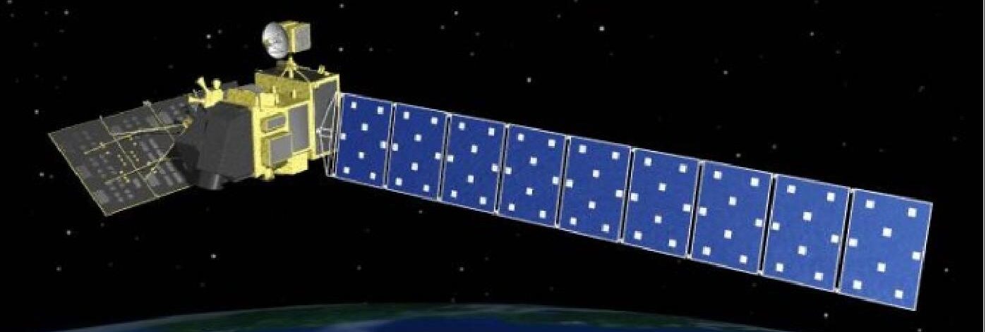
ALOS PALSAR – Overview
PALSAR has two fine beam modes: single polarization (FBS) and dual polarization (FBD), as well as quad polarization, also known as polarimetric mode (PLR). ScanSAR wide beam (WB1, WB2) operates with a considerable loss of resolution. See table below.| Dataset Property | Fine Resolution | Fine Resolution, additional | ScanSAR | Polarimetric |
|---|---|---|---|---|
| Temporal Coverage | 2006-2011 | 2006-2011 | 2006-2011 | 2006-2011 |
| Repeat Cycle | 46 days | 46 days | 46 days | 46 days |
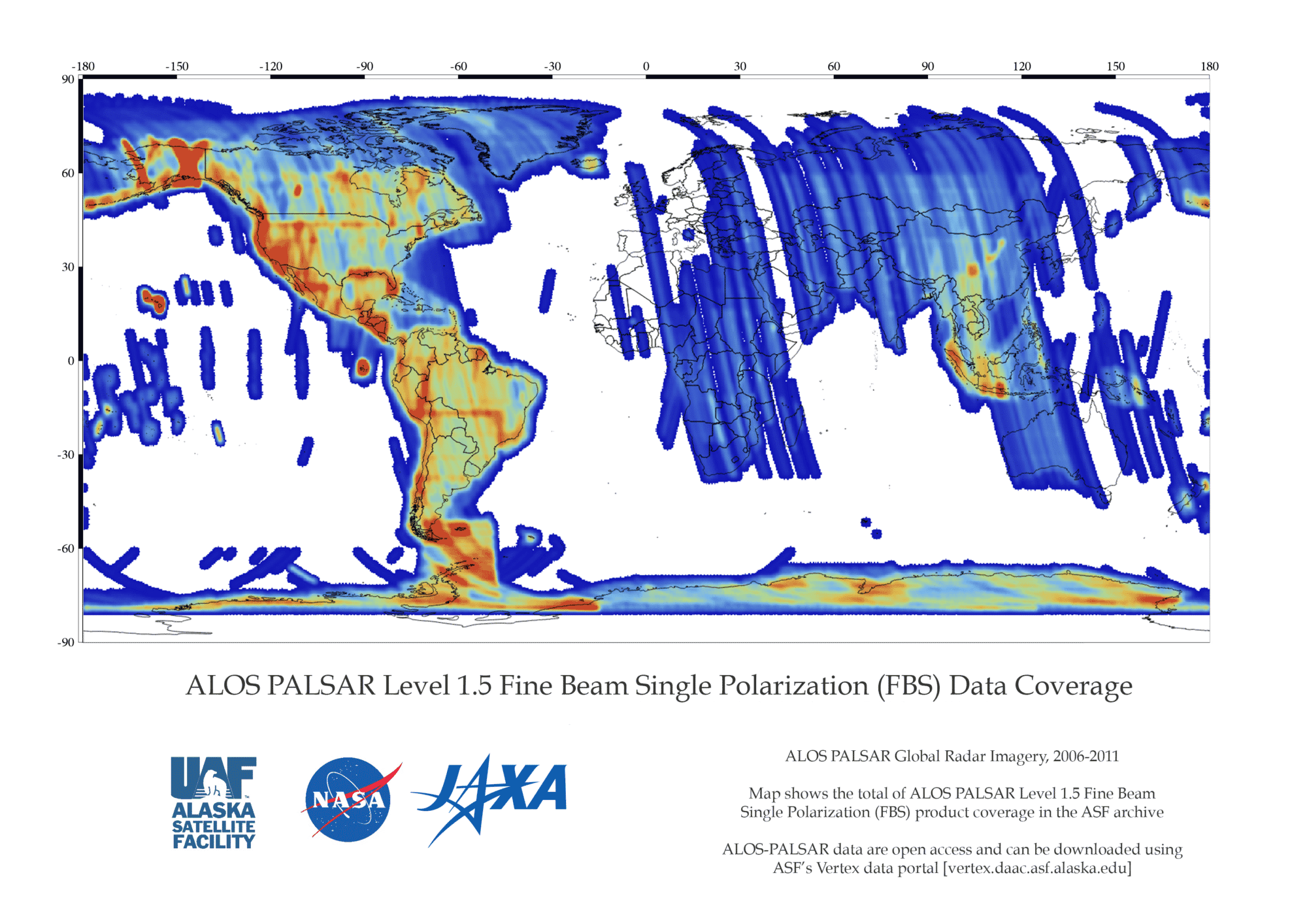
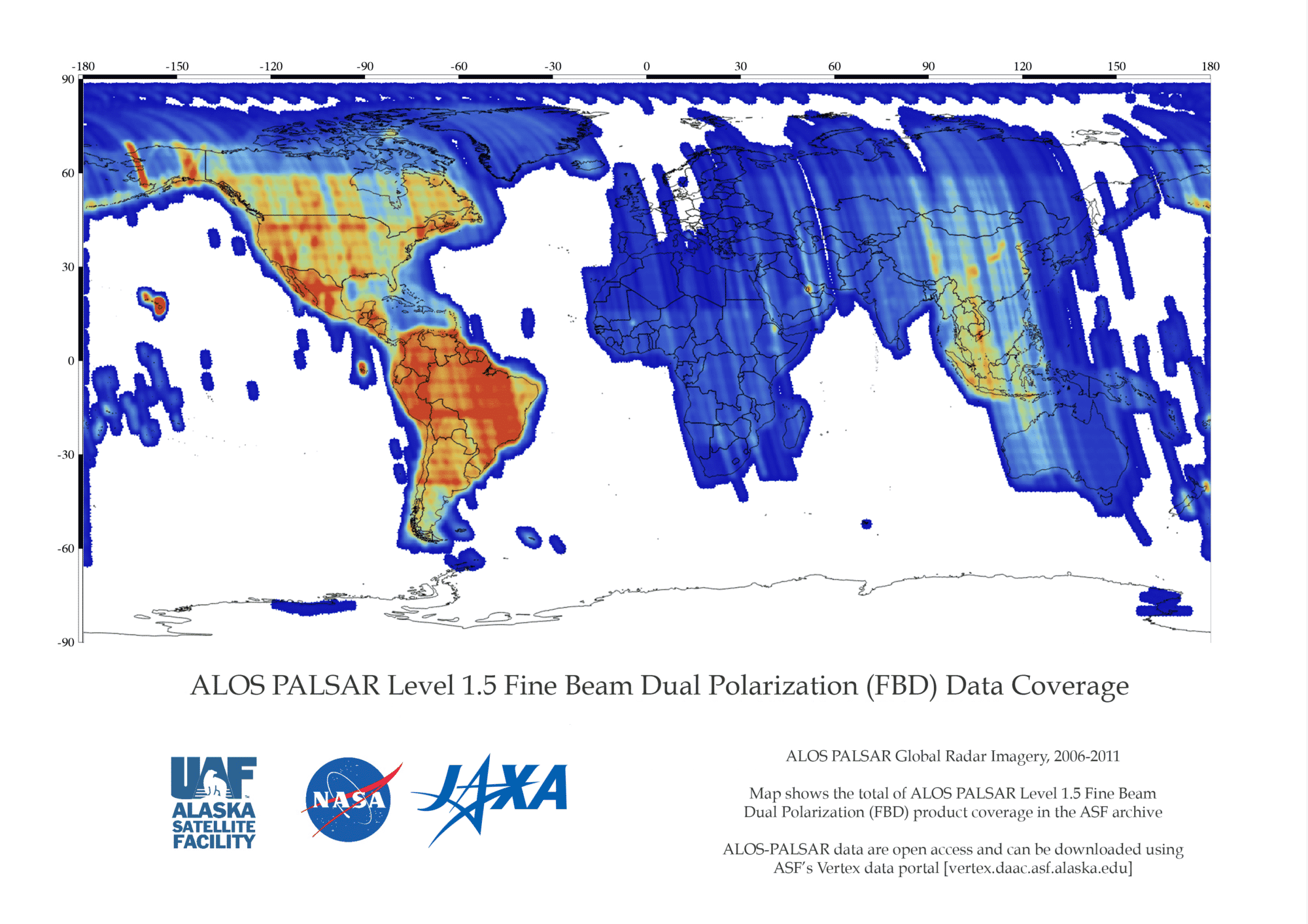
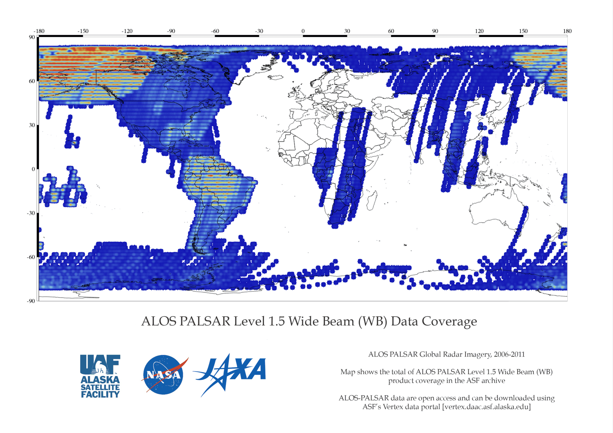
| Spatial Coverage | North, Central, and South America – Complete Outside the Americas – Partial | North, Central, and South America – Complete Outside the Americas – Partial | North, Central, and South America – Complete Outside the Americas – Partial | North, Central, and South America – Complete Outside the Americas – Partial |
| Beam Mode | FBS, DSN | FBD | WB1, WB2 | PLR |
| Center Frequency | L-Band (1.27 GHz) | L-Band (1.27 GHz) | L-Band (1.27 GHz) | L-Band (1.27 GHz) |
| Polarization | HH or VV | HH+HV or VV+VH | HH or VV | HH+HV or VV+VH |
| Spatial Resolution | 10 m | 20 m | 100 m | 30 m |
| Swath Width | 70 km | 70 km | 250-350 km | 30 km |
| Off-Nadir Angle | 34.3° (default) | 34.3° (default) | 27.1°(default) | 21.5° (default) |
| License | See License and Data Citation tab | See License and Data Citation tab | See License and Data Citation tab | See License and Data Citation tab |
| Download info | Data Discovery | Data Discovery | Data Discovery | Data Discovery |
| File format | L1.0,L1.1,L1.5,L2.2, RTC_LOW_RES, RTC_HI_RES,KMZ | L1.0,L1.1,L1.5,L2.2, RTC_LOW_RES, RTC_HI_RES,KMZ | L1.0,L1.1,L1.5,L2.2, RTC_LOW_RES, RTC_HI_RES,KMZ | L1.0,L1.1,L1.5,L2.2, RTC_LOW_RES, RTC_HI_RES,KMZ |
| Provider | Japan Aerospace Exploration Agency (JAXA). | Japan Aerospace Exploration Agency (JAXA). | Japan Aerospace Exploration Agency (JAXA). | Japan Aerospace Exploration Agency (JAXA). |
| Date published: | 2006-2011 | 2006-2011 | 2006-2011 | 2006-2011 |
| Read more: | ALOS-PALSAR on the JAXA Website |
PALSAR cannot observe the areas beyond 87.8 degrees north latitude and 75.9 degrees south latitude when the off-nadir angle is 41.5 degrees. Read more on the JAXA website.
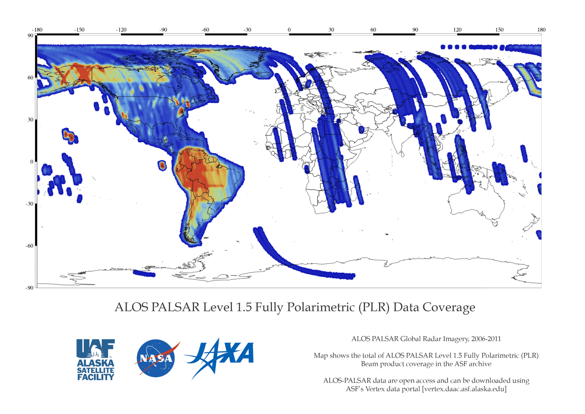
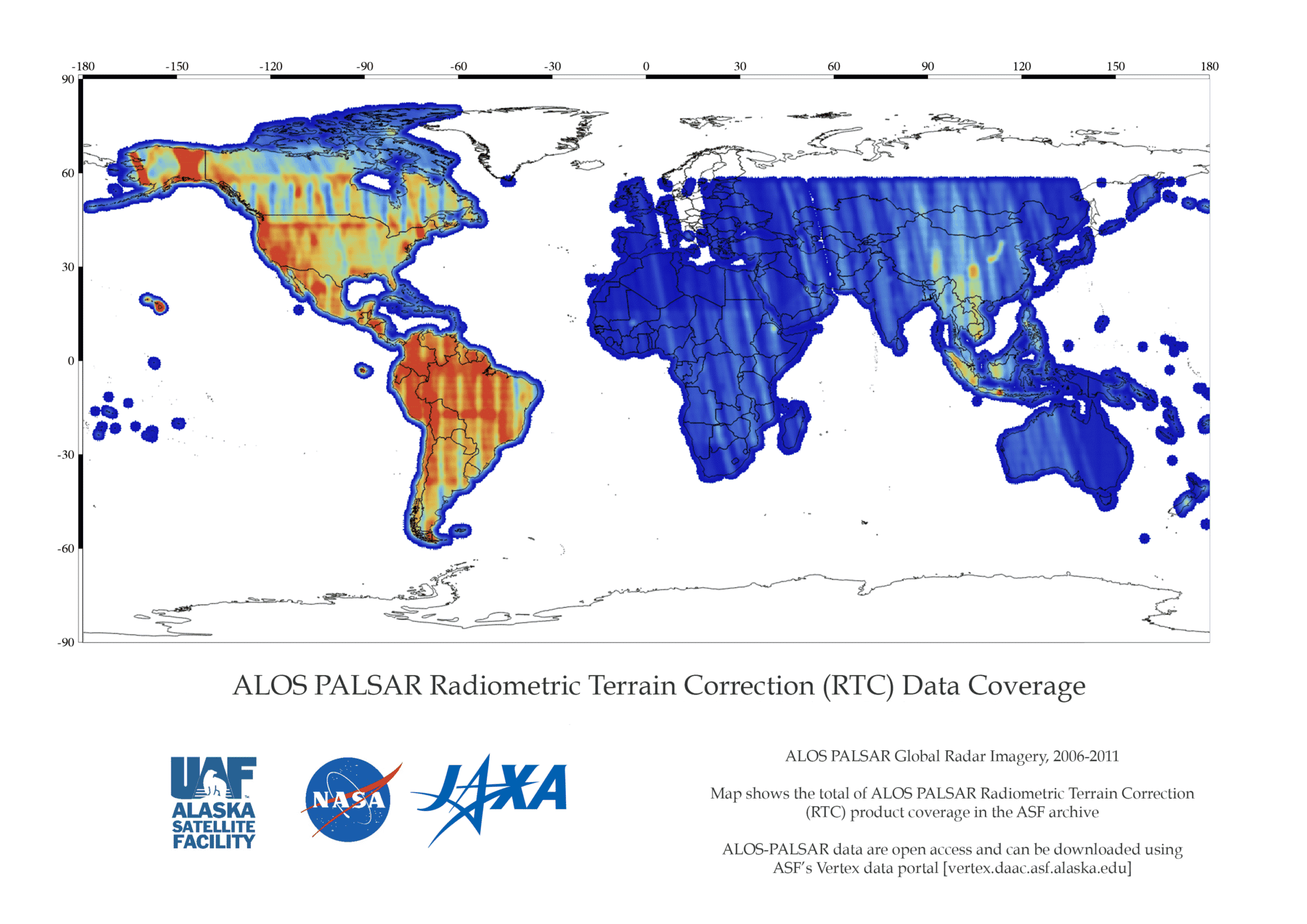
Coverage Maps
PALSAR Documentation
PALSAR – Documentation
| Name | Description |
|---|---|
| ALOS Data Users Handbook, 2008 ALOS Data Users Handbook,2008 | Overview of the ALOS Project and related technical information on satellites and land systems |
| ALOS User Guide | Overview, products, product format, operations |
| PALSAR Product Format | Detailed L1.1 and L1.5 product format description |
| Detailed L1.0 product format description |
PALSAR RTC Information
For information and documentation regarding the ALOS PALSAR radiometric terrain corrected (RTC) products available from ASF, please go to:
Software Tools
ALOS PALSAR Software Tools
| Name | Description |
|---|---|
| MapReady, ASF | Terrain correct, geocode, and apply polarimetric decompositions to multi-pol SAR data |
| Convert to Vector, ASF | Transform point or scene information to formats compatible with Google Earth, GIS, and more |
| Other Software Tools | Access a variety of tools for viewing, analyzing, and processing radar data |
GIS Platforms
ALOS PALSAR GIS Platforms
RTC GeoTIFF products are readily visualized in GIS programs such as ArcGIS or QGIS.| Name | Description |
|---|---|
| QGIS: open source | Windows, Mac, Linux, BSD |
| ArcGIS: commercial software | Windows, Linux |
Processors
ALOS-PALSAR – PALSAR Processor
PALSAR Processor versions used to process data at ASF.| Processing Dates | Processor Version | JAXA Calibration Result as of (MM-DD-YYYY)​ |
|---|---|---|
| April 18, 2007- April 26, 2007 | 3.00 | 10-23-2006 3-29-2007 |
| April 27, 2007- March 17, 2008 | 4.00 | 3-29-2007 9-28-2007 |
| March 18, 2008 – June 12, 2008 | 4.03 | 9-28-2007 |
| June 13, 2008 – February 3, 2009 | 5.00 | 9-28-2007 |
| February 4, 2008 – ? | 5.04 | 9-28-2007 7-1-2009 |
| September, 2013 | 6.07 | 9-6-2011 |
ALOS-PALSAR-Optical Processor
Optical Processor versions used to process data at ASF.| Processing Dates | Processor Version | JAXA Calibration Result as of (MM-DD-YYYY)​ |
|---|---|---|
| April 18, 2007- April 26, 2007 | 3.00 | 10-23-2006 3-29-2007 |
| April 27, 2007- March 30, 2009 | 4.01 | 3-29-2007 9-28-2007 |
| March 31, 2009 – February 3, 2010 | 5.02 | 9-28-07 7-1-2009 |
| February 4, 2010 – January 18, 2011 | 5.09 | 7-1-2009 |
| January 18, 2011 – Present | 6.03 | 7-1-2009 |