International Polar Year (IPY) was a collaborative research event focused on the Arctic and Antarctic. The history of IPY started in 1882 with the first year-long International Polar Year. Since then, a second IPY occurred in 1932-33 and an International Geophysical Year took place in 1957-8. Organized by the International Council for Science (ICSU) and the World Meteorological Organization (WMO), the fourth IPY spanned two years (2007-2009) in order to emphasize a sense of urgency in polar research. As polar research has continued, IPY has recognized that changes in polar areas have a global impact.
Changes in the extent, thickness and duration of snow and ice in polar regions affect local ecosystems and economic hot spots like fisheries and agricultural areas. Millions of lives around the globe, especially those living in the north, are affected by these changes in food and water availability and arctic pollution. IPY 07-09 focused on collaborative research and extensively explored the complex relationships between the Arctic and Antarctic and other elements. Over 60 countries and thousands of researchers participated, investigating more than 200 projects. Topics included Arctic and Antarctic relationships with geophysical elements, oceans and sea ice, Earth’s atmosphere, space, and human relations (a new IPY topic).
The focus on collaborative research was intended to build a foundation of international, interdisciplinary partnerships in the scientific community that would continue after IPY 07-09 ended. Cooperative research partnerships would aid polar research in making progress with fewer obstacles, and allow scientists and global communities alike to understand the effects of change in polar regions.
Global Inter-agency IPY Polar Snapshot Year (GIIPSY)
ASF hosts an archive of the IPY project titled the Global Inter-agency IPY Polar Snapshot Year (GIIPSY). GIIPSY’s objective was to obtain high-definition satellite snapshots of the polar regions during 2007-2008. The primary purpose is to use these snapshots as benchmarks for gauging past and future environmental changes in the polar ice, ocean, and land.

GIIPSY Missions Snapshot
In the spirit of IPY, GIIPSY scientists also seek to secure these datasets as our legacy to the next generations of polar scientists. GIIPSY comprises a group of polar scientists from around the world who have assembled a consolidated list of thematic objectives that call upon the collective resources of international and national space agencies. The programmatic goal is to identify ways in which the resources of space-faring countries can be used in such a way as to collect data with which to address these scientific objectives, without putting undo burden on any single organisation. To that end, GIIPSY seeks cooperation in terms of spaceborne instruments, data relay systems, ground segments, processing, and data archiving and distribution capabilities.
International Polar Year – GIIPSY Documents, Publications, and Mission Plans
Documents
- GIIPSY Proposal to ICSU/WMO Joint Committee on IPY
- GIIPSY Endorsement Letter
- Letter announcing ESA IPY AO
- GIIPSY vu-graph package
- Data Strategy 3.0 NEW!
GIIPSY Close Out Package (pptx, pdf, ppt)
Science Data Requirements and Mission Planning
The following files summarize a community assessment of GIIPSY satellite data requirements. Detailed requirements and justifications are discussed in the GIIPSY Science Requirements Document. A consolidated and numbered set of science themes are listed in GIIPSY Thematic Objectives. These were presented and tentatively adopted by the Space Task Group. A spread sheet linking GIIPSY thematic objectives by number to specific observational requirements is included as the GIIPSY Check List. The GIIPSY Check List also refers to image and digital maps listed below.
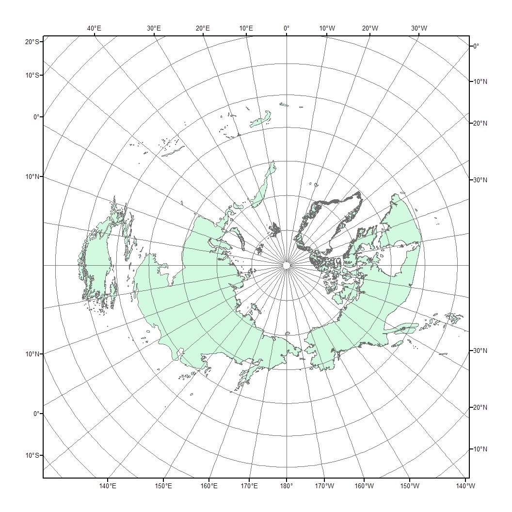
Image Maps of Coverage
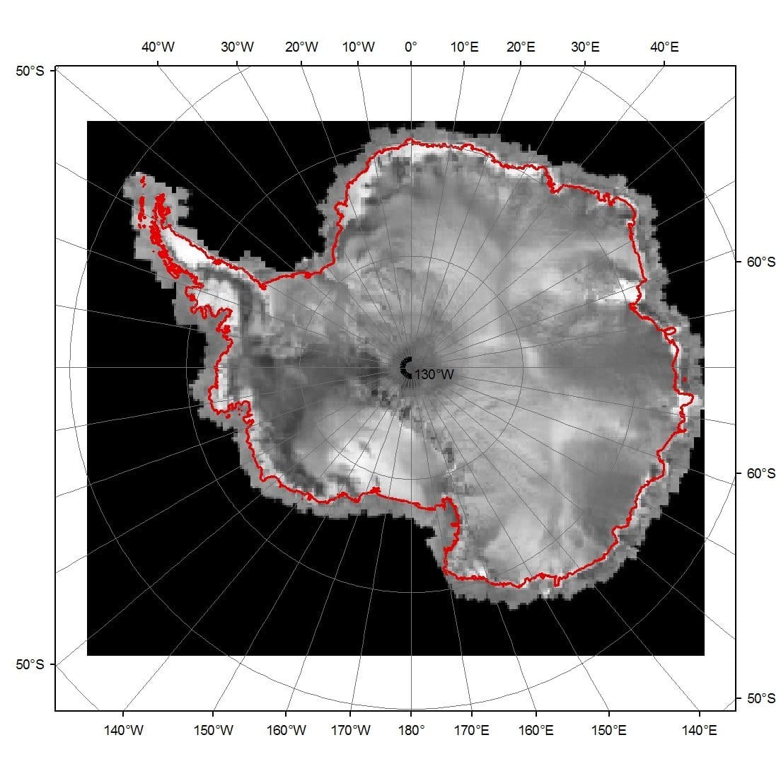
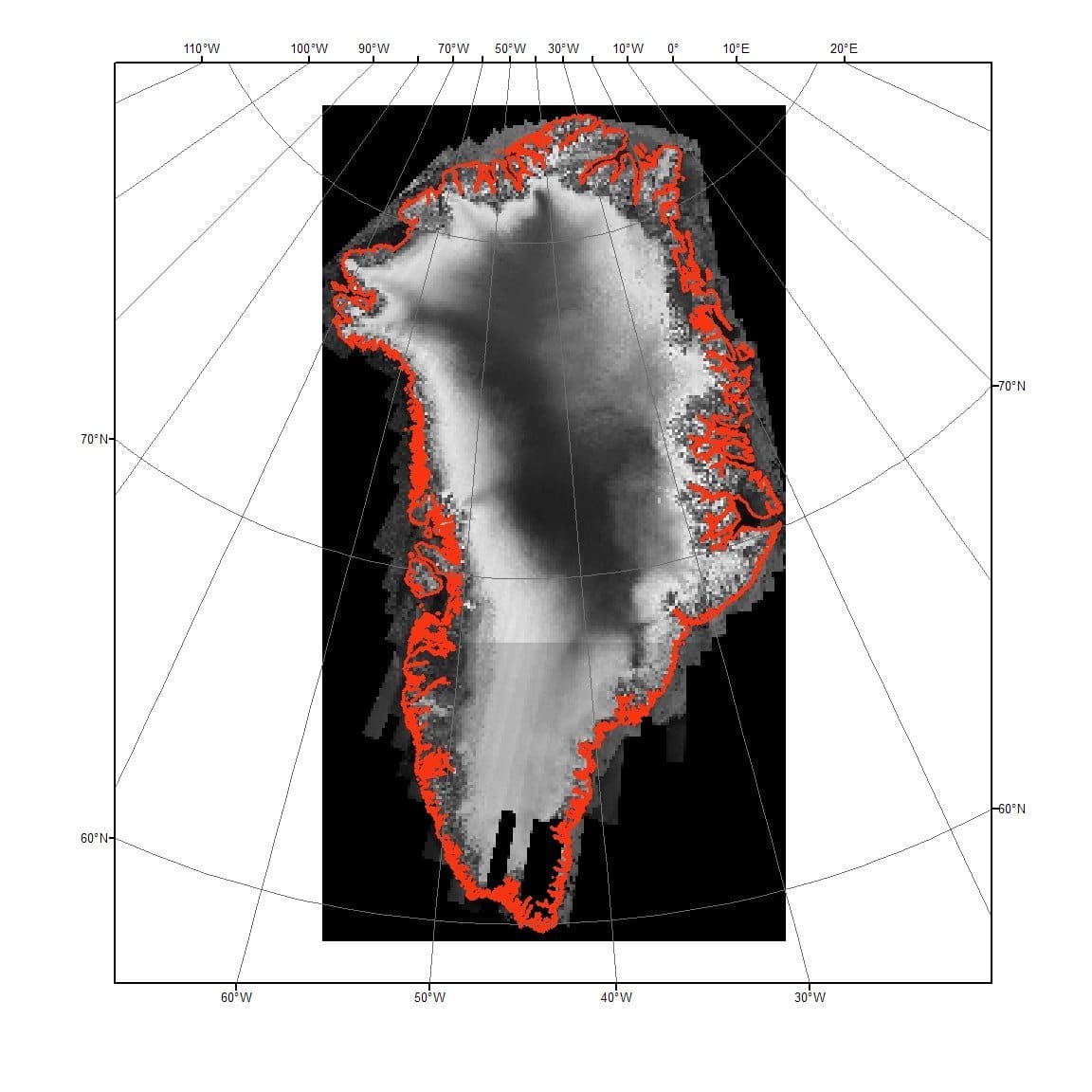
Antarctica and Greenland Ice Sheets
| IPY Imagery | Antarctica and Greenland Ice Sheets |
|---|---|
 |  |
 |  |
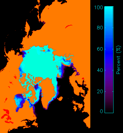
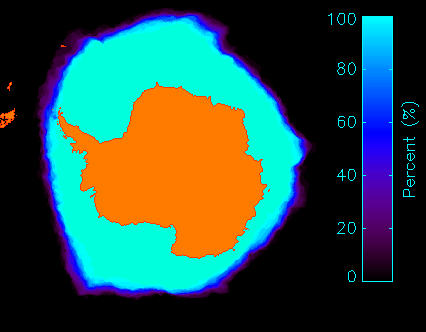
Arctic and Antarctic Sea Ice
| IPY Imagery | Arctic and Antarctic Sea Ice |
|---|---|
 |  |
 |  |
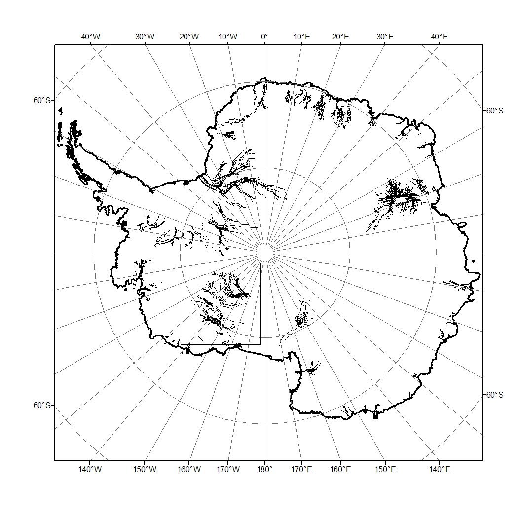
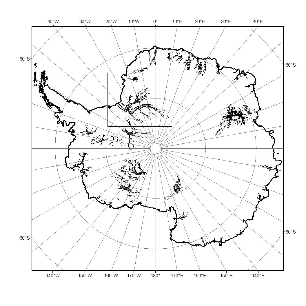
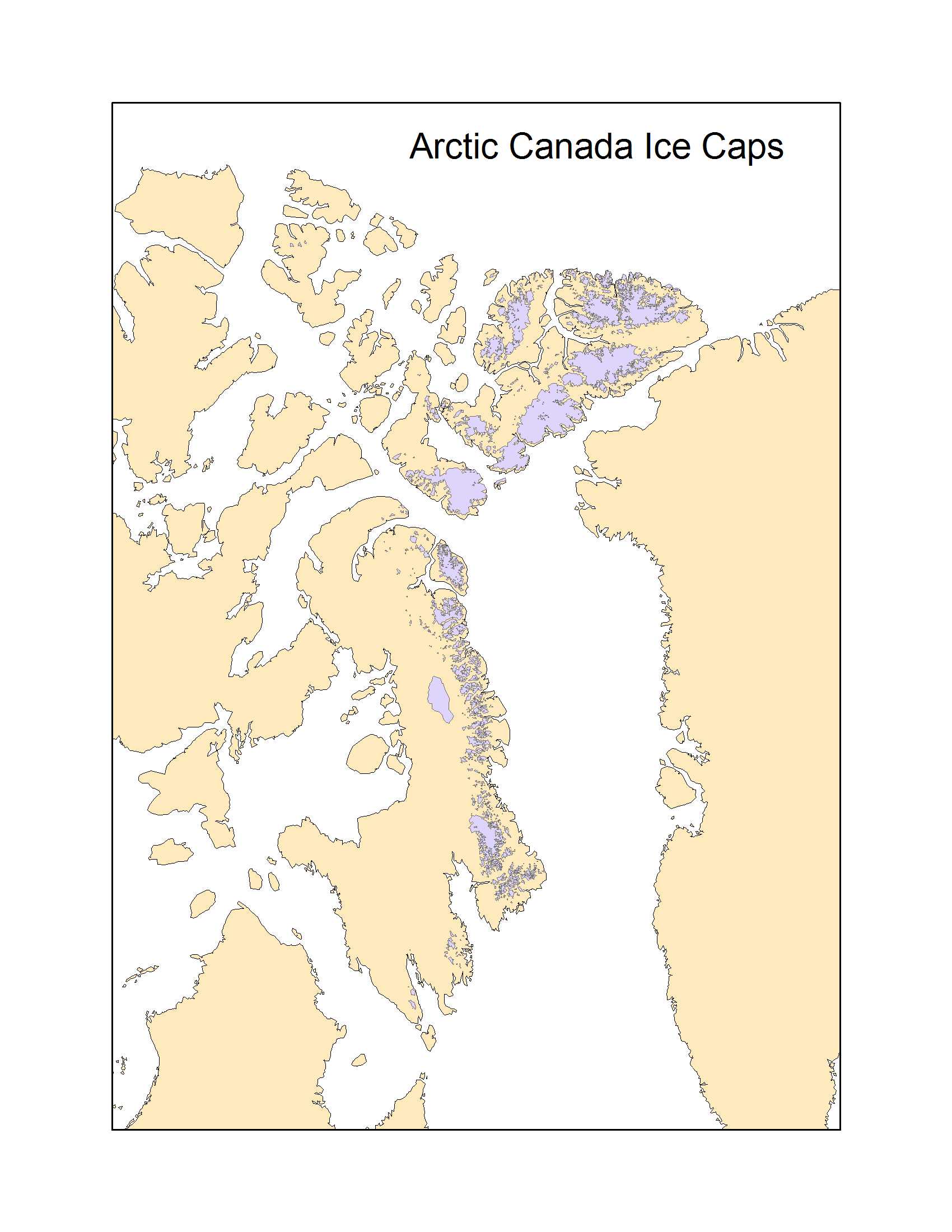
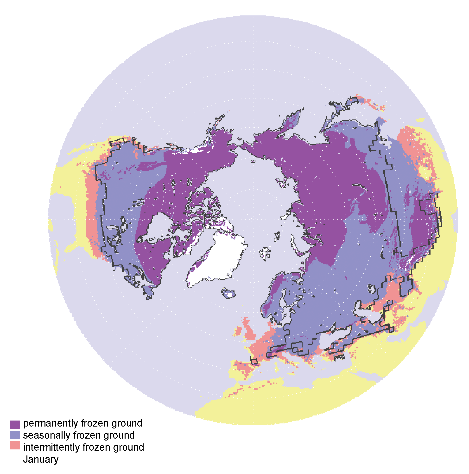
Glaciers
| IPY Imagery | Glaciers and Permafrost |
|---|---|
 |  |
 |
Lake and River Ice
Digital Maps
Antarctica
Greenland
Glaciers
Sea Ice
- Arctic Summer Sea Ice Extent (raster data)
- Arctic Winter Sea Ice Extent
- Antarctic Summer Sea Ice Extent
- Antarctic Winter Sea Ice Extent
- Sea ice data format (text file)
Permafrost
Publications
- EOS December 12, 2006
- ASF Newsletter
- EGU ‘07 Poster
- Space Research Today
- WMO State and fate of the polar cryosphere
- Earthzine Article
- Space Technology Today
- Imaging Notes
- Environmental Geology
- CNES SPIRIT
- Environmental Earth Science Gottwald
- EOS 2010
- CSA SAR COORDINATION SUMMARY
Mission Plans
IPY Proposal Selections
IPY Space Agency Data Portfolio Information and AO Links
- ESA IPY Data Portfolio — June
- CSA IPY Data Portfolio — June
- ESA IPY Data Portfolio — Nov
- NESDIS IPY Portfolio
- DLR Data Portfolio
- DLR Data Portfolio Access
- ISRO AO Information — OceanSat–2
- ASI IPY Data Portfolio (Battazza)
- TEMIS Atmospheric Products
- JAXA Products
- Dataset Sampler and Demonstration
GIIPSY Links
- IGOS Cryopshere
- ESA Data Access
- Radarsat SPA Archive
- ESA Data Portal: ESA catalogue of portals
- ASI COSMO-SkyMed
- SPIRIT (SPOT DEMS)
Other Data Links
- MERIS Images
Atmospheric Chemistry - POLARCAT
- SCIA Data Browser
- STG Members and EOS Co-Author List
International Polar Year – GIIPSY – Space Task Group Meetings 2006 – 2008
2006
- Briefing to WMO, GEO and IPY JCOMM SCOBS, Oct. 12 (Drinkwater)
- Briefing to IGOS Cryosphere Team, Oct. 16, ESTEC
- Briefing at NSIDC, Oct. 25, Boulder
- Presentation at IGS Nordic Branch, Tromso, Oct. 2006 (Lytle)
- GIIPSY participation in CSA Radarsat-1 Archive Processing Meeting, Nov. 8, Ottawa
- GIIPSY Team meeting, Dec 12
- Briefing to WCRP CLiC, Boulder, Colorado, Dec. 6 (Drinkwater)
![]()
AGU Fall Meeting GIIPSY (December 12, 2006)
Marriott Convention Center, Room Sierra K, San Francisco | 6:00PM-8:30PM
Draft Agenda
Perspectives (~45-60min)
- 10 min GIIPSY Overview and Meeting Objectives (K. Jezek)
- ~5 min discussion on how GIIPSY fits into IPY (D. Carlson)
- ~5 min IGOS and GIIPSY (V. Ryabinin)
- ~5 min ESA presentation on ESA IPY AO proposals (Einar-Arne Herland, ESA)
- ~5 min CSA perspective on GIIPSY and Radarsat-1 Archive (P. Briand)
- ~5 min Japanese perspective on GIIPSY (J. Ukita)
- ~5 min NASA perspective on GIIPSY (S. Martin)
- ~5 min Ground Station perspective on processing large volumes of data (N. La Belle-Hamer)
- ~5 min DLR perspective on GIIPSY (K. Jezek for I. Hajnsek)
Topics for discussion (K. Farness) (1-1.5 hour)
1) Community input to flight agencies on archival data processing and new data acquisitions
2) Identify key IPY legacy data set(s)
What?
Where?
When? (for example: during windows of seasonal melt or alternatively during cycles of ICESAT data acquisitions?)
3) Related issues and potential additional resources
Sensors and Spacecraft
Acquisition Planning
Receiving Ground Stations
Processing Facilities
Calibration and Validation
Distribution
4) Data management issues
Processing and product distribution
Product format
Metadata tagging for data explicitly collected for IPY including:
Insitu data
GIIPSY pull from the CSA archive
2007
- Space Task Group meeting in Geneva, January 17-19, 2007
- IPY Launch Event, Paris, March 1, 2007
- Space Task Group telecom, June 15, 2007 – (ESA Data Portfolio)
- Space Task Group Telecon, August 8, 2007 – (ASAP (RADARSAT-1) Portfolio)
- IICWG, October 2007, ESRIN, Frascatti
- Space Task Group Meeting, November 26-27, 2007, Darmstadt (Agenda, Presentation, and Background Material)
![]()
STG Meeting Geneva, WMO Headquarters (January 17-19, 2007)
Geneva, WMO Headquarters
Day 1
- Opening (welcome by Prof H.Yang, WMO Deputy Secretary-General)
- IPY Introduction (M. Drinkwater)
- Status of the IPY preparation (E. Sarukhanian for D. Carlson)
- Report on activities of Sub-Committee on Observations (SCOBS). Including background to Space Task Group (T. Mohr/W. Zhang)
- WCRP IGOS-Cryosphere Theme (V. Ryabinin)
- GIIPSY/Baseline Scientific Requirements for IPY datasets (K. Jezek)
- Agency presentations on existing IPY plans/proposals
- ESA (H. Laur)
- NASA (C. Dobson)
- ROSHYDROMET (V. Asmus): Pres 1; Pres 2
- DLR (M. Gottwald)
- EUMETSAT (K. Holmlund)
- CSA (J-M. Chouinard): Polar View
- CMA (L. Zhao)
- CNES (E. Thouvenot)
- Operational vs. Scientific missions (All)
Day 2
- Leaving an IPY legacy
- “The Polar Snapshot” K. Jezek, Example Acquisitions
- Geo Contribution (M. Rast and E. Sarukhanian)
- Mechanisms for collecting IPY data requirements
- SCOBS survey of IPY sat. data needs (E. Sarukhanian)
- Other Agency IPY AOs (All)
- Establishing the priorities for near-term/medium-term/long-term actions
- Acquisition planning/Tasking satellites (All)
- Data Management/Metadata standards (All)
- Archiving and Data Distribution (All)
- Data Policy (All)
- Discussion on Agency Commitments
- Baseline plans for data acquisitions
- Archiving and distribution
Day 3 (half-day)
- Missing Agencies
- Consolidation of Action Items
- Time and place of next Meeting
- Meeting Closure
Summary Documents
Space Task group of the IPY Sub-Committee on Observations (November 26-27, 2007)
Eumetsat, Darmstadt, Germany
Agenda, Presentation Summary, Attendees
Presentations (presenter initials — topic)
1. MD — Agenda
2. MD — GIIPSY
3. JL — HRPT Coverage
4. MG — DLR
5. AR — DLR-TSX
6. ET — CNES
7. ES — JC
8. YC — CSA
9. RK — GIIPSY
10. HL — ESA
11. FL — NASA
12. PCC — NOAA
13. OG — IPY-DM
Related Materials
Supporting Documents
- Doc 1 IPY STG 2 Agenda
- Doc 2 IPY STG1 Summary
- Doc 3 IPY STG Telecon 1 Minutes
- Doc 4 IPY STG Telecon 2 Minutes
- Doc 5 IPY SCOBS Report
- Doc 6 IPY IGEOLAB Report
- IPY STG-2 Outcome of CGMS
Summary Documents
2008
- STG SAR Workshop, March 2008, St. Hubert (Agenda, Presentations, and Background Material)
- Space Task Group Meeting, May 5-6, 2008, ESRIN Frascati, Italy (Details and Summary Reports)
- STG IPY Session, SCAR, July 2008, St. Petersburg, Russia
- STG SAR Workshop 2, Sept. 30-Oct. 1, 2008, DLR Oberpfaffenhovfen, Germany (Details)
![]()
Space Task Group of the IPY Sub-Committee on Observations SAR Workshop (March 5-6, 2008)
Canadian Space Agency, St. Hubert, Canada
As part of ongoing IPY Space Task Group activities, the Canadian Space Agency hosted an IPY SAR/InSAR workshop in response to an action item from STG-1. The goal of the meeting was to develop an acquisition strategy for SAR and InSAR data that achieves the maximum number of IPY science objectives in such a way as to distribute the acquisition load across the different agencies – understanding that no single agency can accommodate all of the tasks. This will require a level of coordination between the space agencies that has not yet been attempted. The workshop focused on data acquisition requirements, as outlined by the scientific community, based on Agency strategic plans for IPY and unique capabilities of their systems. Data processing and distribution issues were briefly addressed but the primary objective was to populate the archive given the unique opportunity of IPY.
The workshop main tasks were:
1) To review existing GIIPSY science requirements as outlined in the Global Inter-agency IPY Polar Snapshot Year (GIISPY) Strategy Document.
2) To present the Agencies strategic priorities in line with IPY science activities.
3) To present and review SAR data which are being collected, and are planned for collection during the IPY.
4) To present the satellite and ground segment operators system capabilities and constraints related to the acquisition of data in support to IPY.
5) To attempt to forge a coordinated / multi-agency SAR acquisition plan for the remainder of IPY acquisitions.
In order to meet these ambitious objectives, invited attendees, which include members of the science and operational communities, space agencies operating SAR satellite; space agencies with data transmission, ground segment and processing capabilities, and ground segment operators, were requested to actively contribute to the achievement of the workshop objectives.
Logistical Information
Agenda and Presentations
- Agenda
- Meeting Introduction (YC)
- STG Background (YC)
- GIIPSY Background (KJ)
- ESA Portfolio (HL)
- ESA and IPY (YD)
- ESA Constraints (HL)
- DLR Strategic Objectives (ED)
- DLR IPY Data Constraints (ED)
- TerraSAR Capabilities (DF)
- TerraSAR Data Access (DF)
- CSA Strategic Objectives (YC)
- R1 Constraints (RSJ)
- R2 Allocation (DdL)
- ASF and JAXA (DA)
- Ice Services (DL)
- CNES Complementary Optical Studies (ET)
- Summary and Action Items (YC and KJ)
- Meeting Minutes
- Participants List
Data Acquisition Plans
- Strawman Acquisition Strategy Spreadsheet
- Antarctic Acquisition Template
- Sea Ice Acquisition Template
- Arctic Land Ice Acquisition template
Space Task Group of the IPY Sub-Committee on Observations (May 5-6, 2008)
ESRIN, Frascati, Italy
Logistical Information
Agenda
Background Documents
- SAR Coordination Summary: CSA Workshop
- STG 2 Meeting Notes
- STG 3 Doc 2 (IPY Status)
- STG 3 Doc 4 (Global Cryosphere Watch)
- List of Documents
- Preliminary List of Participants
Presentations
1. IPY Status
2. SAON Results
3. SAR Workshop Summary
4. GIIPSY Update
5. ASI COSMO-SkyMed IPY Status
6. JAXA IPY Status
7. CNES IPY Status
8. CSA IPY Status
9. DLR IPY Status
10. ESA IPY Status
11. EUMETSAT IPY Status
12. NOAA IPY Status
13. IGeoLab WMO Report
14. Data Management
15. WIGOS
16. Global Cryosphere Watch
17. VisIR Progress
Summary Material
Space Task Group of the IPY Sub-Committee on Observations SAR Workshop (September 30 – October 1, 2008)
DLR, Oberpfaffenhofen, Germany
As a follow up to the STG action to enhance the coordination among the SAR Space Agencies in response to the IPY scientific objectives, a SAR/InSAR coordination workshop was held on 5/6 March 2008 at the Canadian Space Agency. As a result of this meeting, the SAR operating Agencies agreed on the strategic guidelines for imaging activities and for thematic priorities as outlined by the science community. Despite the significant way forward and considerable efforts we are putting to fulfill our commitments, there is still a need to develop a SAR Acquisition Consolidated Plan and discuss the way forward for a SAR processing strategy and data dissemination plan.
As part of the SAR coordination process, the German Aerospace Center (DLR) is organising a second meeting to address the harmonisation and coordination of the acquisition plans. The objectives of this meeting are:
* Consolidate the current SAR planning and imaging activities occurring under the auspices of IPY/STG in order to avoid gaps and overlaps and optimize resources (i.e. thematic / instrument matrix, common planning tool, etc.)
* Distribute imaging load according to Agencies’ capacities and priorities, and develop acquisition plans
* Look at a short/med/long term planning approach to continue the acquisitions (if at all possible)
The meeting will be held at the DLR facilities in Oberpfaffenhofen (Germany).
We now established the date of the workshop on 30 Sept./1 Oct.2008.
Logistical Information
GIIPSY Draft Acquisition Plan Recommendation for TSX.
These plans were prepared to provide DLR with an estimate of SAR loading for Antarctic regions south of about –80°. Comments welcome. These are in addition to any individual proposals and to several super-site areas that the STG is considering in Greenland and Antarctica.
Filchner Ascending
Filchner Descending
TAM Ascending
TAM Descending
JAXA IPY Web Site (Comments welcomed by Dr. Masanobu Shimada)
Japanese: JAXA website | JAXA IPY Dataset page
English: JAXA website | JAXA IPY Dataset page
PALSAR Animations. Antarctic: /A, /B, /C
ESA/ESRIN Acquisitions and Plans
- Information on upcoming ERS-2 acquisition from O’Higgins Station
- Acquisition map for O’Higgins Station
- Animation of ESA SAR data over Lincoln Sea. Courtesy Ron Kwok
- Participants List
Agenda
Presentations
1) Buckreuss and Roth, DLR
2) Crevier, CSA
3) Jezek, OSU
4) Del Rio Vera, Drinkwater and Laur, ESA
5) Saint-Jean, CSA
6) Rigby, MDA
7) Hajnsek, DLR
8) Floricioiu, DLR
9) Braun, U Bonn
10) Helm and Miller, AWI
11) Hall, KSAT
Minutes
Meeting Minutes
International Polar Year – GIIPSY – Space Task Group Meetings 2009 – 2011
2009
- STG Meeting, February 2009, Geneva (Agenda, Presentations, and Background Material)
- 3rd SAR Workshop, June 2009, Frascatti (Agenda, Presentations, and Background Material)
- STG Meeting, December 2009, Geneva (Agenda, Presentations, and Background Material)
![]()
IPY Space Task Group Meeting (February 3-4, 2009)
Geneva
Presentations
- Drinkwater
- Sarukhanian
- Crevier
- Gottwald (DLR portfolio)
- Gottwald (polar atmosphere)
- GOME animation
- SO2 image
- Godoy
- Thouvenot
- Key (NOAA Portfolio)
- a. Key (Polar Atmosphere)
b. Key (HRPT) - Goodison
- Ryan
- Del Rio Vera
- Arctic Flash Image
- Antarctic Flash Image
- a. Crevier (CSA update)
b. Crevier (Greenland)
c. Crevier (Antarctica)
d. Crevier (Polar Coms) - Key (CEOS gap analysis)
- GIIPSY Activities and Status (KJ presented by KF)
- Etna Deformation Video
- IRSPECTRA
- USGS 1
- USGS 2
- USGS 3
- USGS 4
Background Material
Minutes of Meeting
Space Task Group of the IPY Sub-Committee on Observations SAR Workshop (June 23-24, 2009)
ESRIN, Frascatti, Italy
Participants List
Agenda
Presentations
- CSA Data Portfolio Update (Crevier)
- ASAR Acquisition Strategy Update (Del Rio Vera)
- DLR TXS Update (Floricioiu)
- NASA MEaSUREs (Dobson)
- ASI IPY Data Portfolio (Battazza)
- DUE Projects in the Cryosphere (Seifert)
- ESA Climate Change Initiative (Arino)
- PolarView — BAS (Flemming)
- PolarView — DTU (Pederson)
- Data Processing Strategy (Jezek)
- RAMP Metadata (Farness)
- IPY STG Communications (Drinkwater)
Minutes
IPY Space Task Group Meeting (November 30 – December 2, 2009)
Geneva
Agenda
Presentations
- IPY Status
- SAR Coodination
- ASI Data Portfolio
- Atmospheric Data
- DLR Portfolio
- CSA Report
- ESA and IPY
- Polar Communications, Space and Arctic
- IPY Data Managmeent
- Space and the Arctic
- Global Cryospheric watch
- WCRP
- International Polar Decade
- IPY SCOBS Status
Meeting Summary
Functions and Requirements Document
2010
Oslo IPY Meeting and STG Meeting (June) (Agenda, Presentations, and Background Material)
![]()
IPY Space Task Group Meeting (June 10, 2010)
Oslo, Longyearbyen Room (S20), 09:00hrs – 17:00hrs
Agenda (Very Preliminary)
Background Material
- Drinkwater et al Presentation (PPT)
- Drinkwater et al Presentation (PDF)
- STG Accomplishments (PPT)
- CSA SAR Working Group Summary
- Conference Location and Space Posters Info
Other
- Polar Gateways Meeting, Barrow, Alaska, January 2008
- SCAR/IASC IPY Open Science Conference, July 2008 St. Petersburg, Russia
- IPY STG SAR Workshop, March 5, 6 Canadian Space Agency, Montreal, Canada
- 2nd SAR Workshop Sept 30-Oct. 1 DLR Wessling Germany
- 2008 AGU Fall Meeting (Presentations and informal get together)
- 2008 AGU FALL MEETING TASK FORCE FOR REMOTE SENSING OF PERMAFROST. G. Grosse and C. Duguay. Monday, 15 December 2008, 5:00-6:30 pm in the San Francisco Marriott Pacific Room A (Agenda)
- STG-4, Feb. 3-4, 2009, WMO, Geneva
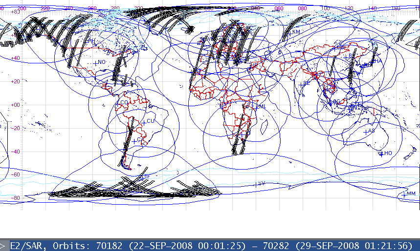
The International Council for Science (ICSU) and the World Meteorological Organization (WMO) approved the Global Interagency IPY Polar Snapshot Year (GIIPSY) as an 2007-2008 IPY project (Project #91). High-definition satellite snapshots of the Arctic and Antarctic would be invaluable polar documentation for comparing with past and future datasets. Therefore, GIIPSY worked to establish an international network of organizations willing to collaborate with their spaceborne satellites and share data processing, archiving, and distributing responsibilities. The IPY Space Task Group (STG) served as an intermediary between GIIPSY and international space agencies. GIIPSY was able to reach its goals by working with eight national space agencies and their spaceborne satellites.
Contact Information
Kenneth Jezek
1090 Carmack Road
Columbus, OHIO 43210
USA
Phone: 614-292-7973
Email: [email protected]
Mark Drinkwater
Head, Mission Science Division
ESA, ESTEC
Earth Observations
Postbus 299, 2200 AG Noordwijk
The Netherlands
E-mail: [email protected]
Tel: +31 (0)71-565-5673
Fax: +31 (0)71-565-5675